Report on Kilauea (United States) — December 1992

Bulletin of the Global Volcanism Network, vol. 17, no. 12 (December 1992)
Managing Editor: Lindsay McClelland.
Kilauea (United States) Lava continues to flow into sea as East rift zone eruption enters 11th year
Please cite this report as:
Global Volcanism Program, 1992. Report on Kilauea (United States) (McClelland, L., ed.). Bulletin of the Global Volcanism Network, 17:12. Smithsonian Institution. https://doi.org/10.5479/si.GVP.BGVN199212-332010
Kilauea
United States
19.421°N, 155.287°W; summit elev. 1222 m
All times are local (unless otherwise noted)
The . . . eruption continued in December, with flows entering the ocean at Kamoamoa, in Hawaii Volcanoes National Park (figure 86). By early December, lava had built a 1.1 km-wide delta extending 300 m into Kamoamoa Bay from the former shoreline (figure 87). Almost all of the lava erupted from the vent in early December reached the ocean through the lava-tube system, with some minor breakouts near the coast. Collapsing of the delta front (blocks up to car-size on 26 December) and slumping of the western bench at the delta's outer edge caused vigorous littoral explosions that have thrown tephra to 60 m height and built spatter cones. Breakouts of lava on the delta on 25 December were preceded by a rise in the lava level in a skylight ~1 km upslope (at the base of Paliuli: figure 87), and fieldwork revealed evidence of other recent overflows.
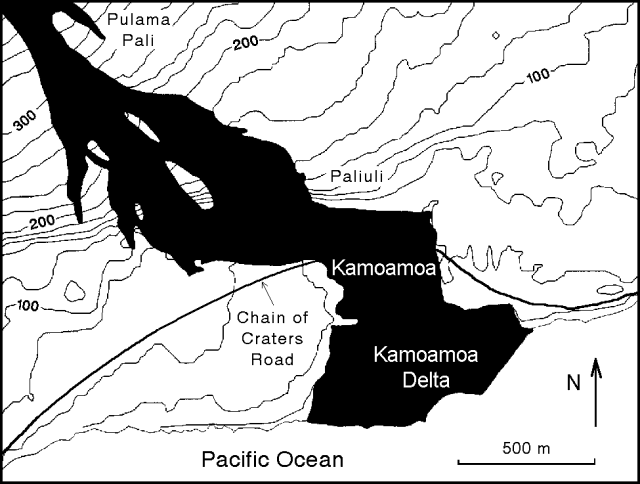 |
Figure 87. Recent episode-51 lava flows into Kamoamoa Bay from the East rift zone of Kīlauea, December 1992. Courtesy of HVO. |
The eruption paused for 24 hours beginning at 1600 on 3 January, after a collapse around the E-51 vent. This was the first pause since just before E-52 began on 2 October, and marked the 10th anniversary of the eruption's start. Vent activity declined, the skylights were empty, and the ocean entries were almost inactive. Tremor amplitude decreased to background levels and there was an increase in shallow, long-period microearthquakes during the eruptive pause. Eruptive activity gradually increased starting at 1500 the next day. At 1528 lava was overflowing from a skylight in the reoccupied lava tube at ~360 m elevation, and the tube was eventually reoccupied down to the delta. The lava tube fed numerous breakouts from the top of the Pulama pali (figure 87) 3.5 km down to the delta on 5 January. There was no evidence of large surface flows or recent overflows from the skylights above the pali.
The first 10 years of the eruption have produced roughly 1.4 km3 of lava. The flow field covers > 83 km2, and ~150 hectares of new land have been added at the coast. Lava flows have destroyed 181 homes in several S-flank communities.
Geological Summary. Kilauea overlaps the E flank of the massive Mauna Loa shield volcano in the island of Hawaii. Eruptions are prominent in Polynesian legends; written documentation since 1820 records frequent summit and flank lava flow eruptions interspersed with periods of long-term lava lake activity at Halemaumau crater in the summit caldera until 1924. The 3 x 5 km caldera was formed in several stages about 1,500 years ago and during the 18th century; eruptions have also originated from the lengthy East and Southwest rift zones, which extend to the ocean in both directions. About 90% of the surface of the basaltic shield volcano is formed of lava flows less than about 1,100 years old; 70% of the surface is younger than 600 years. The long-term eruption from the East rift zone between 1983 and 2018 produced lava flows covering more than 100 km2, destroyed hundreds of houses, and added new coastline.
Information Contacts: T. Mattox and P. Okubo, HVO.