Report on Rabaul (Papua New Guinea) — August 1994

Bulletin of the Global Volcanism Network, vol. 19, no. 8 (August 1994)
Managing Editor: Richard Wunderman.
Rabaul (Papua New Guinea) Major eruption sends plume to 18 km and covers Rabaul town with ash
Please cite this report as:
Global Volcanism Program, 1994. Report on Rabaul (Papua New Guinea) (Wunderman, R., ed.). Bulletin of the Global Volcanism Network, 19:8. Smithsonian Institution. https://doi.org/10.5479/si.GVP.BGVN199408-252140
Rabaul
Papua New Guinea
4.2459°S, 152.1937°E; summit elev. 688 m
All times are local (unless otherwise noted)
Vulcan and Tavurvur, two vents on opposite sides of Rabaul Caldera (figures 15 and 12), erupted on the morning of 19 September and sent ash as high as 18 km asl. This caldera forms a sheltered harbor whose N end is occupied by Rabaul, New Britain's largest city. The report of August seismicity was sent from RVO on 9 September. Satellite interpretations are courtesy of NOAA, with TOMS data from the NASA Goddard Space Flight Center. Although communication with Rabaul was cut off for many days, RVO reports were received for 23 and 27 September. Information based on reports from local and international news services is noted, and may not be accurate.
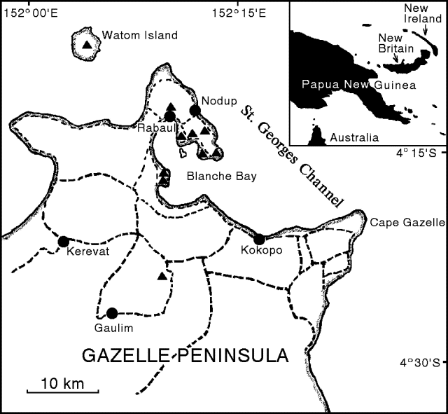 |
Figure 15. NW tip of the Gazelle Peninsula, New Britain Island, papua New Guinea, showing the road network (dashed lines), towns (dots), and volcanic centers (triangles). Modified from McKee and others, 1985. |
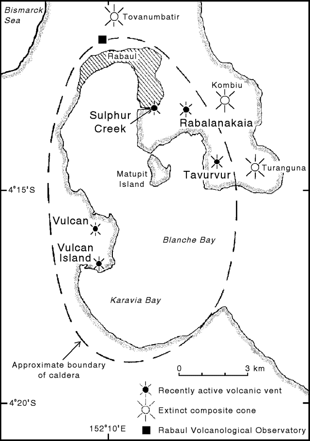 |
Figure 12. Map of the Rabaul Caldera showing recently active volcanic vents and extinct composite cones (modified from Almond and McKee, 1982). [copy from 18:03] |
August seismicity. The total number of detected events for August was 448 . . . . The month was quiet until 25-28 August when 227 earthquakes were detected, with more than half of them on the 26th. Unusually for Rabaul, these earthquakes tended to be discrete events not occurring in swarms. Only 34 of the August events were located, 25 of them during 25-28 August. Most located earthquakes were along the ring fault near Tavurvur, or offshore to the S and SW; 17 hypocenters had location errors ofL 2.6, but none of the earthquakes were felt. On 28 August, the caldera network recorded what appeared to be a low-frequency earthquake. Signals with a dominant frequency of ~1 Hz recorded on some of the inner network stations were very complicated with no clear phase arrivals or onsets. These signals probably originated close to the Matupit Island seismometer. No seismicity was recorded after 29 August.
Seismic precursors, 18-19 September. RVO reported that at 0300 on 18 September, a M 5.1 earthquake occurred beneath the harbor. An aftershock sequence from this event merged into an intensifying swarm of high-frequency (A-type) earthquakes. Peak intensity of this swarm occurred around 2400 that night with ~2 felt events/minute, but then tapered off slightly toward morning. By 0600 on 19 September the eruption had begun. Thus, only 27 hours of unusual seismicity preceded the eruption. Inspection of the seismograms since the onset of the eruption revealed several long-period events in the 12 hours prior to the M 5.1 earthquake.
Initial eruptive activity, 19 September. Tavurvur began erupting around 0600 on 19 September, followed by an explosion from Vulcan ~1-1.5 hours later. RVO volcanologist Patrice de Saint-Ours was quoted in press reports that day as stating that the pattern of eruptions was very similar to 1937, and that the vents were no longer visible from the observatory because of the ash cloud, estimated by ground observers to be >3 km high. Most press reports described thick mushroom-shaped pulses of ash rising from the vents, hot ash falling near the vents, and loud explosion noises. Aerial video footage showed vigorous, thick, light-brown ash columns, and the surface of the harbor covered with ash and floating pumice. Other press reports on 19 September stated that Rabaul town was covered with 20-25 cm of ash, and that thunderstorms mixed rain with the ash, forming a heavy mud that damaged buildings and vegetation. The press reports also described columns of gray ash rising thousands of meters into the air, ejecta as large as trucks, and "black muddy rain." Ash fell across New Britain and New Ireland.
A pilot report received at Port Moresby at 1034 placed the top of the volcanic ash cloud between 15 and 18 km altitude. A later pilot report noted the presence of drifting ash ~185 km SW of Rabaul well above 6 km altitude. GMS satellite imagery as late as 2132 on 19 September revealed an obvious plume fanning out to the S through WNW. The W part of the plume was tracking W and WNW at ~110 km/hour, and had moved across central Papua New Guinea; plume height was estimated to be 21-30 km, well into the stratosphere. The S part of the plume, at an altitude of 12-18 km, had begun to move SE at ~55 km/hour around an upper tropospheric ridge. A satellite infrared image taken a few hours earlier, at 1800 on the 19th (figure 16), showed similar plume morphology. Initial estimates of plume height during the first two days of activity were between 18 and 30 km. Space Shuttle astronauts who observed and photographed the plume (figure 17) estimated its height as at least 18 km based on altitudes of storm clouds in the area.
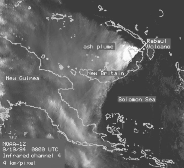 |
Figure 16. Infrared satellite image of the ash plume from Rabaul, 1800 on 19 September 1994, about 12 hours after the start of the eruption. Courtesy of George Stephens, NOAA/NESDIS. |
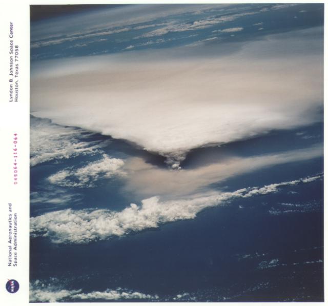 |
Figure 17. Photograph of plumes from Rabaul taken by Space Shuttle astronauts roughly 24 hours after the start of the 19 September 1994 eruption. Oblique view is to the SW. The cloud-covered island in the foreground is New Ireland, and the papua New Guinea mainland is in the distance. The eruption column rose to 18 km where it flattened out and was blown W in a fan-shaped plume. A layer of yellow-brown ash was blown towards the N by lower level winds. NASA photograph STS064-116-064, courtesy of Cindy Evans. |
Eruptive activity, 20-23 September. Video of the eruption, taken from a helicopter about 1.5 days after its start, showed massive, gray-to-black ash columns billowing vigorously from Vulcan and Tavurvur. The maximum height of the cloud was reported by the press to be ~20 km, with blocks as big as cars falling into the harbor. Black ash appeared to be falling over a wide area and scenes from Rabaul town showed buildings and vegetation blanketed by ash.
Night winds on 19 September, which were generally blowing NNE-NE (taking the ash over New Ireland), changed direction at dawn on the 20th and started blowing N-NNW, and as the afternoon progressed the winds became more westerly. By 1532 on 20 September the plume had narrowed compared to previous GMS satellite images and the core was moving WSW at ~55 km/hour at an altitude of ~12 km. As night fell on 20 September the cloud had reached the main island of Papua New Guinea between Lae and Milne Bay; residents in the town of Lae, 600 km away, reported ashfall.
On 21 September, witnesses said huge mushroom clouds of dense, black smoke and debris continued to rise high above Tavurvur and Vulcan. Much of the falling ash combined with rain, turning to a heavy mud mixture that demolished some houses and destroyed coconut plantations. The airport was buried under debris, many roads were blocked, and the harbor was covered with debris and floating pumice.
The plume was still moving WSW at 1832 on 21 September at ~7.5 km altitude, and was visible for up to 90 km SW of the origin. Soon after this time the plume was no longer clearly visible on GMS imagery, indicating that strong explosive activity, which had ejected ash high into the atmosphere almost continuously since about 0600 on 19 September, had declined. Some residents returned to Rabaul town during a brief respite from the falling ash. However, by the morning of 22 September Vulcan was ejecting massive amounts of whitish ash and Tavurvur was emitting dark blackish-gray ash. GMS satellite imagery for 1230 on 22 September revealed a new mid-high level plume that was ~40 km long and moving WSW. The plume was estimated to be at ~7.5 km altitude, and could still be seen at 1530 on GMS infrared images.
A report from RVO for the period from 1500 on 22 September through 0900 the next day indicated that volcanic and seismic activity remained relatively stable. Steady emissions continued from Tavurvur with a dark gray ash-and-vapor cloud rising ~2 km and blowing NE over Rabaul town. Low rumbling sounds accompanied the stronger emissions. At night, incandescent ejecta could be seen falling on the NW flank, but incandescence was rarely visible in the eruptive column due to its high ash content. Intermittent pulses of stronger activity from Vulcan produced jets of a vapor-rich ash at intervals of 5-15 minutes. Collapse of the column generated pyroclastic surges that traveled 2-5 km from the vent, mostly to the NE. Generally there was a low volume of ash in the eruption cloud. The column height was about 1.5 km. At night witnesses saw incandescent ejecta accumulate around the vent at the beginning of each pulse.
An aerial inspection by volcanologists at 1620-1640 on 22 September revealed little morphological change at Tavurvur, with the active vent located on the W side of the 1937 crater. At Vulcan, the only active vent was near sea level on the breached NE-flank crater. Eruptions were Surtseyan, highly explosive, and vapor-rich with low ash content. No great deformation was noted since the start of the eruption. Overall, volcano-seismic activity showed a steady small decline during 20-22 September. During the inspection, visibility over Rabaul was generally very good, but there were occasional ash falls.
On the morning of 27 September, RVO reported that Vulcan was no longer erupting, but an ash plume from Tavurvur was still present, and there was an ashy haze over Rabaul town. Seismicity had decreased to about the detection limit using the RSAM averaging method. The observatory reported ~40 mm of fine powdery ash at their location, and ~50 cm of ash at the airport, with the ash-fall layer thickening rapidly towards Matupit Island. The press initially reported up to a meter of ash in Rabaul town, but later estimates were consistently around 75 cm for most areas. No accurate mapping of the ashfall has been completed. Press reports on 25 September estimated that 25% of the buildings in the greater Rabaul area had been completely destroyed, and that another 50% had significant structural damage. Preliminary damage assessments reported on 27 September by the UNDHA indicated that 40% of the buildings in the area had been seriously damaged.
Satellite-based SO2 data. The Meteor-3 satellite overflew the eruption plume . . . at 1538 on 19 September. Preliminary results from the TOMS instrument showed SO2 column amounts no higher than background and a slight column ozone increase in the region that was most likely due to the presence of SO2. Another pass at 1520 on 20 September showed an SO2 plume of ~45,000 km2, with an SO2 mass estimated at a maximum of 80 kilotons (kt) ± 50%. At 1503 the next day, preliminary results showed that the estimated size of the SO2 plume was 50,000 km2, with an SO2 mass estimated at 70 kt ± 50%. The SO2 detected on 21 September had probably been produced since the overflight on the previous day because the small tropospheric plume noted at that time would have either dispersed or been chemically converted within 24 hours. Preliminary data from the overflight at 1430 on 23 September showed an estimated size of at least 40,000 km2 for the SO2 plume, with an estimated SO2 mass of 35 kt ± 50%. By 1410 on 24 September, SO2 column amounts were no higher than background levels in the vicinity of the volcano.
Evacuations and official response. On the night of 18-19 September, during the period of strong continuous seismicity, an estimated 30,000 people evacuated from Rabaul town and surrounding villages. Apparently, most of the people left before the eruptions began, but evacuations by road and sea to the towns of Kokopo (20 km SE) and Kerevat (~25 km SW), continued on 19 September. The airport closed just as Tavurvur began erupting. Evacuees went to missions and townships along the Gazelle Peninsula, where they were housed in camps, schools, church halls, and hospitals. Authorities were preparing to provide food and shelter for up to 70,000 people.
Ships rescued thousands of villagers off beaches near Rabaul town on 20 September. Press reports indicated that although Rabaul town was totally evacuated, there were small villages in the surrounding hills where people were trapped and taking shelter in schools and churches. As of 21 September, 45,000 people had been displaced, of whom 25,000 were located in Kokopo and the remainder at Kerevat and nearby mission and government stations. By 23 September, the UNDHA reported that a total of 53,000 people had been displaced. The only reported casualties were one boy killed when he was hit by a truck during the evacuation, and one man struck by lightning.
Following the declaration of a state of emergency in Rabaul, the Prime Minister of Papua New Guinea made a helicopter inspection on the afternoon of 19 September. NOTAMs issued from the Port Moresby Flight Information Region on 19-20 September advised pilots to exercise caution and informed them that the airspace within a 110 km radius of the Rabaul airport was closed to all air traffic unless authorized by emergency management officials. A NOTAM on the 22nd advised aircraft to avoid an abnormally colored cloud, especially yellow-brown or grayish layers. It further stated that the ash particles could contaminate engine oil and cause engine deterioration within hours. The duty manager of Air Niugini (national airline of Papua New Guinea) said all flights to and from New Britain and New Ireland provinces had been suspended. Relief flights were using an abandoned airstrip at Tokua (~20 km SE of Rabaul), which had received no ashfall.
Looting in Rabaul town was reported during both the evacuation and on 21 September, when military forces were brought in to help local police. News reports frequently mentioned looting by residents who had not evacuated or by non-residents going into the evacuated area. By the evening of 21 September, the army had sealed off all outlying roads and only allowed entry by authorized personnel.
At the request of the Papua New Guinea government, the USGS Volcano Disaster Assistance Program sent three volcanologists to Rabaul on 28 September. They took telemetered seismic stations with a PC-based data acquisition and analysis system, several telemetered tiltmeters, and other deformation-monitoring instrumentation. This equipment was requested because RVO was unable to locate earthquakes with only three seismic stations remaining in operation. The other stations were incapacitated by tsunamis, vandalism, or heavy ashfall.
References. Almond, R.A., and McKee, C.O., 1982, Location of volcano-tectonic earthquakes within the Rabaul Caldera: Geological Survey of Papua New Guinea report 82/19.
McKee, C.O., Johnson, R.W., Lowenstein, P.L., Riley, S.J., Blong, R.J., de Saint-Ours, P., and Talai, B., 1985, Rabaul caldera, Papua New Guinea: volcanic hazards, surveillance, and eruption contingency planning: Journal of Volcanology and Geothermal Research, v. 23, p. 195-237.
Mori, J., McKee, C., Itikarai, I., Lowenstein, P., de Saint-Ours, P., and Talai, B., 1989, Earthquakes of the Rabaul Seismo-Deformational Crisis September 1983 to July 1985: Seismicity on a caldera ring fault: IAVCEI Proceedings in Volcanology 1, J.H. Latter (ed.), Volcanic Hazards: Assessment and Monitoring, p. 429-462.
Geological Summary. The low-lying Rabaul caldera on the tip of the Gazelle Peninsula at the NE end of New Britain forms a broad sheltered harbor utilized by what was the island's largest city prior to a major eruption in 1994. The outer flanks of the asymmetrical shield volcano are formed by thick pyroclastic-flow deposits. The 8 x 14 km caldera is widely breached on the east, where its floor is flooded by Blanche Bay and was formed about 1,400 years ago. An earlier caldera-forming eruption about 7,100 years ago is thought to have originated from Tavui caldera, offshore to the north. Three small stratovolcanoes lie outside the N and NE caldera rims. Post-caldera eruptions built basaltic-to-dacitic pyroclastic cones on the caldera floor near the NE and W caldera walls. Several of these, including Vulcan cone, which was formed during a large eruption in 1878, have produced major explosive activity during historical time. A powerful explosive eruption in 1994 occurred simultaneously from Vulcan and Tavurvur volcanoes and forced the temporary abandonment of Rabaul city.
Information Contacts: C. McKee, R. Stewart, and I. Itikarai, RVO; J. Lynch, SAB; G. Stephens, NOAA/NESDIS; I. Sprod, GSFC; C. Evans, NASA-SSEOP; G. Wheller, Volcanex International Pty Ltd, Tasmania; Kevin Vang, Macquarie Univ, Sydney; ICAO; UNDHA; AP; UPI; Reuters; Papua New Guinea Post-Courier.