Report on Rabaul (Papua New Guinea) — November 1994

Bulletin of the Global Volcanism Network, vol. 19, no. 11 (November 1994)
Managing Editor: Richard Wunderman.
Rabaul (Papua New Guinea) Explosions from Tavurvur show steady decrease in frequency
Please cite this report as:
Global Volcanism Program, 1994. Report on Rabaul (Papua New Guinea) (Wunderman, R., ed.). Bulletin of the Global Volcanism Network, 19:11. Smithsonian Institution. https://doi.org/10.5479/si.GVP.BGVN199411-252140
Rabaul
Papua New Guinea
4.2459°S, 152.1937°E; summit elev. 688 m
All times are local (unless otherwise noted)
"The eruption . . . continued through November. Tavurvur exhibited moderate Vulcanian activity that declined slowly in strength, while Vulcan remained quiet. Vulcan exhibited only weak fumarolic activity from four small vents filled with bubbling water at the base of the new crater.
"Activity at Tavurvur consisted mainly of discrete explosive pulses. The ash content was generally low, producing a pale-grey emission column. The size of, and timing between, explosions was variable, but there was a general decline in activity during November. At the beginning of the month, explosions were 1-4 minutes apart and the emission columns rose forcefully to ~1.5 km. By the 6th, the intervals were 1-10 minutes and the crater was sometimes clear of emissions. Blue vapours were seen around the active vent at the bottom of a 50-m-high tephra cone. There were, however, large explosions on the 5th, 6th, and 9th which showered the flanks of Tavurvur with blocks and bombs, and produced a large billowing cloud up to 2 km high. From 9-19 November, emissions were mainly of white vapour with occasional explosion clouds up to 1 km. The eruption was mainly silent, except for rumbling and roaring noises on the 10th and 11th.
"The Tavurvur crater was never freely open during this phase of the eruption, but was clogged up with a mass of rubble, welded together and sometimes glowing. The dark ash-laden billowing clouds that suddenly rushed out of the vent every few minutes seemed to percolate through the rubble. A lava mound, 10 m in diameter and 2 m thick, formed over the vent on the 15th but was destroyed by a large explosion the next day. A new lava mound had formed by the 18th, this time 20 m across and 4 m thick, possibly consisting of two lobes and fractured into four main blocks. The intermittent ash-laden emissions were then hissing out from under the sides of the mound. Details of the crater could not be seen again until the 25th, when all traces of the lava mound had disappeared from the base of the bowl-shaped crater, presumably blown out by the large explosions heard at intervals of 1-4 hours on the 19th.
"From the 19th until the end of the month explosions were generally mild. Large explosions, however, occurred on 20-22, 26, and 29 November. At night, these explosions resulted in a shower of incandescent blocks on the flanks of the volcano. Sizeable blocks were occasionally found in the Talwat road that goes around the base of the cone.
"Seismic activity in the caldera was lower in November than in October. It was dominated by shallow explosive and low-frequency earthquakes associated with the eruptive activity at Tavurvur. RSAM amplitudes and event counts showed a marked decline between 29 October and 2 November (figure 22). Throughout the rest of the month, the data were dominated by diurnal meteorological effects, although a gradual decline could still be seen. Data captured on the seismic data-acquisition system showed an average of ~6.5 low-frequency and explosive events per day, compared to almost 26 per day in the second half of October.
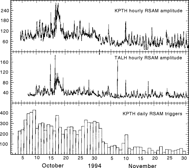 |
Figure 22. Seismicity at Rabaul (station KPTH), October-November 1994. Courtesy of RVO. |
"Before the eruption, seismic activity . . . was dominated by high-frequency earthquakes located on the caldera ring-fault system. Since the eruption, there have been few high-frequency earthquakes detected (58 in October and 37 in November, compared to normal pre-eruption levels of 200-300/month) and most of these were located away from the ring fault or in previously inactive regions of it. The level of seismicity cannot be easily compared to earlier pre-eruption levels because totally different seismic detection systems were used. However, it is believed that the level is much lower than before the eruption. This, and the fact that the majority of the epicenters are away from the ring-fault system that previously contained almost all of the seismicity, suggest that the caldera is no longer in a highly pressurized state.
"Ground deformation determined from electronic tilt meters and dry-tilt measurements indicate a reduction in the rate of deflation of the caldera since the onset of the eruption. This change is illustrated by an offshore pylon near the centre of deformation, 2 km S of Tavurvur, which subsided by 8 cm in November, compared to 18 cm in October and at least 45 cm in the last 10 days of September."
Geological Summary. The low-lying Rabaul caldera on the tip of the Gazelle Peninsula at the NE end of New Britain forms a broad sheltered harbor utilized by what was the island's largest city prior to a major eruption in 1994. The outer flanks of the asymmetrical shield volcano are formed by thick pyroclastic-flow deposits. The 8 x 14 km caldera is widely breached on the east, where its floor is flooded by Blanche Bay and was formed about 1,400 years ago. An earlier caldera-forming eruption about 7,100 years ago is thought to have originated from Tavui caldera, offshore to the north. Three small stratovolcanoes lie outside the N and NE caldera rims. Post-caldera eruptions built basaltic-to-dacitic pyroclastic cones on the caldera floor near the NE and W caldera walls. Several of these, including Vulcan cone, which was formed during a large eruption in 1878, have produced major explosive activity during historical time. A powerful explosive eruption in 1994 occurred simultaneously from Vulcan and Tavurvur volcanoes and forced the temporary abandonment of Rabaul city.
Information Contacts: B. Talai, R. Stewart, and P. de Saint-Ours, RVO.