Report on Whakaari/White Island (New Zealand) — April 1995

Bulletin of the Global Volcanism Network, vol. 20, no. 4 (April 1995)
Managing Editor: Richard Wunderman.
Whakaari/White Island (New Zealand) Currently non-eruptive but 2-year-long inflation continues
Please cite this report as:
Global Volcanism Program, 1995. Report on Whakaari/White Island (New Zealand) (Wunderman, R., ed.). Bulletin of the Global Volcanism Network, 20:4. Smithsonian Institution. https://doi.org/10.5479/si.GVP.BGVN199504-241040
Whakaari/White Island
New Zealand
37.52°S, 177.18°E; summit elev. 294 m
All times are local (unless otherwise noted)
No eruptive activity occurred during January-March 1995. Wade Crater's floor remained occupied by an aqua-blue lake; photographs taken on 11 November 1994 and 27 February 1995 disclosed a lake-level rise of ~15-20 m. The lake appeared free of convection, but did contain conspicuous orange-colored material floating on its surface. The lake surface in March was thus considerably above the floors of Wade and Princess craters.
Dominant locations of fumaroles in or adjacent to Wade Crater included those high on the W wall, on the W side of the May 1991 embayment (particularly large and conspicuous fumaroles), and NE of Wade Lake on the divide between Wade and TV1 craters.
A 4 March leveling survey had a low error of closure (<=1.5 mm). The survey detected continued uplift, apparent since at least early 1993 (figure 23), with a maximum rate of 4.8 mm/month (58 mm/year) centered about 250 m SE of the middle of Wade Crater (Peg N). An area of shorter-term relative subsidence, apparent since at least August 1994, persists in the TV1-Donald Duck Crater area.
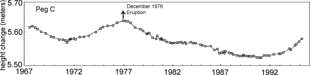 |
Figure 23. White Island deformation at leveling Peg C, ~750 m SE of the shore of Lake Wade, 1967-1995. Courtesy of IGNS. |
The magnitudes of these upward and downward motions were as follows. For the interval 21 November 1994 to 4 March 1995 the motion was 15 mm (up at Peg N) and -1 to -16 mm (down near TV1). For the interval 19 January 1994 to 4 March 1995 the motion was about 64 mm (up at peg N) and 26 mm (up near TV1).
Continued uplift of the crater floor suggested a crater-wide inflation that has been in progress for more than 2 years (figure 23). This inflation bears a close resemblance to the 5-year inflation that led up to a noteworthy eruption beginning in December 1976. An early phase of the 1976 eruption "sprinkled mustard-green colored ash" up to 1 m or more thick, over the crater and lesser thickness over the E part of the Island (SEAN 02:01).
Geological Summary. The uninhabited Whakaari/White Island is the 2 x 2.4 km emergent summit of a 16 x 18 km submarine volcano in the Bay of Plenty about 50 km offshore of North Island. The island consists of two overlapping andesitic-to-dacitic stratovolcanoes. The SE side of the crater is open at sea level, with the recent activity centered about 1 km from the shore close to the rear crater wall. Volckner Rocks, sea stacks that are remnants of a lava dome, lie 5 km NW. Descriptions of volcanism since 1826 have included intermittent moderate phreatic, phreatomagmatic, and Strombolian eruptions; activity there also forms a prominent part of Maori legends. The formation of many new vents during the 19th and 20th centuries caused rapid changes in crater floor topography. Collapse of the crater wall in 1914 produced a debris avalanche that buried buildings and workers at a sulfur-mining project. Explosive activity in December 2019 took place while tourists were present, resulting in many fatalities. The official government name Whakaari/White Island is a combination of the full Maori name of Te Puia o Whakaari ("The Dramatic Volcano") and White Island (referencing the constant steam plume) given by Captain James Cook in 1769.
Information Contacts: B.J. Scott, Institute of Geological and Nuclear Sciences (IGNS), Private Bag 2000, Wairakei, New Zealand.