Report on Kilauea (United States) — March 1996

Bulletin of the Global Volcanism Network, vol. 21, no. 3 (March 1996)
Managing Editor: Richard Wunderman.
Kilauea (United States) Heightened activity on 1-4 February followed by 10-day pause; bench construction
Please cite this report as:
Global Volcanism Program, 1996. Report on Kilauea (United States) (Wunderman, R., ed.). Bulletin of the Global Volcanism Network, 21:3. Smithsonian Institution. https://doi.org/10.5479/si.GVP.BGVN199603-332010
Kilauea
United States
19.421°N, 155.287°W; summit elev. 1222 m
All times are local (unless otherwise noted)
Unusually heightened activity along Kīlauea's East Rift zone on 1-4 February was followed by a pause that began on 4 February and ended at midnight on 14 February (BGVN 21:01). Tilt in the N-S direction increased roughly 3-fold; in the E-W direction, roughly 4-fold. Daily counts of shallow, summit SPC earthquake counts rose from around 10/day to 580/day.
During the 14-day pause, lava continued circulating inside the lava pond at Pu`u `O`o cone but no lava was seen flowing in downstream tubes. The lava pond rose to 60-70 m below the rim as the eruption restarted and lava re-entered the tubes around mid-day on 14 February.
Lava subsequently broke out of the tubes to reach the surface at numerous locations (including those at 750-, 720-, 700-, 450-, and 90-m elevations and on the coastal flats). About 31 hours later lava reached the ocean via the old tube system. Despite these numerous sites where lava had been escaping from tubes on 14-15 February, in the days following lava generally ceased reaching the surface and feeding lava flows. Lava did emerge at elevations of 60 to 100 m and on the coastal plain between Kamokuna and Kamoamoa (figure 99). The surface of the lava pond dropped by 19-21 February, possibly reaching 90 m below the rim. Still, on 23 February aa emerged at 270 m elevation. The same day, 23 February, explosive activity at the Kamokuna bench built a new littoral cone.
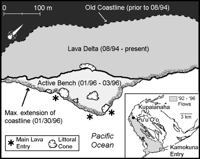 |
Figure 99. New land and active entries in the Kamokuna area, March 1996. Index map shows the swath of 1992-96 lava flows. Courtesy of HVO. |
As late as 9 March, flows confined to the area below Pulama Pali and the coast covered much of the S half of the Kamoamoa flow field but failed to reach either adjacent grasslands or the sea. During the early hours of 29 February the entire lower coastal bench, a roughly 30 x 100 m area, fell into the ocean. The event was recorded seismically at an instrument 10 km distant. Since then, freshly erupted lava began constructing a new coastal bench.
During the second half of February through early March, low-amplitude tremor in the East Rift continued; during 13-26 February and 12-25 March tremor amplitudes were ~3x background but showed fluctuations. During the February interval microearthquake counts were low beneath the summit and rift zones. Shallow, long-period microearthquake counts were high on 4-5 March and briefly again on 8 March. On 2, 5, 7, and 8 March there were four events > M 3.0 in the 7-33 km range. Deep tremor from the usual SW source was recorded in three episodes during 14-15 March: a total of 90 minutes on 14 March and 108 minutes on 15 March. Counts of shallow, long-period earthquakes increased during 19-23 March reaching a maximum daily total of 1,750.
On 24 March, 2 hours of elevated tremor (4-5x background) took place without accompanying shallow short-period earthquakes. That same day, the summit inflated rapidly for an hour and then deflated for several hours. The rate of inflation was similar to that of 1 February but the summit acquired only 3 µrads of tilt compared with the 15 µrads seen on 1 February. As the summit deflated on the afternoon of 24 March, the eruption site on the East Rift zone probably received a small magma surge resulting in moderate-sized breakouts in the early afternoon. The breakouts, which originated from the lava tube at the 820-, 750-, and near the 600-m elevations, produced small pahoehoe flows that were mostly stagnant by the next morning. On the night of the 24th, bright glow from Pu`u `O`o indicated turbulence in the lava pond. Except for these flows on 24 March, surface lavas mainly appeared below the base of Pulama Pali.
At the coast, spectacular explosions, some as high as 70 m, began on 19 March. Though diminishing thereafter, they persisted until at least 6 days. Observers saw lava bubble-bursts, lava fountains, and steam jets. These explosions built up five new littoral cones ~130 m W of the earlier Kamokuna entries inside the National Park (figure 99).
Geological Summary. Kilauea overlaps the E flank of the massive Mauna Loa shield volcano in the island of Hawaii. Eruptions are prominent in Polynesian legends; written documentation since 1820 records frequent summit and flank lava flow eruptions interspersed with periods of long-term lava lake activity at Halemaumau crater in the summit caldera until 1924. The 3 x 5 km caldera was formed in several stages about 1,500 years ago and during the 18th century; eruptions have also originated from the lengthy East and Southwest rift zones, which extend to the ocean in both directions. About 90% of the surface of the basaltic shield volcano is formed of lava flows less than about 1,100 years old; 70% of the surface is younger than 600 years. The long-term eruption from the East rift zone between 1983 and 2018 produced lava flows covering more than 100 km2, destroyed hundreds of houses, and added new coastline.
Information Contacts: Hawaiian Volcano Observatory (HVO), U.S. Geological Survey, PO Box 51, Hawaii National Park, HI 96718, USA.