Report on Kilauea (United States) — January 1998

Bulletin of the Global Volcanism Network, vol. 23, no. 1 (January 1998)
Managing Editor: Richard Wunderman.
Kilauea (United States) Surface flows; 27 January earthquake swarm
Please cite this report as:
Global Volcanism Program, 1998. Report on Kilauea (United States) (Wunderman, R., ed.). Bulletin of the Global Volcanism Network, 23:1. Smithsonian Institution. https://doi.org/10.5479/si.GVP.BGVN199801-332010
Kilauea
United States
19.421°N, 155.287°W; summit elev. 1222 m
All times are local (unless otherwise noted)
On 14 January, a surge of magma beneath Kīlauea caldera caused a rapid 2-hour inflationary pulse (BGVN 22:12). Immediately following the surge, a swarm of of M 1-2.2 earthquakes occurred at the summit and lava discharged from vents on the S side of Pu`u `O`o (17 km to the E). The surge and earthquake swarm interrupted the typical steady behavior of the 15-year eruption.
In the days following the magma surge, lava flows from Pu`u `O`o were unsteady. During 18-22 January, several surface flows of pahoehoe and aa broke from the tube system. On 20 January, a new aa flow surfaced on Pulama Pali (figure 117) at an elevation of ~500 m and flowed 2/3 of the way down the escarpment in 5 hours. On the coastal plain, pahoehoe escaped from lava tubes. The next day, parts of an access road to the Royal Gardens subdivision (figure 117) were covered by further pahoehoe flows.
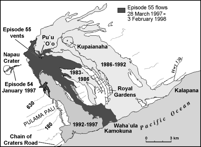 |
Figure 117. Distribution of lava flows from Kīlauea's E rift zone during 1983-98 including flows emplaced in January 1998. Contours are in meters and the contour interval is ~150 m. Courtesy of HVO. |
At the ocean, lava output was also unstable during 18-22 January. For example, lava ceased to emerge on 19 January but resumed the next day and continued through 22 January. During 14 January-3 February, Kīlauea's summit slightly inflated and deflated several times (figure 118). During this time, coincident with episodes of inflation and deflation, the lava supply to the tube system was interrupted at least twice. Consequently, the steam plumes periodically weakened and vanished for a day or two at a time. However, farther up slope magma flux through the tube system remained relatively constant, ~6 x 10⁵ m3 per day, varying by ~10% when measured over a 30-minute interval on 22 January.
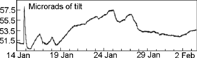 |
Figure 118. Tilt recorded on the NW edge of Kīlauea's summit during 14 January-3 February. Courtesy of HVO. |
The Pu`u `O`o vent area's appearance remained relatively unchanged in the weeks following the 14 January surge. Lava issued profusely from the crater and at vents on the S flank until about 26 January. After that until 3 February, intense fuming indicated magma degassing in the shallow subsurface, but it was visible only periodically in the vent orifices. Consequently, night glow from the Pu`u `O`o area was slight to absent.
Beginning at 1739 on 27 January and persisting into the next day, a swarm of earthquakes struck 2 km NW of the summit (beneath Namakani Paio campground). Several of these earthquakes rattled houses in the area and were felt from Hilo to Ocean View Estates, 40-50 km from the epicenter (figure 119). The largest earthquake of the sequence was M 4.4. The earthquake swarm roughly coincided with the onset of a more stable pattern of tilt at the summit.
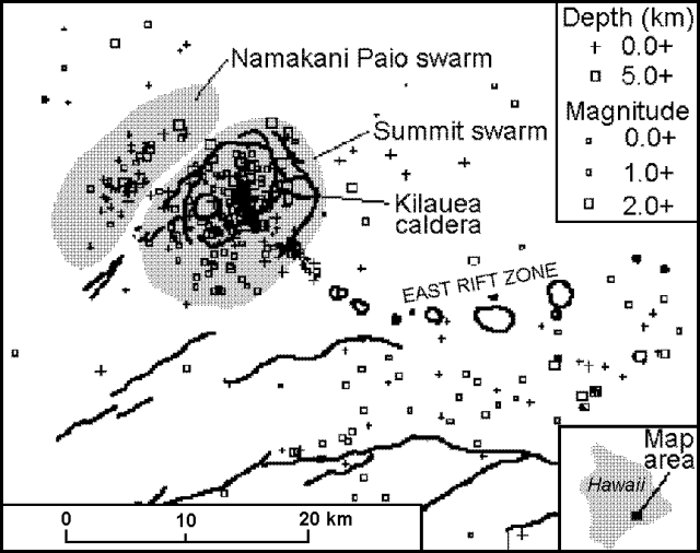 |
Figure 119. Earthquake epicenters at Kīlauea during January 1998. Heavy lines indicate faults. Courtesy of HVO. |
Kīlauea is one of five coalescing volcanoes that comprise the island of Hawaii. Historically its eruptions originated primarily from the summit caldera or along one of the lengthy E and SW rift zones that extend from the summit caldera to the sea. This latest Kīlauea eruption began in January 1983 along the E rift zone. The eruption's early phases, or episodes, occurred along a portion of the rift zone that extends from Napau Crater on the uprift end to ~8 km E on the downrift end. Activity eventually centered on what was later named Pu`u `O`o. More than 223 hectares of new land have been added to the island and local communities have suffered more than $100 million in damages since the beginning of the eruption.
Geological Summary. Kilauea overlaps the E flank of the massive Mauna Loa shield volcano in the island of Hawaii. Eruptions are prominent in Polynesian legends; written documentation since 1820 records frequent summit and flank lava flow eruptions interspersed with periods of long-term lava lake activity at Halemaumau crater in the summit caldera until 1924. The 3 x 5 km caldera was formed in several stages about 1,500 years ago and during the 18th century; eruptions have also originated from the lengthy East and Southwest rift zones, which extend to the ocean in both directions. About 90% of the surface of the basaltic shield volcano is formed of lava flows less than about 1,100 years old; 70% of the surface is younger than 600 years. The long-term eruption from the East rift zone between 1983 and 2018 produced lava flows covering more than 100 km2, destroyed hundreds of houses, and added new coastline.
Information Contacts: Hawaiian Volcano Observatory (HVO), U.S. Geological Survey, PO Box 51, Hawaii Volcanoes National Park, HI 96718, USA (URL: https://volcanoes.usgs.gov/observatories/hvo/); Ken Rubin and Mike Garcia, Hawaii Center for Volcanology, University of Hawaii, Dept. of Geology & Geophysics, 2525 Correa Rd., Honolulu, HI 96822 USA (URL: http://www.soest.hawaii.edu/GG/hcv.html).