Report on Iwatesan (Japan) — July 1998
Bulletin of the Global Volcanism Network, vol. 23, no. 7 (July 1998)
Managing Editor: Richard Wunderman.
Iwatesan (Japan) Monthly seismicity increases; volcanic history
Please cite this report as:
Global Volcanism Program, 1998. Report on Iwatesan (Japan) (Wunderman, R., ed.). Bulletin of the Global Volcanism Network, 23:7. Smithsonian Institution. https://doi.org/10.5479/si.GVP.BGVN199807-283240
Iwatesan
Japan
39.853°N, 141.001°E; summit elev. 2038 m
All times are local (unless otherwise noted)
A pattern of high seismicity but low deformation that began at Iwate in March (BGVN 23:04) continued through June and July. The following also discusses Iwate's history (as reported to JMA and Tohoku University), and details of recent hazards.
Seismicity. According to reports issued by the Japan Meteorological Agency (JMA), monthly totals of volcanic earthquake events recorded at the Matsukawa observation site of Tohoku University increased progressively: 424 in March, 764 in April, 1,283 in May, and 1,806 in June. Seismicity during 1-17 July totalled 1,116 events (figure 2).
 |
Figure 2. Numbers of earthquakes and tremors at Iwate recorded at the Matsukawa observation site at Tohoku University, 1-17 July 1998. Data courtesy of JMA. |
Low-frequency earthquakes occurred at 2124 on 23 June, and 0915 and 1037 on 24 June. A few minutes of volcanic tremor was observed at 0519 and 0701 on 24 June, and at 0754 on 25 June. Earthquake swarms below Nishi-Iwate continued to increase. (The place names Nishi- and Higashi-Iwate refer to West- and East-Iwate, respectively.) Further tremor took place at 1005 and 1642 on 27 June, and 1741 and 1759 on 28 June. Sixteen low-frequency earthquakes took place between the latter two events. Researchers at Tohoku University located these earthquakes at ~2 km SE of the summit of Higashi-Iwate at a depth of 8 km below sea level. This was close to where GPS surveys found a pressure source for crustal deformation. A swarm of low-frequency earthquake and tremor events occurred here in 1995, and it is just S of the craters of the 1732 (Yakebashiri) lava flow. Epicenters of high-frequency earthquakes were also located beneath Nishi-Iwate.
On the morning of 10 July, felt earthquakes occurred W of Iwate Volcano. Four minutes of large-amplitude tremor began at 0829 followed by a volcanic earthquake of M 2.5 at 0831. No surface phenomena were reported. Epicenters for seven earthquakes that morning were located at 3-5 km depth about 5 km west of Nishi-Iwate.
Epicenters of volcanic earthquake swarms under Nishi-Iwate migrated gradually to the W during May-June. New events occurred to the W of the swarms in July. Recent GPS measurements indicated that the source of deformation was located W of Iwate, in an area where no activity had occurred during the past 30,000 years. Although the degree of movement at stations remote from the volcano had become smaller since May, movement at stations closer to the volcano continued. Researchers believe that the source of deformation approached the surface, but they did not determine its depth.
Deformation surveys. Strain and tiltmeters at observation sites recorded little change since March. According to a field survey during 16-18 June, a fumarolic area in Nishi-Iwate seems to have been more active recently, since the fumarole temperature had increased. GPS surveys showed a steady and continuous lengthening between S and N sites of the volcano: a baseline of 9 km underwent a 5-cm extension in the last 5 months. Based on these results, volcanologists suspected a W-E dike intrusion at around 10 km below the summit of Higashi-Iwate, as opposed to just below Nishi-Iwate as indicated by earthquake swarms.
A geodetic measurement team from five Japanese national universities started a leveling survey at the E and S bases of Iwate Volcano on 17 July. The survey lines cover 19 km N-S and 15 km E-W.
History. Based on his recent field survey, Nobuo Doi, a geologist with Geothermal Engineering Co. Ltd., summarized Iwate's eruptive history. He concluded that Iwate began ~700,000 years ago. After the formation of a large cone (Nishi-Iwate), the eruption center migrated eastwards to Higashi-Iwate. Iwate collapsed to form debris avalanches seven times in the past 230,000 years; the most recent collapse took place sometime during the interval 915-1686 CE.
During a large collapse ~6,000 years ago, a mass of debris rushed NE but subsequent topographic constraints redirected debris SSE. The debris followed the Kitakami River reaching the present site of Morioka City (population 235,000). The episode left a large scar open to the NE on Higashi-Iwate's summit.
The present peak of Higashi-Iwate grew within this scar but it left part of the scar visible on its W side. During the last 6,000 years, magmatic eruptions occurred frequently; scoria eruptions have occurred more than 11 times. Lavas and pyroclastics younger than 6,000 years occur in the NE sector of Higashi-Iwate.
The 1686-87 CE eruption started with a pyroclastic surge; this was followed by scoria emission, a mudflow, a second pyroclastic surge, and it ended with a phreatic phase. In 1732, basaltic andesite lava flowed 2.5 km. Small explosions took place during 1934-35.
At Nishi-Iwate more than four phreatic eruptions have occurred in the past 7,500 years. The latest eruption here was phreatic and took place at O-Jigokudani ("large valley of hell") in 1919; an associated mudflow descended NNW.
Hazards. Authorities in two towns and villages near Iwate closed the mountain to climbers on 26 June because of the likelihood of phreatic explosions at Nishi-Iwate.
According to a local newspaper (Iwate Nippo), a new hazard map was expected to be ready for distribution on 22 July, incorporating aspects of volcanology, disaster-protection, and Sabo engineering. The scenario assumes a phreatic eruption on the W side, perhaps as large as one at Nishi-Iwate that occurred 3,200 years ago. The presumed disaster areas would be subjected to both ashfalls and lahars. A theoretical 10-cm-thick ash deposit would occur in resort areas N and S of the volcano extending to 5 km from the possible eruption site, but the researchers postulated a lack of serious damage to buildings.
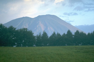
Geological Summary. Viewed from the east, Iwatesan volcano has a symmetrical profile that invites comparison with Fuji, but on the west an older cone is visible containing an oval-shaped, 1.8 x 3 km caldera. After the growth of Nishi-Iwate volcano beginning about 700,000 years ago, activity migrated eastward to form Higashi-Iwate volcano. Iwate has collapsed seven times during the past 230,000 years, most recently between 739 and 1615 CE. The dominantly basaltic summit cone of Higashi-Iwate volcano, Yakushidake, is truncated by a 500-m-wide crater. It rises well above and buries the eastern rim of the caldera, which is breached by a narrow gorge on the NW. A central cone containing a 500-m-wide crater partially filled by a lake is located in the center of the oval-shaped caldera. A young lava flow from Yakushidake descended into the caldera, and a fresh-looking lava flow from the 1732 eruption traveled down the NE flank.
Information Contacts: Nishide Noritake, Volcanological Division, Japan Meteorological Agency (JMA), 1-3-4 Ote-machi, Chiyoda-ku, Tokyo 100, Japan (URL: http://www.jma.go.jp/); Volcano Research Center, Earthquake Research Institute (ERI), University of Tokyo, Yayoi 1-1-1, Bunkyo-ku, Tokyo 113, Japan; Nobuo Doi, Geothermal Engineering Co. Ltd., Japan.