Report on Turrialba (Costa Rica) — June 1999

Bulletin of the Global Volcanism Network, vol. 24, no. 6 (June 1999)
Managing Editor: Richard Wunderman.
Turrialba (Costa Rica) A 4-fold increase in microseisms during December-April 1999
Please cite this report as:
Global Volcanism Program, 1999. Report on Turrialba (Costa Rica) (Wunderman, R., ed.). Bulletin of the Global Volcanism Network, 24:6. Smithsonian Institution. https://doi.org/10.5479/si.GVP.BGVN199906-345070
Turrialba
Costa Rica
10.025°N, 83.767°W; summit elev. 3340 m
All times are local (unless otherwise noted)
During the 17 months ending in May 1999, microseisms varied from ~30 to ~180 a month (figure 5). A 4-fold progressive increase began after December 1998.
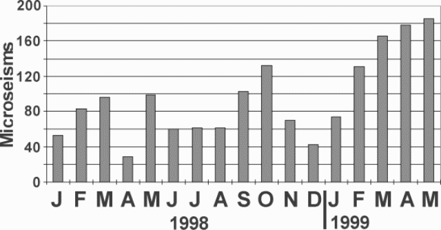 |
Figure 5. A histogram showing Turrialba's monthly microseisms during January 1998- April 1998. Courtesy of OVSICORI-UNA. |
In March 1999, the main crater's fumaroles were visible on the NE, N, NW, E and SW walls. Escaping gases appeared constant and had a temperature of 89°C. During March, the seismographic station VTU, located 0.5 km NE of the active crater registered a total of 252 earthquakes. Of those 81 had high frequency, with S-P duration of less than 1.5 seconds and frequencies greater than 3.0 Hz. The 166 microseisms registered had amplitudes under 10 mm, short durations, and frequencies between 2.1 and 3.0 Hz. An earthquake registered at 1846 on 7 March, with a Richter magnitude of 2.3, a depth of 7 km, and an epicenter 4 km NE of the main crater.
During April, the station VTU registered 287 earthquakes. Of those, 105 were of high frequency (with S-P of less than 1.5 seconds and frequencies above 3.0 Hz), and 4 were of low frequency. The 178 microseisms registered were of short duration; their dominant frequencies were between 2.1 and 3.0 Hz.
During May, a total of 309 events were recorded, of which 120 were type AB with S-P less than 1.5 seconds and frequencies less than 3.0 Hz. There were 3 low-frequency events. The 186 microseisms registered had amplitudes under 10 mm.
Geological Summary. Turrialba, the easternmost of Costa Rica's Holocene volcanoes, is a large vegetated basaltic-to-dacitic stratovolcano located across a broad saddle NE of Irazú volcano overlooking the city of Cartago. The massive edifice covers an area of 500 km2. Three well-defined craters occur at the upper SW end of a broad 800 x 2200 m summit depression that is breached to the NE. Most activity originated from the summit vent complex, but two pyroclastic cones are located on the SW flank. Five major explosive eruptions have occurred during the past 3500 years. A series of explosive eruptions during the 19th century were sometimes accompanied by pyroclastic flows. Fumarolic activity continues at the central and SW summit craters.
Information Contacts: E. Fernandez, V. Barboza, E. Duarte, R. Saenz, E. Malavassi, M. Martinez, and R. Van der Laat, T. Marino, and E. Hernandez, Observatorio Vulcanologico y Sismologico de Costa Rica, Universidad Nacional (OVSICORI-UNA), Apartado 86-3000, Heredia, Costa Rica; Wendy Perez Fernandez, Seccion de Seismologia, Vulcanologia y Exploracion Geofisica, Escuela Centroamericana de Geologia, Universidad de Costa Rica, POB 35-2060, San Jose, Costa Rica.