Report on Iwatesan (Japan) — February 2000
Bulletin of the Global Volcanism Network, vol. 25, no. 2 (February 2000)
Managing Editor: Richard Wunderman.
Iwatesan (Japan) Tremor event and earthquake swarm on 12 November 1999
Please cite this report as:
Global Volcanism Program, 2000. Report on Iwatesan (Japan) (Wunderman, R., ed.). Bulletin of the Global Volcanism Network, 25:2. Smithsonian Institution. https://doi.org/10.5479/si.GVP.BGVN200002-283240
Iwatesan
Japan
39.853°N, 141.001°E; summit elev. 2038 m
All times are local (unless otherwise noted)
At 1800 on 18 October 1999, the National Coordination Committee for Prediction of Volcanic Eruptions reported that the volcano's fumarolic area had expanded and the amount of steam had increased in the western part of Iwate volcano. New fumaroles have been observed since May on the N slopes of Mts. Ubakura-yama and Kurokura-yama and in the western stream of Ojigokudani (inside the erosion caldera). This fumarolic activity has intermittently increased since July, and ground temperatures between Mts. Kurokura-yama and Ubakura-yama also increased with time. Analyses of fumarolic gas collected between Ojigokudani and Mt. Ubakura-yama in August and October revealed a magmatic component. Although GPS measurements showed the end of the elongation trend observed since July, relatively large volcanic earthquakes occurred during May and June. Deep-seated (~30 km depth) low-frequency earthquakes, relatively deep-seated (6-13 km depth) low-frequency earthquakes, and shallow high-frequency earthquakes occurred under the eastern cone of Iwate. However, the overall level of seismicity has decreased compared to 1998 (figure 5).
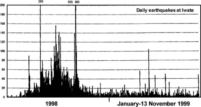 |
Figure 5. Daily numbers of earthquakes at Iwate (recorded at the Matsukawa station) during 1 January 1998-13 November 1999. Courtesy of JMA. |
On the evening of 12 November JMA issued a Volcano Advisory on Iwate after a 4-minute volcanic tremor (M 2.1) saturated local instruments starting at 2054. The event hypocenter was located 2-3 km below the Ubakura-yama and Kurokura-yama areas of western Iwate (figure 6). An earthquake swarm continued for 2 hours after the tremor event at a rate of 16-20 events/hour. Inspection from the air the following day did not show any major change in fumarolic activity or any deposition of new volcanic ash.
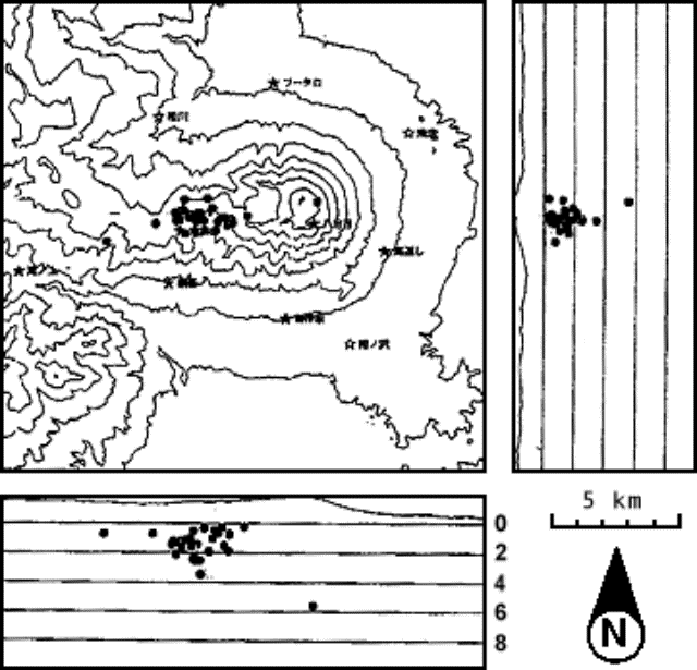 |
Figure 6. Hypocenters of earthquakes under the western section of Iwate during 11-12 November 1999. Courtesy of JMA. |
On the evening of 16 November, the extended National Coordination Committee for Prediction of Volcanic Eruptions met in the city of Morioka, Iwate Prefecture, to review the events that occurred on the 12th. They noted that the tremor was similar in shape, amplitude, and duration to one (M 2.4) that occurred on 10 July 1999; hence it was considered likely that the two events occurred in the same place. Changes detected in tilt- and strain-meters located on the flank during the tremor were probably caused by subsurface ground faulting or fluid movement. After the tremor, however, no subsequent changes were observed. Neither the GPS-based, N-S traverse distance across the volcano nor the fumarole temperatures in the Ubakura-yama to Kurokura-yama region changed before or after the event. Fumarolic activity in western Iwate had increased since May as had the number of shallow earthquakes in the Ojigokudani area (erosion caldera). The tremor event on 12 November suggested a continuing possibility of a phreatic explosions in western Iwate.
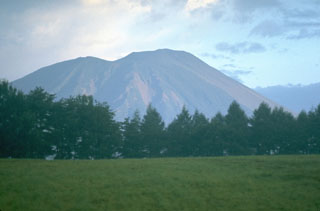
Geological Summary. Viewed from the east, Iwatesan volcano has a symmetrical profile that invites comparison with Fuji, but on the west an older cone is visible containing an oval-shaped, 1.8 x 3 km caldera. After the growth of Nishi-Iwate volcano beginning about 700,000 years ago, activity migrated eastward to form Higashi-Iwate volcano. Iwate has collapsed seven times during the past 230,000 years, most recently between 739 and 1615 CE. The dominantly basaltic summit cone of Higashi-Iwate volcano, Yakushidake, is truncated by a 500-m-wide crater. It rises well above and buries the eastern rim of the caldera, which is breached by a narrow gorge on the NW. A central cone containing a 500-m-wide crater partially filled by a lake is located in the center of the oval-shaped caldera. A young lava flow from Yakushidake descended into the caldera, and a fresh-looking lava flow from the 1732 eruption traveled down the NE flank.
Information Contacts: Kazuo Sekine, Sendai District Meteorological Observatory, Japan Meteorological Agency, 1-3-15 Gorin, Miyagino-ku, Sendai 983, Japan; Hiroyuki Hamaguchi, Faculty of Science, Tohoku University, Sendai 980-8578 Japan (URL: http://www.sci.tohoku.ac.jp/); Setsuya Nakada, Volcano Research Center, ERI, University of Tokyo, Yayoi 1-1-1, Bunkyo-ku, Tokyo 113, Japan (URL: http://www.eri.u-tokyo.ac.jp/VRC/index_E.html); Jun-ichi Hirabayashi, Kusatsu-Shirane Volcano Observatory, Tokyo Institute of Technology, Kusatsu, Agatsuma-gun, Gunma 377-17 Japan.