Report on Cleveland (United States) — January 2001
Bulletin of the Global Volcanism Network, vol. 26, no. 1 (January 2001)
Managing Editor: Richard Wunderman.
Cleveland (United States) 19 February explosion sends ash up to 10 km
Please cite this report as:
Global Volcanism Program, 2001. Report on Cleveland (United States) (Wunderman, R., ed.). Bulletin of the Global Volcanism Network, 26:1. Smithsonian Institution. https://doi.org/10.5479/si.GVP.BGVN200101-311240
Cleveland
United States
52.825°N, 169.944°W; summit elev. 1730 m
All times are local (unless otherwise noted)
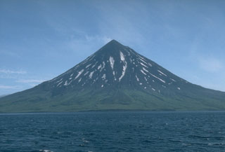
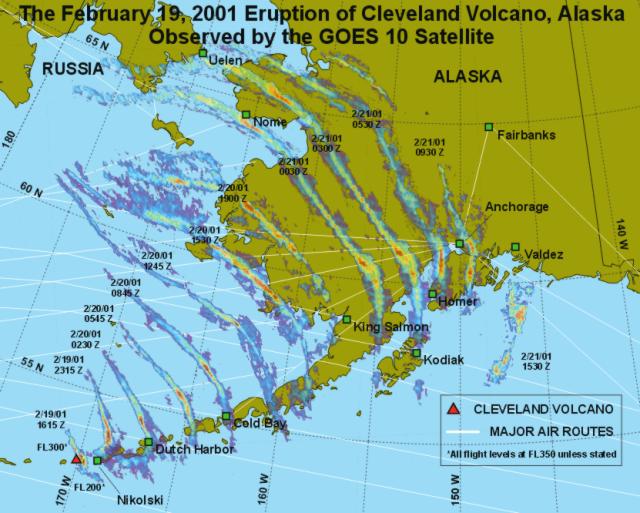
At 0600 on 19 February workers at the Alaska Volcano Observatory (AVO) using satellite imagery detected an ash cloud emanating from Cleveland volcano. The eruption was apparently explosive (figure 1). According to images captured at 0945 the ash cloud had split and drifted in two directions; one traveled 120 km SE of the volcano and reached an altitude of over 5 km, while the other cloud drifted higher, traveled 100 km N, and rose to an altitude of over 9 km (figure 2). A volcanic ash advisory was first issued at 1040 on the same day indicating that ash was being carried E at a velocity of ~55 km/hour and had reached an altitude of over 10 km. Subsequent pilot reports and satellite data revealed a diminishing intensity of the ash issuing from Cleveland, although observers in Nikolski, 72 km to the E, reported ashfall initiating at 1200 and persisting through 1600. Explosive activity ended by late afternoon.
 |
Figure 1. Cleveland on 21 February. The usually white, snow-covered flanks are shown darkened by ash from the eruption. Photo was taken by Burke Mees (PenAir pilot) and transmitted courtesy of AVO. |
AVO workers observed a persistent large thermal anomaly at the volcano, which indicated that further eruptions could occur at any time. Pilots flying near the volcano late on 21 February confirmed no further ash production, but one did observe steaming near the termination of a flow on the volcano's SW flank. The steaming was located where rubbly, apparently hot debris entered the sea, and could have been an active lava flow or a fan of debris; it likely explains the thermal anomaly detected in satellite images. A thermal anomaly continued to be detected as of 26 February, suggesting that low-level activity was still occurring. No level of concern color codes were assigned for Cleveland because AVO has no seismic monitoring stations at the volcano.
Even after the eruption ceased, the eastward drifting ash-and-steam cloud continued to be a hazard to aviators (figure 2). The SE portion of the plume approached the westernmost point of Umnak Island by 1030 on the day of the eruption, and the entire plume was carried farther E so that it reached Dutch Harbor and Akutan by 1900.
Satellite imagery at 0730 on 20 February showed the ash cloud as a band extending from S of Port Heiden to N of Nunivak Island. No ashfall was reported at Dutch Harbor, Port Heiden, or Dillingham, however.
By 0530 on 21 February the cloud could be seen on satellite imagery stretching from near Montague Island S about 150 km over the northern portion of the Gulf of Alaska. The ash band dissipated and became undetectable in satellite images by about 1700 on 21 February. A smaller ash cloud may also have drifted over interior Alaska reaching N of Fairbanks, but it became indistinguishable from weather clouds by the same time.
Reference. Miller, T.P., McGimsey, R.G., Richter, D.H., Riehle, J.R., Nye, C.J., Yount, M.E. and Dumoulin, J.A., 1998, Catalog of the historically active volcanoes of Alaska: U.S. Geological Survey Open-File Report 98-582, Alaska Volcano Observatory, Alaska, 1998. 104 p.
Geological Summary. The beautifully symmetrical Mount Cleveland stratovolcano is situated at the western end of the uninhabited Chuginadak Island. It lies SE across Carlisle Pass strait from Carlisle volcano and NE across Chuginadak Pass strait from Herbert volcano. Joined to the rest of Chuginadak Island by a low isthmus, Cleveland is the highest of the Islands of the Four Mountains group and is one of the most active of the Aleutian Islands. The native name, Chuginadak, refers to the Aleut goddess of fire, who was thought to reside on the volcano. Numerous large lava flows descend the steep-sided flanks. It is possible that some 18th-to-19th century eruptions attributed to Carlisle should be ascribed to Cleveland (Miller et al., 1998). In 1944 it produced the only known fatality from an Aleutian eruption. Recent eruptions have been characterized by short-lived explosive ash emissions, at times accompanied by lava fountaining and lava flows down the flanks.
Information Contacts: Alaska Volcano Observatory (AVO), a cooperative program of a) U.S. Geological Survey, 4200 University Drive, Anchorage, AK 99508-4667, USA (URL: http://www.avo.alaska.edu/), b) Geophysical Institute, University of Alaska, PO Box 757320, Fairbanks, AK 99775-7320, USA, and c) Alaska Division of Geological & Geophysical Surveys, 794 University Ave., Suite 200, Fairbanks, AK 99709, USA; Anchorage Volcanic Ash Advisory Center (VAAC), 6930 Sand Lake Road, Anchorage, AK 99502, USA (URL: http://vaac.arh.noaa.gov/).


