Report on Lokon-Empung (Indonesia) — November 2001
Bulletin of the Global Volcanism Network, vol. 26, no. 11 (November 2001)
Managing Editor: Richard Wunderman.
Lokon-Empung (Indonesia) March, May, and August eruptions; plumes to 1.5 km over summit
Please cite this report as:
Global Volcanism Program, 2001. Report on Lokon-Empung (Indonesia) (Wunderman, R., ed.). Bulletin of the Global Volcanism Network, 26:11. Smithsonian Institution. https://doi.org/10.5479/si.GVP.BGVN200111-266100
Lokon-Empung
Indonesia
1.358°N, 124.792°E; summit elev. 1580 m
All times are local (unless otherwise noted)
During February through at least 2 December 2001 at Lokon-Empung, seismic activity varied, three eruptions occurred, and plumes were observed rising 25-1,500 m above the summit (table 1). The volcano was at Alert Level 3 (on a scale of 1-4) until the week of 27 February - 5 March, when it was decreased to 2, remaining there through at least 2 December.
Table 1. Summary of seismicity and character of plumes at Lokon-Empung during February to 2 December 2001. At times, seismic data were not available because of a broken seismograph. During March, there were 13 deep and 12 shallow volcanic events on the 25th; there were 6 deep and 7 shallow volcanic events on the 26th. Courtesy of VSI.
| Date | Deep volcanic | Shallow volcanic | Tectonic | Tremor | Plume height above summit | Comment |
| Feb 2001 | -- | -- | 1 (M 1) | -- | 50-350 m | Thin-to-thick white plumes. |
| Mar 2001 | 21 | 19 | 32 | 5 minutes (2-16 mm amplitude) | 25-1,500 m | Thin white plumes; 26 March explosion yielded dark ash plume, ashfall. |
| Apr 2001 | 4 | 2 | 114 | Four episodes | 40-300 m | Thin white plume. |
| May 2001 | 92 | 218 | 124 | Discontinuous (0.5-7 mm amplitude) | 50-900 m | White plumes; explosion on 20 May and gray-black plume drifting N. |
| Jun 2001 | 20 | 20 | 96 | Discontinuous | 25-300 m | White plumes. |
| Jul 2001 | 162 | 263 | 134 | Discontinuous (0.5-8 mm amplitude) | 25-200 m | White plumes. |
| Aug 2001 | 57 | 261 | 45 | Discontinuous (0.5-1 mm amplitude) | 25-270 m | Thin white plume; 18 August explosion with ashfall. |
| Sep 2001 | 132 | 112 | 156 | Discontinuous | 25-250 m | Thin white plumes. |
| Oct 2001 | 48 | 165 | 82 | Discontinuous | 50-250 m | White and gray plumes. |
| Nov-2 Dec 2001 | 184 | 113 | 67 | Discontinuous | 50-250 m | White to gray plumes. |
Immediately following the 28 January eruption (BGVN 26:01), activity decreased. An M 1 tectonic earthquake was registered the week of 20-26 February. On 26 March at 1440 an eruption sent a dark ash plume 1,500 m above the crater rim that drifted E and N. No incandescent material was observed, but 25 minutes after the explosion ash started to fall at Kinilow and Kakaskasen villages (3.5 and 4 km from the crater, respectively). Activity slowly decreased though 1510, when thick white gas emissions rose 400 m above the crater. The ashfall was 0.3-0.5 cm thick at Kinilow, 0.1-0.3 cm thick at Kakaskasen, and 1-2 cm thick around the Pasahapen River ~1 km from the crater. After the initial explosion, volcanic tremor recorded between 1442 and 1457 had a maximum amplitude of 2-16 mm.
Another eruption began at 2014 on 20 May, ejecting glowing material that rose as high as 400 m and then fell around the crater. The explosion produced a gray-black plume that rose to 900 m and drifted N. At 1510, a thick-white plume reached 400 m above the summit. Based on field observations, 1-2 mm of ash was deposited in a wide area around the volcano, including Pineleng village and the provincial capital of Manado (25 km N of the volcano). In anticipation of the eruption, the Volcanological Survey of Indonesia (VSI) coordinated with local government agencies, contacted the Sam Ratulangi and Cengkareng airports, and warned people living around the volcano.
During early July, instrumental monitoring showed increased activity, based on the high number of shallow volcanic earthquakes. During 30 July-12 August seismic activity decreased. Small explosions produced plumes that rose 25-250 m above the summit.
On 18 August at 2230 an explosion produced an ash cloud that rose ~800 m above the crater and drifted over N Manado. Based on visual observations, activity did not change significantly after the explosion, but the seismicity showed a major increase. Deep and shallow volcanic earthquakes averaged 8 events per day, higher than the normal average of about 5 events per day. During July to August, seismicity decreased to nearly normal levels.
During mid-October, seismicity increased again. On 19 October an M 1 tectonic earthquake was registered, and the number of volcanic earthquakes increased significantly, followed by an interval of high-frequency tremor. Seismicity continued to increase through mid-November, to an average of 19 events per day. During the week 12-18 November, seismicity began to decrease again but still remained higher than normal, at about 10 events per day. Seismicity continued to decrease through November, and by 2 December had returned to normal levels.
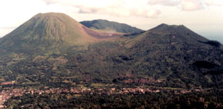
Geological Summary. The Lokong-Empung volcanic complex, rising above the plain of Tondano in North Sulawesi, includes four peaks and an active crater. Lokon, the highest peak, has a flat craterless top. The morphologically younger Empung cone 2 km NE has a 400-m-wide, 150-m-deep crater that erupted last in the 18th century. A ridge extending 3 km WNW from Lokon includes the Tatawiran and Tetempangan peaks. All eruptions since 1829 have originated from Tompaluan, a 150 x 250 m crater in the saddle between Lokon and Empung. These eruptions have primarily produced small-to-moderate ash plumes that sometimes damaged croplands and houses, but lava-dome growth and pyroclastic flows have also occurred.
Information Contacts: Dali Ahmad, Volcanological Survey of Indonesia (VSI), Jalan Diponegoro No.57, Bandung 40122, Indonesia (URL: http://www.vsi.esdm.go.id/).