Report on Kilauea (United States) — May 2003

Bulletin of the Global Volcanism Network, vol. 28, no. 5 (May 2003)
Managing Editor: Edward Venzke.
Kilauea (United States) Continued lava flows during December 2002-June 2003 enter the ocean
Please cite this report as:
Global Volcanism Program, 2003. Report on Kilauea (United States) (Venzke, E., ed.). Bulletin of the Global Volcanism Network, 28:5. Smithsonian Institution. https://doi.org/10.5479/si.GVP.BGVN200305-332010
Kilauea
United States
19.421°N, 155.287°W; summit elev. 1222 m
All times are local (unless otherwise noted)
From December 2002 through June 2003, lava from Kīlauea continued to flow down the S flanks and into the ocean at several points. Seismicity generally continued at normal (background) levels. The Mother's Day flow, which began erupting 12 May 2002, continued through June 2003 (figure 158).
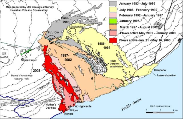 |
Figure 158. Map of lava flows erupted during 1983 through 16 May 2003 from Pu`u `O`o and Kupaianaha. The most recently active flows are on the SW side of the flow-field. Courtesy of HVO. |
Lava flows. During December 2002, lava continued to flow into the sea at entry points from two lava deltas. Moderate-to-large littoral explosions tossed spatter onto the front of the West Highcastle delta. Surface lava flows were visible on the coastal flat. On 15 December, shortly after 0700, the Wilipe'a lava delta partially collapsed, losing about 1/3 of its area. The tip of the delta retreated shoreward about 260 m and most of the collapse was in the central part of the delta. Around 15 and 16 December a substantial collapse occurred at the West Highcastle delta. On 28 December moderate collapses occurred at the Wilipe'a lava delta, apparently in the area of the 15 December collapse. Surface lava flows were visible on the coastal flat and upslope on Pulama pali.
During January and February 2003, lava continued to flow into the sea at the West Highcastle entry. Surface lava flows were visible on the coastal flat and upslope of it on Paliuli. Most of the surface lava flows on the coastal flat crusted over, so that less incandescence was visible than previously. Relatively large surface lava flows were visible starting on 21 January around 2035. Around 28 January a large lava breakout occurred from the West Highcastle lava tube about 170 m inland from the old sea cliff. As of 2 February the area of the new breakout was about 6.15 hectares (6.15 x 10⁴ m2), and surface flows and lava in lava tubes traveled down the Pulama pali fault scarp. The Chain of Craters road was closed due to a wildfire that was started by lava flows. Surface lava flows continued to travel through vegetation, igniting fires and causing methane explosions. Rangers' office huts, restrooms, and signs were moved out of the path of the lava flow, which reached the Chain of Craters Road on 19 February at 1005. Beginning 15 February and going into March, lava flowed into the sea at the Kohala entry. Fresh lava oozed out of the cooling Kohala lava flow, both within the body of the flow and along its E margin.
During 26 February to 3 March lava continued to enter the sea at the West Highcastle entry, but the lava-flow rate was reduced to a small trickle at the Kohala entry. Small surface flows occurred along the W edge of the Kohala lava flow and surface lava flows were visible above the Pulama pali fault scarp. Tongues of lava were visible traveling down Pulama pali, part of the activity that began on 12 May 2002 (named the Mother's Day flow).
Through April 2003, Kīlauea continued to erupt, sending lava down its SE flank either traveling over the land surface or through tubes. Lava entered the sea at the West Highcastle entry; activity there was sometimes weak, though one or more glowing areas were typically seen. On 16 April a large tract of land not over-run by surrounding lava (a kipuka or ahu in the local parlance) remained within the Kohola lava flow, still ~30 cm above the top of inflated lavas that surround it. On the eastern margin of the swath of lava flows going down the steep slopes of Pulama pali, one partly crusted-over lava stream was highly visible. The crater of Pu`u `O`o was dark and obscured by fumes, but eruptive activity at Pu`u `O`o continued unabated. The flows on Pulama pali were frequently visible at night as streams of incandescence from the top of the pali down to the coastal flats. Late in April, the E arm of the Mother's Day flow split in two with the W segment being more active. A new ocean entry near Lae'apuki only lasted a day before the flow stagnated. Scattered surface breakouts were seen throughout the inflating Kohola flow, especially on its W side. As of 24 April, lava entered the ocean at two points along the West Highcastle delta.
In early May, lava flows continued to descend the S flanks and pour into the sea. On 12 May lava began to enter the sea again at the West Highcastle lava delta. Surface lava flows were visible on the coastal flat and the Pulama Pali fault scarp. During June, lava continued to flow down Kīlauea's SE flank, with surface lava flows occasionally visible on the coastal flat and upslope at Pulama pali, and Paliuli. Small amounts of lava continued to flow into the sea at Highcastle beach.
Geophysical activity. During December 2002 and January 2003, seismicity was generally at normal levels. The swarm of long-period earthquakes and tremor beneath Kīlauea's caldera, occasionally seismically active since June 2002, continued to show some short bursts of tremor interspersed with small earthquakes. Small inflation and deflation events occurred at Pu`u `O`o and Uwekahuna tilt meters. The Pu`u `O`o tiltmeter showed deflation for about one week from 10 to 17 December. During 27-28 December, slight deflation occurred at the Uwekahuna and Pu`u `O`o tiltmeters.
Kīlauea's summit began to deflate on 20 January 2003 at 1710, and Pu`u `O`o began to deflate a few tens of minutes later. Both areas deflated well into the next day. On the 21st at 1610 rapid, brief inflation began at the summit. The inflation and preceding deflation were centered near the NE corner of Halemaumau Crater, the normal center of small deformation events. Seismicity increased with the deformation events, returning to normal levels afterwards. By 22 January seismicity had returned to its normal level, with the long-lasting swarm of long-period earthquakes and tremor at Kīlauea's summit continuing at weak-to-moderate levels.
During February and March, seismicity was at background levels. The long-lasting swarm of long-period earthquakes and tremor at Kīlauea's summit continued at low-to-moderate levels. On 9 and 10 February, short periods of deflation and inflation occurred at the Uwekahuna and Pu`u `O`o tiltmeters. Moderate tremor was recorded by the nearest seismometer to Pu`u `O`o until the seismometer broke on 5 March. Moderate deflation occurred on 8 March, first at the Uwekahuna tiltmeter and then at the Pu`u `O`o tiltmeter. According to a news report, a member of a tour group suffered burns on 10 March when he fell on hot lava while hiking near Chain of Craters road.
For about a week in early April, volcanic tremor at Pu`u `O`o was relatively high and small deformation changes occurred, mostly at Pu`u `O`o. During 16-17 April, the Uwekahuna tiltmeter at Kīlauea's summit recorded three small inflations, the last apparently right at its crest. Pu`u `O`o has generally followed suit, though in this case showing only two of the inflations very well. These tilts are not major but continue to illustrate the clear connection between Kīlauea's summit, where most tilt events start, and Pu`u `O`o, 20 km away, where the tilt events follow a few minutes later. Seismicity during the week was at low to normal levels. Instruments continued to register the summit swarm of long-period earthquakes and tremor, which began last June. Volcanic tremor at Pu`u `O`o remained elevated, as has been the norm for more than a week.
During 30 April to 6 May, distances measured across Kīlauea caldera between two points ~10 km apart, remained stable as they have since early 2003. There had been consistent progressive lengthening of this distance during late 2001 through mid-2002, and some minor fluctuations after that. In general, tilt during late April through 2 May changed little at Uwekahuna station (W side of the caldera), and showed a progressive decline at Pu`u `O`o station (E of the caldera). In the first few days of May slight inflationary tilt appeared at both stations.
Seismicity at Kīlauea's summit was at moderate-to-high levels from about 1 June through 14 June, with many small, low-frequency earthquakes occurring at shallow depths beneath the summit caldera. The tiny earthquakes occurred at the notably high rate of 2-4 per minute. Little or no volcanic tremor accompanied the swarm, however. Volcanic tremor at Pu`u `O`o remained moderate to high, as is the norm. A quasi-cyclic inflation and deflation occurred at Kīlauea's summit and at Pu`u `O`o during the week of 6-13 June, but did not culminate in significant overall tilt.
Geological Summary. Kilauea overlaps the E flank of the massive Mauna Loa shield volcano in the island of Hawaii. Eruptions are prominent in Polynesian legends; written documentation since 1820 records frequent summit and flank lava flow eruptions interspersed with periods of long-term lava lake activity at Halemaumau crater in the summit caldera until 1924. The 3 x 5 km caldera was formed in several stages about 1,500 years ago and during the 18th century; eruptions have also originated from the lengthy East and Southwest rift zones, which extend to the ocean in both directions. About 90% of the surface of the basaltic shield volcano is formed of lava flows less than about 1,100 years old; 70% of the surface is younger than 600 years. The long-term eruption from the East rift zone between 1983 and 2018 produced lava flows covering more than 100 km2, destroyed hundreds of houses, and added new coastline.
Information Contacts: Hawaiian Volcano Observatory (HVO), U.S. Geological Survey, PO Box 51, Hawaii National Park, HI 96718, USA (URL: https://volcanoes.usgs.gov/observatories/hvo/).