Report on Kilauea (United States) — September 2003

Bulletin of the Global Volcanism Network, vol. 28, no. 9 (September 2003)
Managing Editor: Edward Venzke.
Kilauea (United States) Active surface lava flows from June through mid-October
Please cite this report as:
Global Volcanism Program, 2003. Report on Kilauea (United States) (Venzke, E., ed.). Bulletin of the Global Volcanism Network, 28:9. Smithsonian Institution. https://doi.org/10.5479/si.GVP.BGVN200309-332010
Kilauea
United States
19.421°N, 155.287°W; summit elev. 1222 m
All times are local (unless otherwise noted)
During 2003, lava from Kīlauea continued to flow down the S flanks and into the ocean at several points. The Mother's Day flow, which began erupting from Pu`u `O`o on 12 May 2003, remained active. Seismicity generally persisted at normal (background) levels. A recent report from the U.S. Geological Survey, edited by Heliker, Swanson, and Takahashi (2003) described the nearly uninterupted Pu`u `O`o-Kupaianaha eruption that started 3 January 1983 and continues today.
Lava flows. Lava entered the sea mainly at the Highcastle ocean entry during 11-17 June and surface lava flows were visible on the coastal flat and Pulama pali during June and July 2003. However, no lava flowed into the sea during the later half of July and into early August.
Deflation that began on 8 August amounted to ~ 1.8 µrad at the Uwekahuna (UWEV) tiltmeter and ~ 4 µrad at the Pu`u `O`o tiltmeter, both located near the Kīlauea summit (figure 159). The deflation was accompanied by a drop in the level of lava in a lava tube, as seen by field workers at midday. Inflation began later that day at 1928, and in ~ 3.5 hours ~ 3.5 µrad of inflation was recorded at Uwekahuna and ~6 µrad at Pu`u `O`o.
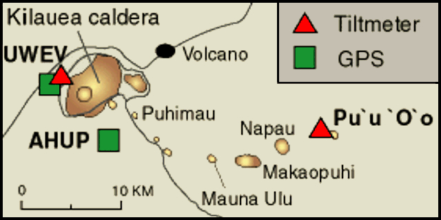 |
Figure 159. Map of selected deformation stations at Kīlauea, 2003. Courtesy of HVO. |
A lava breakout occurred on 9 August between 0200 and 0300, ~ 1.3 km SE of the center of the Pu`u `O`o cone. A very large sheet flow emerged from the up-tube side of a rootless shield formed on 21 January. Observers saw a lava stream up to 40 m wide. By 0600 the flow covered ~ 5.2 hectares (0.052 km2).
Later in August and into September, surface lava flows were visible on Kīlauea's coastal flat, in some areas flowing to within 500 m of the sea. On 2 October lava began to flow westward after filling West Gap Pit on the W flank of Pu`u `O`o cone. Fairly vigorous spattering was visible in the pit, but decreased to only sporadic bursts later in the day. The flow appeared to have stopped by 4 October when no glow was observed coming from the pit.
Lava flows have erupted from 1983 through 10 October 2003 from Pu`u `O`o and Kupaianaha. The area of recent lava flows on the W side of the flow-field has been designated the Mother's Day flow, which began erupting on 12 May 2002 and continues to the present (figure 160). Through September and into early October, lava was moving along the E and W sides of the Mother's Day flow. The E-side lava (mentioned previously as the 9 August breakout) came from the 9 August rootless shield, itself fed by the main Mother's Day tube from Pu`u `O`o. The W-side lava, known as the Kohola arm of the Mother's Day flow, branched off the tube system below the rootless shield. In early October, the E-side flow stopped moving, the W-side flow died back to a trickle, and the rootless shield gained prominence. By 16 October, however, the shield had partly collapsed, leaving several drained perched ponds. Upstream from the shield, many hornitos and small flows formed over the Mother's Day tube.
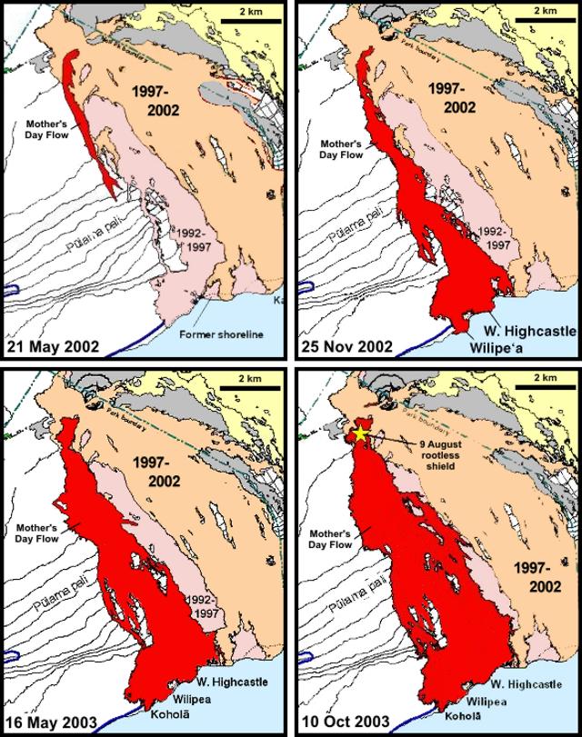 |
Figure 160. Map sequence showing Mother's Day lava flows that began on 12 May 2002 (darkest shade) from the Pu`u `O`o cone at Kīlauea as of 21 May 2002, 25 November 2002, 16 May 2003, and 10 October 2003. Modified from original maps created by the USGS Hawaiian Volcano Observatory. |
Geophysical activity. During the second half of June and into August 2003, seismicity at the summit was at moderate-to-high levels, with many small, low-frequency earthquakes occurring at shallow depths beneath the summit caldera at a rate of about 1-2 per minute. Little or no volcanic tremor accompanied the swarm at the caldera, however. Volcanic tremor at Pu`u `O`o remained at moderate-to-high levels, as is the norm. A quasi-cyclic tilt pattern ended at Kīlauea's summit and Pu`u `O`o on 13 June after lasting about a week. Small periods of inflation and deflation occurred during July and into August.
During the deflation on 8 August, there was an increase in small, low-frequency earthquakes and changes in their frequency content. Some larger events occurred at depths of a few kilometers, as during the previous several weeks. A magnitude 5.0 earthquake 10 km beneath Kīlauea's central S flank on 26 August at 2024 was the largest since 2 April 2000, which occurred in almost exactly the same spot. No significant damage was done, no cracks or rockfalls were seen, and there was no change in the eruption. Generally, following that event and into September, summit seismicity continued at moderate levels with 1-2 small low-frequency earthquakes per minute occurring at shallow depths beneath the summit caldera. There were some larger events at depths of a few kilometers.
At about 1500 on 20 September 2003, first Uwekahuna and then Pu'u O'o started to deflate. Pu'u O'o lost ~ 1.5 µrad during the deflation, and Uwekahuna lost ~ 0.9 µrad. The deflation ended with a sharp inflation in the early morning on 21 September, which lasted until early on 22 September, when the tilt flattened.
Reference. Heliker, C., Swanson, D.A., and Takahashi, T.J. (eds), 2003, The Pu`u `O`o-Kupaianaha eruption of Kīlauea Volcano, Hawaii: The first 20 years: U.S. Geological Survey Professional Paper 1676, Denver, CO.
Geological Summary. Kilauea overlaps the E flank of the massive Mauna Loa shield volcano in the island of Hawaii. Eruptions are prominent in Polynesian legends; written documentation since 1820 records frequent summit and flank lava flow eruptions interspersed with periods of long-term lava lake activity at Halemaumau crater in the summit caldera until 1924. The 3 x 5 km caldera was formed in several stages about 1,500 years ago and during the 18th century; eruptions have also originated from the lengthy East and Southwest rift zones, which extend to the ocean in both directions. About 90% of the surface of the basaltic shield volcano is formed of lava flows less than about 1,100 years old; 70% of the surface is younger than 600 years. The long-term eruption from the East rift zone between 1983 and 2018 produced lava flows covering more than 100 km2, destroyed hundreds of houses, and added new coastline.
Information Contacts: Hawaiian Volcano Observatory (HVO), U.S. Geological Survey, PO Box 51, Hawaii National Park, HI 96718, USA (URL: https://volcanoes.usgs.gov/observatories/hvo/).