Report on Kilauea (United States) — September 2004

Bulletin of the Global Volcanism Network, vol. 29, no. 9 (September 2004)
Managing Editor: Richard Wunderman.
Kilauea (United States) June-October 2004 period has lava entering ocean and ample lava flows
Please cite this report as:
Global Volcanism Program, 2004. Report on Kilauea (United States) (Wunderman, R., ed.). Bulletin of the Global Volcanism Network, 29:9. Smithsonian Institution. https://doi.org/10.5479/si.GVP.BGVN200409-332010
Kilauea
United States
19.421°N, 155.287°W; summit elev. 1222 m
All times are local (unless otherwise noted)
Scientists at the Hawaiian Volcano Observatory (HVO) noted that throughout June and July 2004, lava from Kīlauea continued to enter the ocean at several points, culminating in several new lava deltas. Some small littoral explosions were reported, but otherwise the ocean entry was passive. Many small lava flows were observed in the area of the ocean entries, on the coastal flat, in the Paliuli area, and in the Kuhio area. Incandescence and some minor spattering was observed at Pu`u `O`o throughout the week. On 13 June, two collapses occurred at Kīlauea's western lava delta, sending sizable chunks of the delta into the sea.
On 14 June, most lava was being supplied to the ocean through lava tubes, but several surface lava flows were visible on the delta and traveling down the old sea cliff behind the Wilipe`a delta. The larger eastern lava delta had several active lava entries into the ocean, mostly larger than those on the western delta. Seismicity at Pu`u `O`o was moderate to high, but the overall seismicity at Kīlauea was low. Several episodes of inflation and deflation were recorded. Relatively large deflation events occurred on 29 June and 11 July, with no obvious accompanying changes in eruptive activity. An episode of deformation consisting of deflation, inflation, then deflation began at Kīlauea on the morning of 27 July. It was accompanied by increased surface activity at several places. During inflation, seismicity greatly increased below Kīlauea's caldera. Field observers reported that deformation may have occurred at the S flank of Pu`u `O`o. Aside from the deflation-inflation-deflation event, seismicity was weak beneath Kīlauea's summit and tremor at Pu`u `O`o was at moderate-to-high levels.
During August and September 2004, no lava entered the sea. Surface lava flows were active on the coastal flat and the Pulama pali fault scarp, and the vents in the crater of Pu`u `O`o were incandescent. Seismicity was weak beneath Kīlauea's summit and tremor was at moderate-to-high levels at Pu`u `O`o. In addition, there were small periods of inflation and deflation. HVO scientists reported that all vents in Pu`u `O`o's crater were incandescent during parts of both August and September.
From 30 September to 18 October 2004, patches of incandescence were visible at the PKK lava flow on the Pulama pali scarp, and all vents in the crater of Pu`u `O`o were incandescent. Seismicity was weak at Kīlauea's summit, with essentially no tremor recorded. An M 4.0 earthquake occurred on 11 October. It was focused ~ 32 km beneath Kīlauea's summit and affected tilt meters. Taking earthquake- and rainfall-induced tilts into account, the volcanic tilt was minor. On 13 October 2004 an M 4.5 earthquake occurred at 1318 ~ 6 km S of Pu`u `O`o at a depth of ~ 9 km. The earthquake permanently offset the Pu`u `O`o tiltmeter and several others on the volcano. Tremor was moderate at Pu`u `O`o. In addition, small amounts of inflation and deflation occurred.
On the morning of 24 October 2004 HVO scientists noted activity at that the three arms of the PKK flow (the Kuhio flow, named for Prince Kuhio Kalaniana`ole). Largest and most vigorous, the W arm descended down to an elevation of ~ 200 m, well out onto the gentle slope below Pulama pali. A series of channels and incandescent fingers were visible along a 600-m-long stretch, and tiny spots marked the upstream course of the arm, roughly following the E side of the Mother's Day flow.
The middle arm had advanced 100-200 m since the previous morning (23 October) and reached down to an elevation of ~ 335 m. It was the smallest of the three active arms.
The E arm was quite active that morning, its front also located on the gentle slope below Pulama pali at ~ 300 m elevation; it was nearly continuously incandescent up to ~ 440 m elevation. The distance between the W and middle arms was about 400 m and between the middle and E arms, about 600 m. These distances changed constantly as flows widen and narrow. Figures 167 and 168 show lava flows since 1983 to aid the reader in locating features discussed in this Bulletin report.
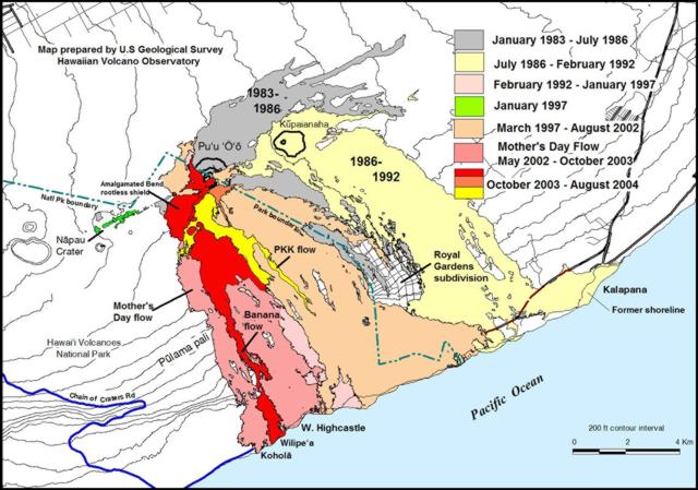 |
Figure 167. Map of lava flows from Pu`u `O`o and Kupaianaha from 1983 to 24 August 2004. Features shown include the Mother's Day flow field, which began erupting on 12 May 2002 and continues to the present. Lava flows erupted during November 2003-24 August 2004 include the Banana flow, which developed gradually starting in the middle of April. The MLK flow, located just S of the Pu`u `O`o vent, erupted in January and, in brief subsequent spurts. The Kuhio (PKK) flow was active most of the time from 20 March to 24 August 2004. As of 24 August, most activity was located in the Banana flow, fed by the Banana branch of the Mother's Day tube. The PKK flow also remained active. Courtesy of U.S. Geological Survey Hawaiian Volcano Observatory. |
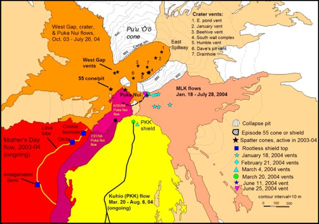 |
Figure 168. Map of Pu`u `O`o and vicinity as of 24 August 2004 showing vents, lava flows, and other features near Pu`u `O`o. The West Gap cones are just outside the boundary of the crater—the oval-shaped depression containing the seven numbered vents (now down to six after Humble Vent was buried by lava flows erupted from Dave's Pit/Vent in March). The Mother's Day flows in the lower left have been erupted since 12 May 2002. Other flow areas are labeled accordingly with names and dates of activity. Light shading indicates episode-55 flows erupted between March 1997 and August 2002. Courtesy of U.S. Geological Survey, Hawaiian Volcano Observatory. |
Moderately bright glow came from the 640- to 670-m elevations farther upstream in the PKK flow. All vents in Pu`u `O`o's crater were incandescent on 24 October, creating a glow visible from several distant places. Seismicity was weak at Kīlauea's summit, with essentially no tremor recorded. Tremor was moderate at Pu`u `O`o. Kīlauea's summit deflated moderately during 23 October and then took a plunge during the middle of the night. It lost about 0.3 microradians before the plunge began just before midnight, and it lost another 0.5 microradians thereafter. Pu`u `O`o, too, was deflating rapidly, shifting up and down a little but maintaining an overall flat tilt until the plunge began. It also lost about 0.5 microradians after midnight.
Geological Summary. Kilauea overlaps the E flank of the massive Mauna Loa shield volcano in the island of Hawaii. Eruptions are prominent in Polynesian legends; written documentation since 1820 records frequent summit and flank lava flow eruptions interspersed with periods of long-term lava lake activity at Halemaumau crater in the summit caldera until 1924. The 3 x 5 km caldera was formed in several stages about 1,500 years ago and during the 18th century; eruptions have also originated from the lengthy East and Southwest rift zones, which extend to the ocean in both directions. About 90% of the surface of the basaltic shield volcano is formed of lava flows less than about 1,100 years old; 70% of the surface is younger than 600 years. The long-term eruption from the East rift zone between 1983 and 2018 produced lava flows covering more than 100 km2, destroyed hundreds of houses, and added new coastline.
Information Contacts: Hawaiian Volcano Observatory (HVO), U.S. Geological Survey, PO Box 51, Hawaii National Park, HI 96718, USA (URL: https://volcanoes.usgs.gov/observatories/hvo/).