Report on Kilauea (United States) — October 2006

Bulletin of the Global Volcanism Network, vol. 31, no. 10 (October 2006)
Managing Editor: Richard Wunderman.
Kilauea (United States) PKK lava tube active August-November 2006; 10 October collapse pit at Pu`u `O`o
Please cite this report as:
Global Volcanism Program, 2006. Report on Kilauea (United States) (Wunderman, R., ed.). Bulletin of the Global Volcanism Network, 31:10. Smithsonian Institution. https://doi.org/10.5479/si.GVP.BGVN200610-332010
Kilauea
United States
19.421°N, 155.287°W; summit elev. 1222 m
All times are local (unless otherwise noted)
-Lava from Kīlauea continued to flow through the PKK lava tube from its source at Pu`u `O`o to the ocean during this reporting period from late August to the end of November 2006. About 1 km S of Pu`u `O`o, the Campout lava flow branches off from the PKK tube. Through November, the PKK and Campout systems fed two widely separated ocean entries named East Lae`apuki and East Ka`ili`ili, respectively. Kīlauea's activity during this reporting period included numerous small breakouts from the Campout flow, new skylights along the PKK tube, and variable activity at the ocean entries, including small streams of lava crossing the coastal bench. Intermittant lava fountaining 15 m inland of the W edge of the East Lae`apuki bench was noted in late September-early October. Incandescence was also intermittently visible coming from the East Pond and January vents, the South Wall complex, and the Drainhole vent in Pu`u `O`o's crater. In general, during this reporting period the inflationary trend continued at the summit of Kīlauea, in areas S of Halema`uma`u crater and tremors remained at a very typical moderate level at Pu`u `O`o.
During 30 August-12 September, crews reported visible lava streams on the W side of the East Lae'apuki delta and occasionally from the East Ka'ili'ili entry. On 1 September, the East Lae'apuki lava bench was an estimated 22 hectares (54 acres) and East Ka`ili`ili was an estimated 2.3 hectares (5.8 acres). On 30 August, and 1 and 6 September, the Campout flow escaped from the PKK tube. On 11 September, Park Service field crews reported two lava flows visible down the entire length of the pali. Incandescence was intermittently visible from the East Pond and January vents, the South Wall complex, and the Drainhole vent in Pu`u `O`o's crater.
During 13-23 September, lava from the Campout and PKK systems continued to flow off of a lava delta into the ocean and breakout flows were visible on the pali. On 20 September, a tour pilot reported seeing three large lava flows from a breakout 10 m inland from the old sea cliff at East Lae`apuki (figures 180 and 181). On 23 September, incandescence from above Pulama pali in the direction of Pu`u`O`o was likely due to several new and reactivated skylights on the upper PKK tube.
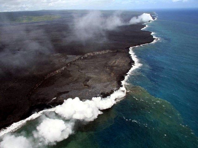 |
Figure 180. Aerial view of the lava bench at East Lae`apuki, looking NE on 20 September 2006. An active lava flow is going over the sea cliff in roughly the center of the arcuate fault scarp in the widest part of the lava bench below it. White steam plumes from the ocean entry were blown towards along the coast towards the left. In the colored version of this shot the adjacent seawater contains a greenish hue. Courtesy of HVO. |
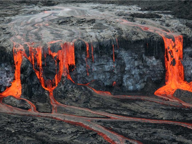 |
Figure 181. A lava flow at Kīlauea breaks out to the surface 10 m inland from a sea cliff on 20 September 2006 . The lava pours over the cliff in places as thick curtains and elsewhere as smaller rivulets and dripping falls. After the fall the lava proceeded across the upper bench as a series of braided streams. Toward the left, some readers might claim they see a slender Pelé, dancing with arms upraised. Courtesy of HVO. |
Littoral fountaining on 27 September was reported about 15 m inland of the W edge of the East Lae`apuki bench. Lava jetted about 30 m in the air accompanied by loud rumbling and jetting sounds. Observers reported ground shaking. Over the next couple of days, 3-4 lava streams were visible on the W side of East Lae`apuki entry, as were incidents of tephra jetting and lava fountaining 15-23 m (50-75 ft) high. Glow had been visible from the East Lae`apuki entry and the Campout flow breakout on the pali, but not from the Ka`ili`ili entry. The consistent lack of visible glow from the Ka`ili`ili entry was due to the absence of a very large bench, forcing lava to remain hidden at the base of the seacliff.
Observers reported that on 28 September the floor of the Drainhole vent had been replaced by an overturning lava pond. As of 29 September, a new tube and flow that formed on the E side of the Campout flow extended ~ 180 m. Another flow went W and butted up against the PKK tube. The USGS field crew also found a small stagnant breakout of lava at ~ 60 m elevation. It flowed E to cover a little more of the long-abandoned Royal Gardens subdivision. In the Pu'u O'o vicinity, a new collapse pit photographed in early October had engulfed pre-existing spatter cones (figure 182).
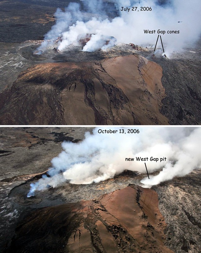 |
Figure 182. Two views of Kīlauea's W gap area illustrating morphologic changes there. (top) Aerial view of Pu`u `O`o taken in July 2006 shows two spatter cones.. Note helicopter above label for scale. (bottom) An aerial photo taken on 13 October 2006 shows a new collapse pit that grew to engulf the spatter cones. The bottom of the pit, which formed on the night of 10 October, is hidden by fume. Courtesy of HVO. |
During October and November, breakout flows were intermittently visible on the Pulama pali, at the base of the pali, or on the sea cliff and incandescence from vents in Pu`u`O`o was visible. For example, on 25 October, two separate break-out lava flows were visible on pali. The upper flow at about 320 m (1,050 ft) elevation consisted of 'a'a and pahoehoe and the lower flow at 114 m (375 ft) was solely pahoehoe. On 3 and 4 November, tephra jetted at the tip of the East Lae`apuki bench. On 15 November, breakouts resumed on top of the seacliff after a few weeks without activity. On 18 November, the Drainhole vent twice ejected spatter as high as 25 m above its rim. On 19 November, observers saw small explosions at East Lae`apuki ocean entry as well as well-defined streams of lava entering the ocean. The next evening, six rivers of lava flowed over the bench and into the ocean at the W entry. When weather permitted, incandescence was visible from the East Pond, the South Wall complex, the January vents, and Drainhole vent.
Geological Summary. Kilauea overlaps the E flank of the massive Mauna Loa shield volcano in the island of Hawaii. Eruptions are prominent in Polynesian legends; written documentation since 1820 records frequent summit and flank lava flow eruptions interspersed with periods of long-term lava lake activity at Halemaumau crater in the summit caldera until 1924. The 3 x 5 km caldera was formed in several stages about 1,500 years ago and during the 18th century; eruptions have also originated from the lengthy East and Southwest rift zones, which extend to the ocean in both directions. About 90% of the surface of the basaltic shield volcano is formed of lava flows less than about 1,100 years old; 70% of the surface is younger than 600 years. The long-term eruption from the East rift zone between 1983 and 2018 produced lava flows covering more than 100 km2, destroyed hundreds of houses, and added new coastline.
Information Contacts: Hawaiian Volcano Observatory (HVO), U.S. Geological Survey, PO Box 51, Hawaii National Park, HI 96718, USA (URL: https://volcanoes.usgs.gov/observatories/hvo/).