Report on Saunders (United Kingdom) — October 2006
Bulletin of the Global Volcanism Network, vol. 31, no. 10 (October 2006)
Managing Editor: Richard Wunderman.
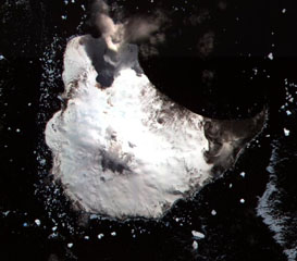
Saunders (United Kingdom) Clear IR satellite view on 28 October 2006 suggests lava inside the crater
Please cite this report as:
Global Volcanism Program, 2006. Report on Saunders (United Kingdom) (Wunderman, R., ed.). Bulletin of the Global Volcanism Network, 31:10. Smithsonian Institution. https://doi.org/10.5479/si.GVP.BGVN200610-390090
Saunders
United Kingdom
57.8°S, 26.483°W; summit elev. 843 m
All times are local (unless otherwise noted)
Matt Patrick sent a new Advanced Spaceborne Thermal Emission and Reflection Radiometer (ASTER) image, collected 28 October 2006 over Saunders Island . In his opinion this is the best image collected to date owing to the lack of a plume obscuring the summit crater, which was a problem in all previous images. The improved image provides a clear view of the crater (figures 5 and 6).
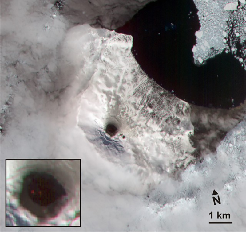 |
Figure 5. An ASTER image of Mt. Michael created using energy in the visible near-infrared wavelength ("VNIR"; bands 3-2-1, RGB), with the inset showing a closer view of the summit crater. There are two small near-IR anomalies (band 3, 0.807 microns wavelength) in the otherwise dark center of the crater, shown as red spots in the colored image. The two anomalies suggest very high temperatures and support the idea that fresh lava may reside at the surface or a shallow level in the crater. Courtesy of Matt Patrick. |
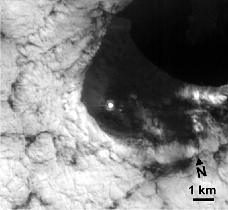 |
Figure 6. The ASTER Short Wave Infrared (SWIR; band 9, 2.4 microns) image with a conspicuous anomaly at the summit, with numerous saturated pixels. Courtesy of Matt Patrick. |
Analyzing the VNIR, SWIR, and Thermal Infrared (TIR) (not shown in figures 5 or 6) images together shows that the outer crater is 500-600 m wide, with a 180m high-temperature crater interior. The latter shows up as an SWIR anomaly and may indicate the rough extent of active lava flow being ~ 180 m wide. Matt Patrick chose Villarrica volcano in Chile for comparison to Mt. Michael (figure 7) since it presents a potentially good analogue in terms of morphology and activity style. Maximum radiant heat flux values were similar (up to ~ 150 MW), suggesting that the maximum intensity of activity may be similar. Mt. Michael shows a much lower frequency of thermal alerts, which may be the result of more frequent cloud cover in the South Sandwich Islands or a greater depth to molten lava in the Mt. Michael crater.
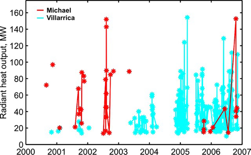 |
Figure 7. The real-time satellite thermal monitoring (MODVOLC) radiant heat flux values for Michael and Villarrica volcanoes during the period 2000-11 November 2006. Courtesy of Matt Patrick. |
Table 1 shows a summary of thermal anomalies and possible eruptions from Moderate Resolution Imagine Spectroradiometer (MODIS) satellites since November 2005. The last reported activity of Mount Michael was noted in the SI/USGS (Smithsonian Institution/U.S. Geological Survey) Weekly Volcanic Activity Report of 12-18 October 2005 (see BGVN 31:04). At that time the first MODVOLC alerts for the volcano since May 2003 indicated an increased level of activity in the island's summit crater and a presumed semi-permanent lava lake that appeared confined to the summit crater. Those alerts occurred on 3, 5, and 6 October 2005.
Table 1. Thermal anomalies measured by MODIS satellites for Mount Michael for the period 3 October 2005 to 1 November 2006. All of the anomalies appeared on the SW side of the volcano. Courtesy of Hawai'i Institute of Geophysics and Planetology (HIGP) Thermal Alerts Team.
| Date | Time (UTC) | Number of pixels | Satellite |
| 01 Nov 2006 | 0125 | 1 | Terra |
| 31 Oct 2006 | 1600 | 1 | Aqua |
| 21 Oct 2006 | 1120 | 1 | Terra |
| 20 Oct 2006 | 0250 | 2 | Aqua |
| 20 Oct 2006 | 0100 | 3 | Terra |
| 21 Jul 2006 | 0120 | 1 | Terra |
| 09 Jun 2006 | 0920 | 2 | Aqua |
| 21 Jan 2006 | 0100 | 1 | Terra |
| 20 Dec 2005 | 0100 | 1 | Terra |
| 06 Oct 2005 | 0115 | 1 | Terra |
| 05 Oct 2005 | 0220 | 1 | Aqua |
| 03 Oct 2005 | 0045 | 1 | Terra |
References. Lachlan-Cope, T., Smellie, J.L., and Ladkin, R., 2001, Discovery of a recurrent lava lake on Saunders island (South Sandwich Islands) using AVHRR imagery: Journal of Volcanology and Geothermal Research, vol. 112, no. 1-4, p. 105-116 (authors are members of the British Antarctic Survey).
LeMasurier, W.E., and Thomson, J.W. (eds), 1990, Volcanoes of the Antarctic Plate and Southern Oceans: American Geophysical Union, Washington, D.C., AGU Monograph, Antarctic Research Series, v. 48.
Geological Summary. Saunders Island consists of a large central volcanic edifice intersected by two seamount chains, as shown by bathymetric mapping (Leat et al., 2013). The young Mount Michael stratovolcano dominates the glacier-covered island, while two submarine plateaus, Harpers Bank and Saunders Bank, extend north. The symmetrical Michael has a 500-m-wide summit crater and a remnant of a somma rim to the SE. Tephra layers visible in ice cliffs surrounding the island are evidence of recent eruptions. Ash clouds were reported from the summit crater in 1819, and an effusive eruption was inferred to have occurred from a N-flank fissure around the end of the 19th century and beginning of the 20th century. A low ice-free lava platform, Blackstone Plain, is located on the north coast, surrounding a group of former sea stacks. A cluster of cones on the SE flank, the Ashen Hills, appear to have been modified since 1820 (LeMasurier and Thomson, 1990). Analysis of satellite imagery available since 1989 (Gray et al., 2019; MODVOLC) suggests frequent eruptive activity (when weather conditions allow), volcanic clouds, steam plumes, and thermal anomalies indicative of a persistent, or at least frequently active, lava lake in the summit crater. Due to this observational bias, there has been a presumption when defining eruptive periods that activity has been ongoing unless there is no evidence for at least 10 months.
Information Contacts: Matt Patrick, Michigan Technological University, Houghton, MI; Thermal Alerts Team, Hawai'i Institute of Geophysics and Planetology (HIGP), School of Ocean and Earth Science and Technology (SOEST), University of Hawai'i, 2525 Correa Road, Honolulu, HI 96822, USA (URL: http://modis.higp.hawaii.edu/); John Smellie, British Antarctic Survey, Natural Environment Research Council, High Cross, Madingly Road, Cambridge CB3 0ET, United Kingdom (URL: https://www.bas.ac.uk/); ASTER Science Project Teams, United States and Japan (URL: https://asterweb.jpl.nasa.gov/).