Report on Macdonald (France) — January 2007

Bulletin of the Global Volcanism Network, vol. 32, no. 1 (January 2007)
Managing Editor: Richard Wunderman.
Macdonald (France) Swarm of T-wave events during October 2005
Please cite this report as:
Global Volcanism Program, 2007. Report on Macdonald (France) (Wunderman, R., ed.). Bulletin of the Global Volcanism Network, 32:1. Smithsonian Institution. https://doi.org/10.5479/si.GVP.BGVN200701-333060
Macdonald
France
28.98°S, 140.25°W; summit elev. -39 m
All times are local (unless otherwise noted)
After more than 17-years in quiescence, Macdonald seamount entered into a short phase of hydroacoustic activity starting at 1400 UTC on 13 October 2005. The seamount is ~ 6,000 km S of Honolulu, Hawaii (figure 2). When hydroacoustic activity has been of sufficient amplitude and duration, it has often been inferred to suggest submarine eruptions. In this case the signals were relatively weak and of modest duration, indicating seismic swarms without a clear association with volcanism.
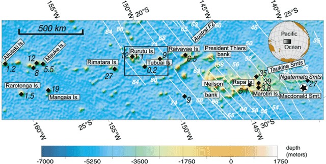 |
Figure 2. Shaded view of seafloor topography for the Cook-Austral island chains (see upper inset for location). Map projection is made along direction of the present motion of Pacific plate (which moves from right to the left). White lines correspond to crustal magnetic anomalies, and their corresponding ages, in millions of years (Ma), are in white numerals. Black diamonds represent places where K-Ar or Ar/Ar ages are known. These ages, in Ma, are printed in black. From A. Bonneville (undated, post-2002 website, see References below). |
Over five days the Polynesian Seismic Network (RSP for Réseau Sismique Polynésien) recorded 423 small- and medium-amplitude T-wave events from the seamount (figure 3). The best inland seismic station recording the event was at East Tuamotu, ~ 750 km from Macdonald. The ground response there was in the range of 50-300 nanometers.
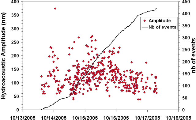 |
Figure 3. A plot of the cumulative number and amplitude of T-wave events from Macdonald seamount during 13-17 October 2005. The x-axis shows the date. The y-axis scale is on the right and indicates the cumulative number of events (for the curve labeled Nb), which ultimately totaled 423. The y-axis scale is on the left and gives the amplitudes of ground motion for each of the 423 events (diamonds, some of which may be superimposed). Courtesy of Dominique Reymond and Olivier Hyvernaud, Laboratoire de Géophysique, CEA/DASE/LDG, Tahiti. |
According to Robert Dziak, hundreds of medium to large amplitude T-wave events were also recorded on the NOAA/PMEL hydrophone array in the eastern Equatorial Pacific located some 2,200 km away from Macdonald. There was an absence of Pn and Sn seismic phases (the P- and S-wave phases that propagate at the base of ocean crust along the Moho discontinuity) suggesting the swarm was composed of comparatively low-magnitude events. Accordingly, geophysicists from both the RSP and NOAA/PMEL all interpreted the activity as a modest seismic swarm.
Many of the October 2005 T-wave signals were well located, with an error ellipse of less than 1 km in diameter. The strongest signals were seen on Tahiti, Rangiroa, and parts of the East Tuamotu networks; and consequently, these yielded the smaller error ellipses. The weakest T waves were seen on parts of the East Tuamotu network, resulting in the large NE-trending error ellipses.
The signals stopped at 0700 UTC on 17 October 2005. Dominique Reymond and Olivier Hyvernaud of the RSP were not aware of any witnessed eruptive signs or any detected hydroacoustic activity at or near Macdonald following the 2005 episode through 2006.
Additional research. Our previous reports on Macdonald seamount discussed activity during the 1980s, most recently during January 1989 (SEAN 14:01). Since then, several papers have shed light on the region (including Stoffers and others, 1989; McNutt and others, 1997; Sleep, 1997). McNutt and others (1997) presented high-resolution swath bathymetry in the Southern Austral islands, and noted more than one lone seamount in the area of Macdonald.The seamounts at Macdonald were morphologically distinct from their neighbors to the W along the Austral island chain in both their tall form and their slopes, which curved concave-upward.
References. Bonneville, A., (undated-post 2002), The Cook-Austral volcanic chain, URL: http://www.mantleplumes.org/Cook-Austral.html.
McNutt, M.K., Caress, D.W. Reynolds, J., Jordahl1, K.A., and Duncan, R.A., 1997, Failure of plume theory to explain midplate volcanism in the southern Austral islands: Nature, v. 389, p. 479-482.
Sleep, N., 1997 (2 October), Earth Science: The puzzle of the South Pacific: Nature, v. 389, p. 439-440.
Stoffers, P., Botz1, R., Cheminée, J-L., Devey, C.W., Froger, V., Glasby, G.P., Hartmann, M., Hékinian, R., Kögler, F., Laschek, D., Larqué, P., Michaelis, W., M?he1, R.K., Puteanus, D., and Richnow, H.H., 1989, Geology of Macdonald Seamount region, Austral Islands: Recent hotspot volcanism in the south Pacific: Journal Marine Geophysical Researches, v. 11, no. 2/June, p. 101-112.
Geological Summary. Discovered by the detection of teleseismic waves in 1967, Macdonald seamount (also known as Tamarii seamount) rises from a depth of about 1,800 m to within 27 m of the ocean surface at the eastern end of the Austral Islands. The basaltic submarine volcano marks the site of a hotspot that was the source of the Austral-Cook island chain. The summit, named after volcanologist Gordon Macdonald, consists of a flat plateau about 100 x 150 m wide with an average depth of about 40 m. The summit plateau is capped with spatter cones that form steep-sided pinnacles. Most eruptions have been seismically detected, but in 1987 and 1989 pumice emission was observed from research vessels. Pumice rafts observed in the South Pacific in 1928 and 1936 may also have originated here.
Information Contacts: Dominique Reymond and Olivier Hyvernaud, Laboratoire de Géophysique, Commissariat a l'Energie Atomique, CEA/DASE/LDG, PO Box 640, Papeete, Tahiti, French Polynesia; Robert P. Dziak, Oregon State University, 2115 SE OSU Drive Newport OR 97365, USA.