Report on Ijen (Indonesia) — February 2007

Bulletin of the Global Volcanism Network, vol. 32, no. 2 (February 2007)
Managing Editor: Richard Wunderman.
Ijen (Indonesia) Acidic crater lake and active solfatara investigations
Please cite this report as:
Global Volcanism Program, 2007. Report on Ijen (Indonesia) (Wunderman, R., ed.). Bulletin of the Global Volcanism Network, 32:2. Smithsonian Institution. https://doi.org/10.5479/si.GVP.BGVN200702-263350
Ijen
Indonesia
8.058°S, 114.242°E; summit elev. 2769 m
All times are local (unless otherwise noted)
Scientists from Simon Fraser and McGill universities conducted preliminary geophysical and geochemical field studies at Ijen (figure 4) between 13 and 26 August 2006. During this period, volcanic activity was low and restricted to persistent degassing of the solfatara in the SE part of the crater.
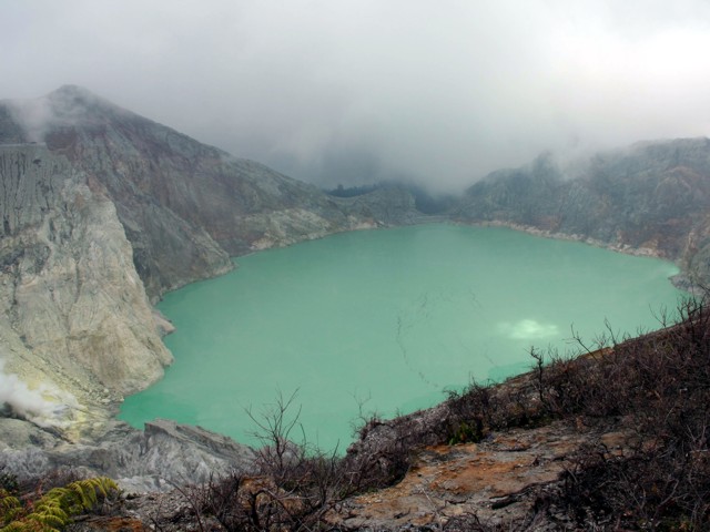 |
Figure 4. Photograph of the acid crater lake and solfatara (bottom left) in the active crater at Ijen, August 2006. View is from the E crater rim. Courtesy of G. Mauri. |
Measurements of temperature and pH were made every morning during 14-19 August at four locations: the Banyupuhit River, ~ 5 km from the Banyupuhit River source, the acid lake in the summit crater, and the E shore of the crater lake. Temperatures of the Banyupuhit River were 16-20°C, always above atmospheric temperature by ~ 1-3°C; the pH was ~ 0.4. Lake temperatures varied between 31 and 43°C and the pH was -0.02. The color of the crater lake was generally homogeneous, although large black to brown linear patches, probably sulfur deposits from the solfatara, were observed on the turquoise-green surface. These ephemeral patches were of variable size (e.g. several ten's of meters long and a few meters wide) and moved across the lake during the course of the day, but were not always evident throughout the day. The area near the E shore appeared lighter than the rest of the lake, probably due to a spring at the bottom of the inner E slope.
Pipes driven into the fumaroles are used to extract gases for sulfur mining (figure 5). Temperatures measured 50 cm down into four of those pipes ranged from 224 to 248°C. These measurements almost certainly represent minimum estimates of the true temperatures due to heat loss along the length of the extraction pipes. After the gases had exited less than 50 cm from the pipes, temperatures had dropped below 120°C, the melting point of native sulfur.
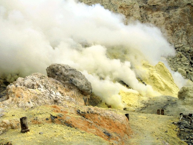 |
Figure 5. Close-up view of the solfatara at Ijen with fumarole temperature of more than 220°C. Note pipes for extracting sulfur gases. Courtesy of G. Mauri. |
A survey of sulfur dioxide (SO2) fluxes made by a portable spectrometer (FLYSPEC) on 21 and 23 August along the SE rim of the crater consisted of seven and twelve walking traverses through the plume, respectively. The gas plume produced directly from the active solfatara near the lake surface rose buoyantly before flowing over the crater rim. During the first survey (conducted over a 2-hour period), the concentration-pathlength of the gas in the plume fluctuated between 1,000 and 2,500 ppm-m. The wind speed (measured by handheld anemometer at plume height) during this time averaged 6.1 m/s and the resultant SO2 flux was therefore calculated to average 412 metric tons per day (t/d) with a standard deviation of 154 t/d. On 23 August, gas concentrations were somewhat lower, ranging between 500 and 2,000 ppm-m. The average wind speed during the survey period (2 hours) was 3.9 m/s and the resultant SO2 flux averaged 254 t/d, with a standard deviation of 117 t/d. Based on this very limited survey, the flux of SO2 was estimated to be 330 t/d.
Gravity surveys (Bouguer and dynamic) were conducted in the active crater and seven gravity stations were selected for future dynamic gravity monitoring. A digital elevation map was prepared (using digital photogrammetric mapping methods) to provide the spatial framework required for interpretation of the geophysical surveys.
The scientists also applied the self-potential (SP) method, also know as spontaneous potential, that measures electrical potentials developed in the Earth by electrochemical action between minerals and solutions with which they are in contact. SP mapping of the active summit crater showed two main hydrologic structures (figure 6). The first is a hydrogeologic zone on the E and NE rim characterized by a negative SP anomaly with a minimum at -100 mV (millivolts), an inverse SP/elevation gradient of -1.6 mV/m, and length of 1,500 m. This almost certainly represents inflow of meteoric water and groundwater.
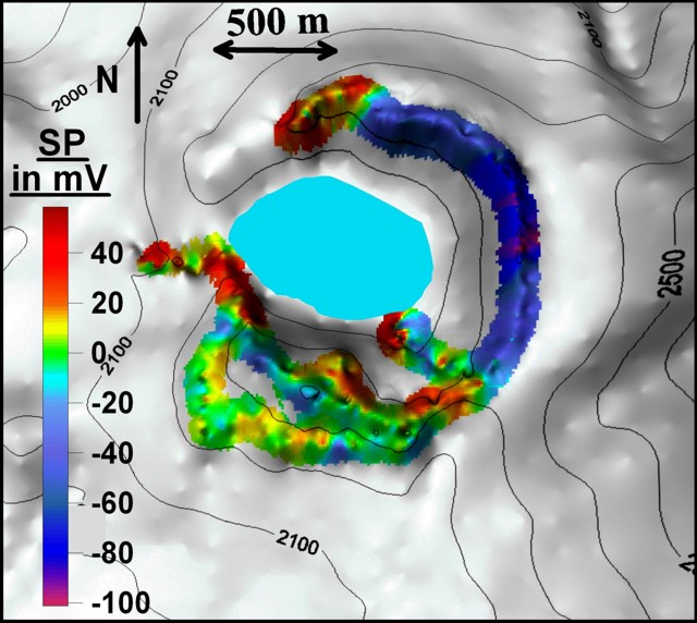 |
Figure 6. Self-potential survey results shown on a topographic map of the active crater of Ijen, August 2006. All the SP data were referenced at the Banyupuhit River and at a spring on the inner E slope of the crater. Contour line intervals are 100 m. Courtesy of G. Williams-Jones. |
The second structure is the main hydrothermal system located S, W, and N of the crater as well as in the southern inner slope of the crater, places where the surface expressions are solfataras. The SP maxima range between 48 and 60 mV and are located on the slope of the river below a dam on the outer W slope (+52 mV), on the N rim (+48 mV) and in the S part of the solfatara (+ 59 mV). Processing of the SP data along the crater profile by continuous wavelet transform (Mauri and others, 2006) shows that the hydrothermal fluid cells are near the surface (less than 200 m below the topographic surface) suggesting that the hydrothermal system is under high pressure with significant heat flux, as shown by the solfatara.
Reference. Mauri, G., Saracco, G., and Labazuy, P., 2006, Volcanic activity of the Piton de la Fournaise volcano characterized by temporal analysis of hydrothermal fluid movement, 1992 to 2005: AGU, Eos Trans, v. 87, no. 52, Fall Meet. Suppl., Abstract V51A-1653.
Geological Summary. The Ijen volcano complex at the eastern end of Java consists of a group of small stratovolcanoes constructed within the 20-km-wide Ijen (Kendeng) caldera. The north caldera wall forms a prominent arcuate ridge, but elsewhere the rim was buried by post-caldera volcanoes, including Gunung Merapi, which forms the high point of the complex. Immediately west of the Gunung Merapi stratovolcano is the historically active Kawah Ijen crater, which contains a nearly 1-km-wide, turquoise-colored, acid lake. Kawah Ijen is the site of a labor-intensive mining operation in which baskets of sulfur are hand-carried from the crater floor. Many other post-caldera cones and craters are located within the caldera or along its rim. The largest concentration of cones forms an E-W zone across the southern side of the caldera. Coffee plantations cover much of the caldera floor; nearby waterfalls and hot springs are tourist destinations.
Information Contacts: Guillaume Mauri and Glyn Williams-Jones, Department of Earth Sciences, Simon Fraser University, Burnaby, BC V5A 1S6, Canada (URL: http://www.sfu.ca/earth-sciences.html); Willy (A.E.) Williams-Jones, Department of Earth and Planetary Sciences, McGill University, Montreal, Quebec, Canada (URL: http://www.mcgill.ca/eps/); Deddy Mulyadi, Center of Volcanology and Geological Hazard Mitigation (CVGHM), Diponegoro 57, Bandung, Jawa Barat 40122, Indonesia (URL: http://vsi.esdm.go.id/).