Report on Kilauea (United States) — May 2007

Bulletin of the Global Volcanism Network, vol. 32, no. 5 (May 2007)
Managing Editor: Edward Venzke.
Kilauea (United States) Lava flows entering the ocean between December 2006 and March 2007
Please cite this report as:
Global Volcanism Program, 2007. Report on Kilauea (United States) (Venzke, E., ed.). Bulletin of the Global Volcanism Network, 32:5. Smithsonian Institution. https://doi.org/10.5479/si.GVP.BGVN200705-332010
Kilauea
United States
19.421°N, 155.287°W; summit elev. 1222 m
All times are local (unless otherwise noted)
Lava from Kīlauea has continued to flow from a lava delta into the ocean at the East Lae`apuki and East Ka`ili`ili entries from early December 2006 through the end of March 2007. Incandescence remained visible on the Pulama pali fault scarp and coastal flats in the vicinity of the Campout flow while incandescence at the East Pond vent, January vent, South Wall complex, and Drainhole and Beehive vents in Pu`u `O`o's crater remained intermittent. On 5 December 2006, a large breakout on Pulama pali resulted in downed and burned trees. On 27 and 28 December, lava streams were seen descending to the ocean to re-establish the Kamokuna entry (figure 183).
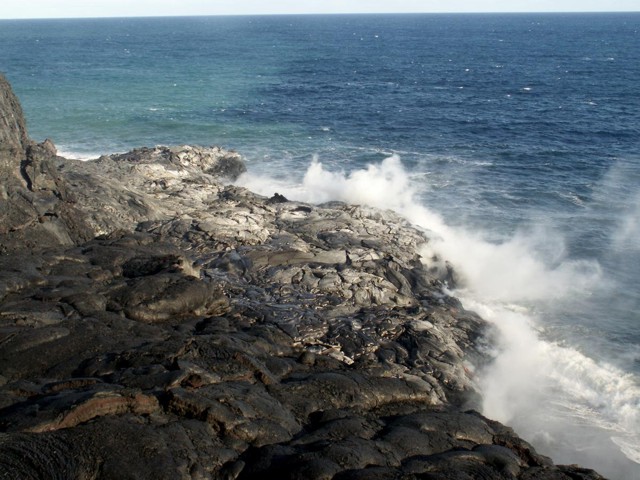 |
Figure 183. View of the Kamokuna ocean entry of the Campout flow from Kīlauea, taken from the sea cliff, 27-28 December 2006. Photo courtesy of Ralf Krug. |
During January and February, lava continued to flow from a lava delta into the ocean at East Lae'apuki, Kamokuna (figure 184), and East Ka'ili'ili entries with incandescence intermittently visible on the pali from the East Pond and January vents, South Wall complex, and Drainhole vent in Pu`u `O`o crater. On 12 January, the summit tilt network recorded the start of the tenth deflation-inflation (DI) event; after 7 microradians of deflation the largest of the earlier events was approximately 2 microradians. Inflation began on 13 January with increased and decreased tremor near Pu`u `O`o in response to the DI event. On 24 January, breakout lava from the Campout flow advanced approximately 1.6 km per hour. A USGS field crew reported several smaller breakouts of lava from the flow at the base of the pali that flowed E and burned trees near the long-abandoned Royal Gardens subdivision.
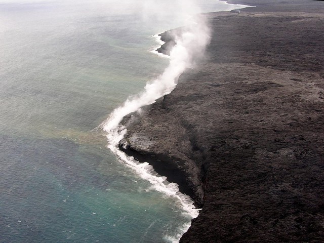 |
Figure 184. Visible steam plumes from the Kamokuna ocean entry at Kīlauea, 22 February 2007. Courtesy of HVO. |
Breakout surface lava from the Campout flow produced seven lava falls over the seacliff behind the East Lae'apuki bench on 15 February and continued throughout the week. On 22 February, HVO field crews reported gas jetting from vents on the S side of Pu`u `O`o.
On 10 March, lava stopped flowing at the East Ka`ili`ili ocean entry, possibly due to branching off W towards the Royal Gardens subdivision. `A`a flows from the Campout flow were seen on the pali on 14 and 27 March. During 28-29 March, there was an unusual increase in the number of earthquakes located near the Halema'uma'u and Koko'olau craters and on the S flank. Then on 31 March, a major lava breakout from the Campout flow caused trees to ignite on a nearby island of vegetation and produced small explosion from trapped gas.
Geological Summary. Kilauea overlaps the E flank of the massive Mauna Loa shield volcano in the island of Hawaii. Eruptions are prominent in Polynesian legends; written documentation since 1820 records frequent summit and flank lava flow eruptions interspersed with periods of long-term lava lake activity at Halemaumau crater in the summit caldera until 1924. The 3 x 5 km caldera was formed in several stages about 1,500 years ago and during the 18th century; eruptions have also originated from the lengthy East and Southwest rift zones, which extend to the ocean in both directions. About 90% of the surface of the basaltic shield volcano is formed of lava flows less than about 1,100 years old; 70% of the surface is younger than 600 years. The long-term eruption from the East rift zone between 1983 and 2018 produced lava flows covering more than 100 km2, destroyed hundreds of houses, and added new coastline.
Information Contacts: Hawaiian Volcano Observatory (HVO), U.S. Geological Survey, PO Box 51, Hawai'i National Park, HI 96718, USA (URL: https://volcanoes.usgs.gov/observatories/hvo/).