Report on Okmok (United States) — July 2008
Bulletin of the Global Volcanism Network, vol. 33, no. 7 (July 2008)
Managing Editor: Richard Wunderman.
Okmok (United States) Mid-July to mid-August 2008: abundant tremor and ash plumes to ~11 km altitude
Please cite this report as:
Global Volcanism Program, 2008. Report on Okmok (United States) (Wunderman, R., ed.). Bulletin of the Global Volcanism Network, 33:7. Smithsonian Institution. https://doi.org/10.5479/si.GVP.BGVN200807-311290
Okmok
United States
53.43°N, 168.13°W; summit elev. 1073 m
All times are local (unless otherwise noted)
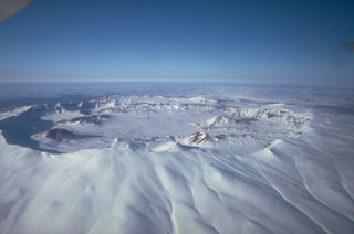
This report discusses the important explosive eruption of Okmok (figure 3) that began on 12 July 2008 (BGVN 33:06) and summarizes the period from mid-July to mid-August 2008. Vigorous eruptions continued with many plumes over 4 km altitude and some as tall as ~ 11 km. The information in this report is mostly compiled from daily and weekly AVO postings. Remote sensing data showed vigorous eruption plumes that spread over North America; these plumes were unusually complex and well-documented in photographs by pilots, including some over Montana (USA), thousands of kilometers from the volcano. Other powerful eruptions in the region included those at Cleveland and an SO2-rich eruption from Kasatoshi. Near Okmok, cloud cover often restricted views.
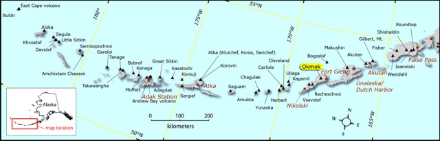 |
Figure 3. Map showing Okmok and vicinity. Courtesy of Janet Schaefer, Alaska Volcano Observatory / Alaska Division of Geological & Geophysical Surveys (AVO/ADGGS). |
On 19 July seismicity increased markedly and reached a level commonly associated with vigorous ash emissions. The seismic data was consistent with explosive ash plumes and an image (AAVHRR thermal IR (Channel 4)) indicated cloud temperatures of -50°C, suggesting an altitude of at least 9.1 km.
Satellite imagery from 20 July revealed an ash plume ~ 20 km from Okmok drifting SE at 3.7 km altitude. Nearly continuous volcanic tremor changed to tremor of a more episodic character, and the overall seismic intensity declined. Additional ash plumes observed on satellite imagery and spotted by pilots rose to altitudes of 4.6-6.1 km. On this day a photograph taken from an Alaska Airlines jet captured an impressive plume from Okmok from 11.3 km (37,000 ft) altitude (figure 4).
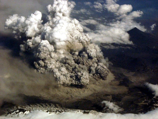 |
Figure 4. A 20 July aerial photo of the Okmok eruption made looking S from a spot ~ 24 km away (taken at approximately 1950 ADT). Estimated tops of ash and vapor were at 6.2 km (20,000 ft.) altitude. Photo taken by Phil Walgren. |
Aerial photographs and video footage was collected by AVO staff and others on 20 and 21 July. It confirmed the presence of multiple vigorous vents on the caldera floor.
The flights on 21 July revealed Okmok ash on the snow at Makushin volcano. During 21-22 July, ash plumes continued to be present and rose to altitudes of 6.1-9.1 km and drifted SE. Okmok's seismicity remained episodic, but well above background. On 23 July, tremor that was episodic in duration shifted to nearly continuous and grew to mid-level amplitudes. Although cloud cover obscured views of Okmok that day, previously emitted ash plumes were visible to the ESE. On 24 July, a thermal anomaly was possibly present on satellite imagery. Lahar damage to bridges and roads in Fort Glenn was evident. Around this time, the sailing vessel "Minnow" endured ashfall during a 30-minute interval. The thickness of ash deposited was not disclosed, but ash removal required five hours of cleaning.
Seismic amplitude increased on 25 July. Based on pilot reports and observations of satellite imagery, AVO reported that ash plumes rose to altitudes of 10.7-12.2 km.
On 26 July, seismicity decreased and satellite imagery indicated that ash plumes rose to altitudes of 6.1-6.7 km. Seismicity increased again on 27 July. Satellite imagery possibly indicated another thermal anomaly; a possible plume at an altitude of less than 3 km was also noted.
Two photos (figures 5 and 6) illustrate the new delta resulting from fresh ash deposits eroded and carried to the mouth of Crater Creek. The first photo was taken 27 July, the second, 2 August.
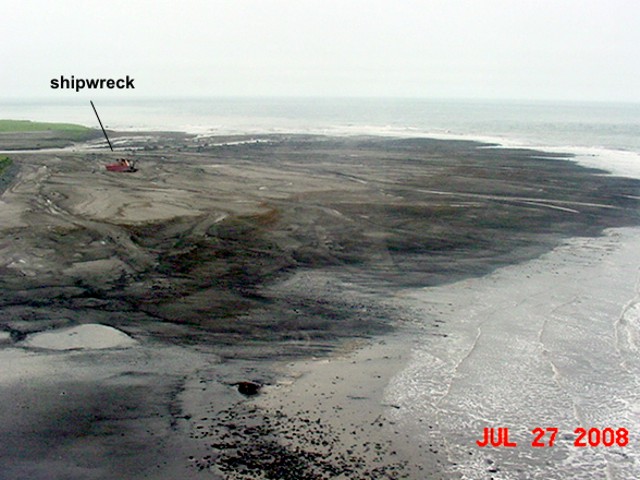 |
Figure 5. A 27 July 2008 photo illustrating the broad delta formed by lahars along Okmok's Crater Creek. The "Equinox," the shipwreck on the left side of the photo, used to be awash before the July 2008 eruption. Photo courtesy of Lonnie Kennedy. |
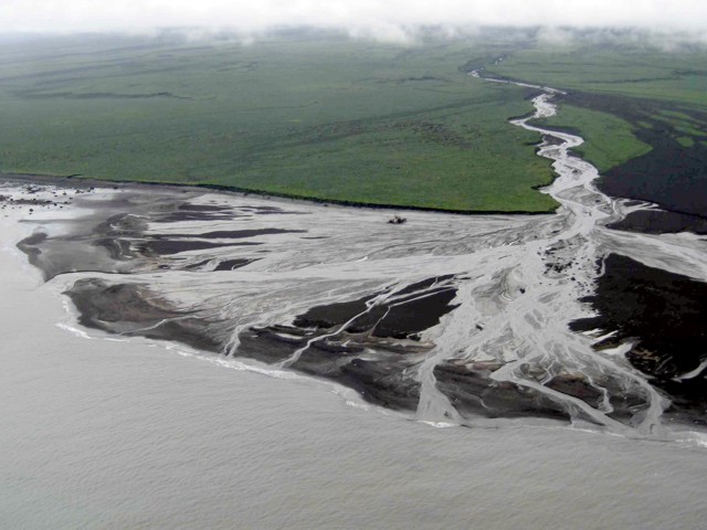 |
Figure 6. Another view of the new Okmok lahar delta formed at Cape Tanak, where Crater Creek enters the sea. The shipwreck lies in the center of this photo. Photo taken 2 August 2008 by Jessica Larsen, Alaska Volcano Observatory / University of Alaska Fairbanks, Geophysical Institute (AVO/UAF-GI). |
On 28 July, tremor decreased. Ash plumes at altitudes of 8.2-10.7 km drifted E and SE. Tremor shifted from nearly continuous to episodic. Later that day and on 29 July, discrete plumes containing some ash rose to altitudes of 6.1-10.7 km and drifted E to SE.
According to pilot reports and analysis of satellite imagery for 30 July, ash plumes then rose to altitudes of 4.6-6.1 km and drifted W. Seismicity alternated between periods of continuous and pulsating tremor. On 31 July, ash plume at altitudes of 9.1-9.8 km were seen on satellite images. On 31 July, reports from a fishing boat 11.3 km N indicated visibility had ceased due to ashfall. The National Weather Service issued an ashfall advisory for Umnak Island and Unalaska/Dutch Harbor that remained in effect until 2400 on 1 August.
Strong volcanic tremor on 2 August prompted AVO to raise the Volcano Alert Level and the Aviation Color Code to the highest level. Cloudy conditions prevented satellite observations. Later that day, AVO geologists in the area reported that ash-and-steam plumes rose to minimum altitude of 6.1 km. The seismicity then decreased. Next, observers in Fort Glenn on Umnak Island reported smelling sulfur and seeing a larger ash plume than earlier that day. The plume drifted ESE.
AVO scientists observed the eruption during a visit on 2 and 3 August. They saw significant ashfall accumulated in the caldera and on the upper flanks. Lahars and lahar deltas had formed in drainages from the SE to the NE flank (figure 7). Continuous ash jets escaped from three or more vents in the NE sector of the caldera.
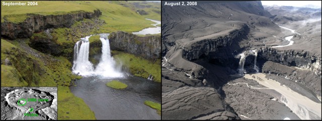 |
Figure 7. Before-and-after photographs of the falls on Crater Creek, the outflow stream draining Okmok caldera on its NE side. The right photo was taken on 2 August, three weeks after the onset of the 2008 eruption. The left photo is approximately the same view taken in September 2004. Okmok is treeless, but at lower elevations is covered with a verdant blanket of wildflowers and grasses. The index image (lower-left corner) is from a digital elevation map (DEM). Both photographs and the DEM are by Janet Schaefer, AVO/ADGGS. |
Figure 8 shows a view of a 3 August eruption, as seen from a commercial airliner. The plume was also seen midday on 3 August (figure 9). On that day, both helicopter and ground-based observers indicated an ash plume at lower altitude along with a steam plume at higher altitude. Satellite imagery revealed ash plumes at altitudes of 9.1-10.7 km drifting SSW.
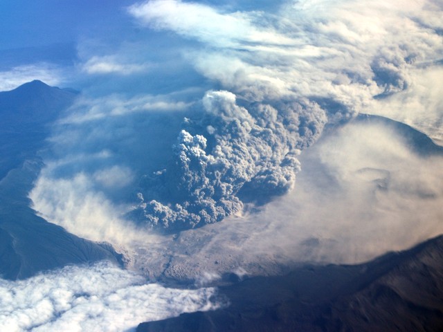 |
Figure 8. View of Okmok eruption, taken from a NE-bound Alaska Airlines flight at ~ 10.7 km (35,000 ft) altitude on 3 August 2008 (between the hours of 2000 and 2008). Plume tops estimated to ~ 2.1 km (~ 7,000 ft) altitude using nearby Mount Vsevidof (summit elevation, 2,149 m 7,051 ft) for reference. Courtesy of Burke Mees. |
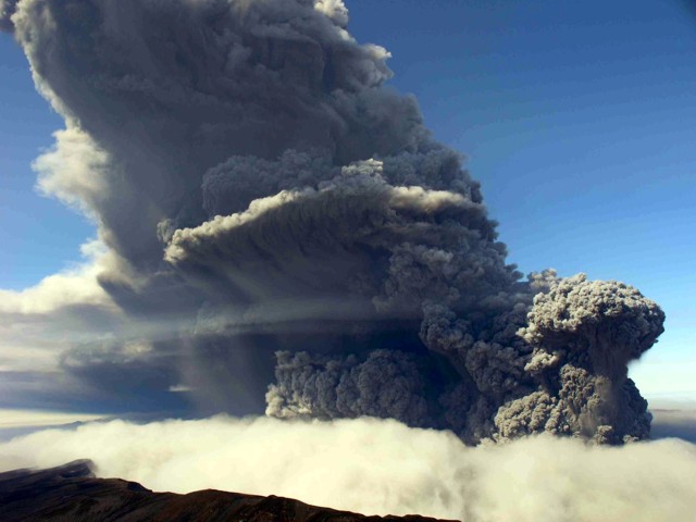 |
Figure 9. View of Okmok's ash plume emitting from multiple vents near intracaldera Cone D. Photo taken on 3 August 2008 by Jessica Larsen, Alaska Volcano Observatory / University of Alaska Fairbanks, Geophysical Institute (AVO/UAF-GI). |
On 4 August, ashfall reported in the settlement of Nikolski (80 km SW) had accumulated to a depth of 3 mm. During 4-5 August, satellite imagery and pilot observations indicated that ash plumes rose to altitudes of 3-7.6 km and drifted SW and W.
Elevated seismicity occurred during 6-8 August, and declined on 9 August. According to satellite imagery for 9-10 August, there were steam plumes possibly containing ash rising up to 4.6 km altitude. On 11 August, steam plumes rose to less than 6.1 km altitude and drifted SE. Ash plumes that rose to around a hundred meters above the crater were reported by an observer in Nikolski. These plumes were not detected on satellite imagery due to cloud cover. On 12 August, a pilot reported an ash plume at an altitude of 4.6 km.
AVO reported that a new vent was active on 13 August. Emissions that day, possibly from multiple vents, were rich in both ash and steam. Low-level steam-and-ash plumes were visible on satellite imagery drifting SE at altitudes of 3-4.6 km. During 14-17 August satellite observations were hindered due to cloud cover; seismic levels fluctuated, possibly indicating that steam-and-ash emissions continued. During 18-19 August, ash plumes were seen on satellite imagery at altitudes of 3-4.6 km.
No thermal anomalies related to Okmok were measured by MODIS satellites during January-August 2008.
Geological Summary. The broad, basaltic Okmok shield volcano, which forms the NE end of Umnak Island, has a dramatically different profile than most other Aleutian volcanoes. The summit of the low, 35-km-wide volcano is cut by two overlapping 10-km-wide calderas formed during eruptions about 12,000 and 2050 years ago that produced dacitic pyroclastic flows that reached the coast. More than 60 tephra layers from Okmok have been found overlying the 12,000-year-old caldera-forming tephra layer. Numerous satellitic cones and lava domes dot the flanks of the volcano down to the coast, including 1253-m Mount Tulik on the SE flank, which is almost 200 m higher than the caldera rim. Some of the post-caldera cones show evidence of wave-cut lake terraces; the more recent cones, some of which have been active historically, were formed after the caldera lake, once 150 m deep, disappeared. Hot springs and fumaroles are found within the caldera. Historical eruptions have occurred since 1805 from cinder cones within the caldera.
Information Contacts: Alaska Volcano Observatory (AVO), a cooperative program of the U.S. Geological Survey, 4200 University Drive, Anchorage, AK 99508-4667, USA (URL: http://www.avo.alaska.edu/), the Geophysical Institute, University of Alaska, PO Box 757320, Fairbanks, AK 99775-7320, USA, and the Alaska Division of Geological and Geophysical Surveys, 794 University Ave., Suite 200, Fairbanks, AK 99709, USA.