Report on Asamayama (Japan) — December 2008
Bulletin of the Global Volcanism Network, vol. 33, no. 12 (December 2008)
Managing Editor: Richard Wunderman.
Asamayama (Japan) Late January 2009 eruption; another on 2 February with significant ashfall
Please cite this report as:
Global Volcanism Program, 2008. Report on Asamayama (Japan) (Wunderman, R., ed.). Bulletin of the Global Volcanism Network, 33:12. Smithsonian Institution. https://doi.org/10.5479/si.GVP.BGVN200812-283110
Asamayama
Japan
36.406°N, 138.523°E; summit elev. 2568 m
All times are local (unless otherwise noted)
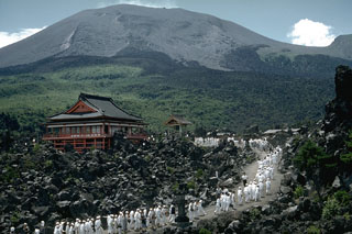
Asama (figure 31) erupted in January and February 2009. Following three small eruptions in August 2008 (BGVN 33:08), glow was frequently reflected by steam over the summit crater. High seismicity began suddenly on 1 January 2009 and prevailed through that month (figure 32). By 21 January 2009 scientists from the Japan Meteorological Agency (JMA) had discovered a thin ash layer covering the NW rim of Asama's summit crater (figure 33).
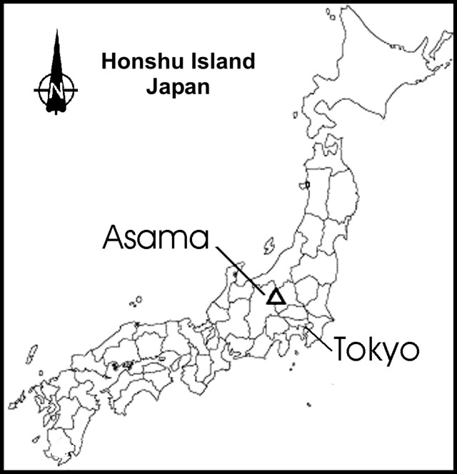 |
Figure 31. A sketch map centered on Honshu Island (Japan) indicating the location of Asama. The volcano sits 140 km NW of Tokyo. Courtesy of Japan Meteorological Agency (JMA). |
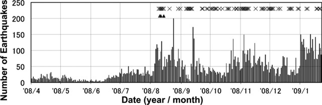 |
Figure 32. Plot of daily earthquakes registered at Asama during April 2008 through January 2009. At the top of the plot, the triangles indicate times of both earthquake and recognized eruption during the August 2008 eruptive episode; the Xs indicate times of visible glow (common during August 2008 and often visible thereafter). Courtesy of JMA. |
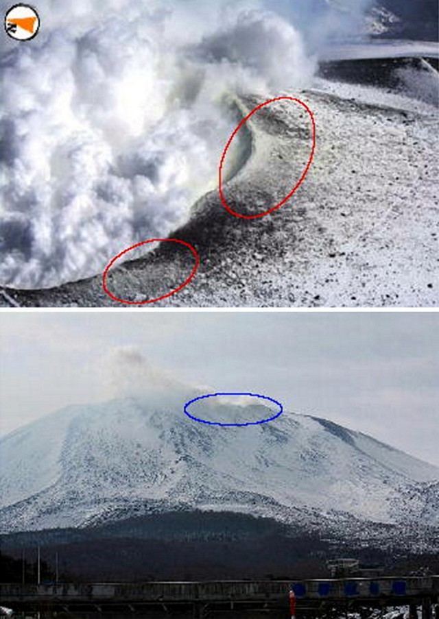 |
Figure 33. Two photos of Asama's steaming summit taken on 16 January (top, looking down on the crater's NW rim) and 21 January 2009 (bottom, viewed from the S). Dark material on 16 January was interpreted as older, perhaps in part from the 2004 eruption; circled areas indicate zones continaing yellow (sulfurous) sublimate. Circled areas on the 21 January photo indicate zones where thin ashfall was noted. Courtesy of JMA. |
The highest SO2 flux in recent years, over 5,000 metric tons/day, was recorded on 15 January 2009 (figure 34). JMA also noted minor crustal deformation.
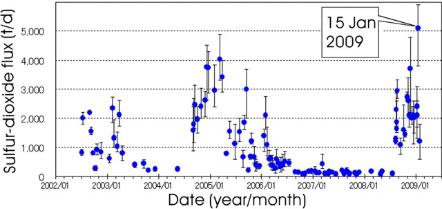 |
Figure 34. A plot of SO2 flux emitted from Asama between January 2002 and January 2009. Error bars indicate the high and low values of 5-7 measurements. Courtesy of JMA. |
Yukio Hayakawa visited Maebashi (a town ~50 km E of the summit) during January 2009. Local people told him that they felt the intensity of Asama's recent plumes had been high, more vigorous than in 2004 (BGVN 29:08).
An Associated Press story issued 2 February 2009 contained a video of Asama's ash- and bomb-peppered summit, with the crater emitting billowing white plumes. At night enormous red areas above the summit suggested the sudden ejection of molten material. That news report stated that JMA had seen an eruption in the early hours of 2 February. They said that some ash fell on parts of Tokyo. Later reports will present more details on that and later eruptions.
Geological Summary. Asamayama, Honshu's most active volcano, overlooks the resort town of Karuizawa, 140 km NW of Tokyo. The volcano is located at the junction of the Izu-Marianas and NE Japan volcanic arcs. The modern Maekake cone forms the summit and is situated east of the remnant of an older andesitic volcano, Kurofuyama, which was destroyed by a late-Pleistocene landslide about 20,000 years before present (BP). Growth of a dacitic shield volcano was accompanied by pumiceous pyroclastic flows, the largest of which occurred about 14,000-11,000 BP, and by growth of the Ko-Asamayama lava dome on the east flank. Maekake, capped by the Kamayama pyroclastic cone that forms the present summit, is probably only a few thousand years old and has observed activity dating back at least to the 11th century CE. Maekake has had several major Plinian eruptions, the last two of which occurred in 1108 (Asamayama's largest Holocene eruption) and 1783 CE.
Information Contacts: Japan Meteorological Agency (JMA), Otemachi, 1-3-4, Chiyoda-ku, Tokyo 100-8122, Japan (URL: http://www.jma.go.jp/); Volcano Research Center, Earthquake Research Institute (ERI), University of Tokyo, Yayoi 1-1-1, Bunkyo-ku, Tokyo 113, Japan (URL: http://www.eri.u-tokyo.ac.jp/topics/ASAMA2004/index-e.html); Yukio Hayakawa, Gunma University, Faculty of Education, Aramaki 4-2, Maebashi 371-8510, Japan; Associated Press (URL: http://www.ap.org/).