Report on Dugong (Tonga) — June 2013

Bulletin of the Global Volcanism Network, vol. 38, no. 6 (June 2013)
Managing Editor: Richard Wunderman.
Dugong (Tonga) New active submarine volcano found in North Lau Basin, E of Fiji
Please cite this report as:
Global Volcanism Program, 2013. Report on Dugong (Tonga) (Wunderman, R., ed.). Bulletin of the Global Volcanism Network, 38:6. Smithsonian Institution. https://doi.org/10.5479/si.GVP.BGVN201306-243111
Dugong
Tonga
15.431°S, 175.725°W; summit elev. -1170 m
All times are local (unless otherwise noted)
According to the Australian Commonwealth Scientific and Industrial Research Organization (CSIRO), several large active submarine volcanoes, spreading ridges, and rift zones have been discovered in the Northwest Lau back-arc basin, NE of Fiji Island (figure 1), by a team of Australian and American scientists aboard the CSIRO Marine National Facility Research Vessel Southern Surveyor during a research cruise in Spring 2008 (CSIRO, 2008b). While mapping previously uncharted areas for submarine volcanic and hot spring activity with multibeam sonar and various other techniques, the team located several active volcanoes, one of which they named Dugong. The depth of Dugong is given in the InterRidge Vents Database [Ver. 3.1] (2013), and its location was plotted on figure 1 based on coordinates given in Lupton and others (2012).
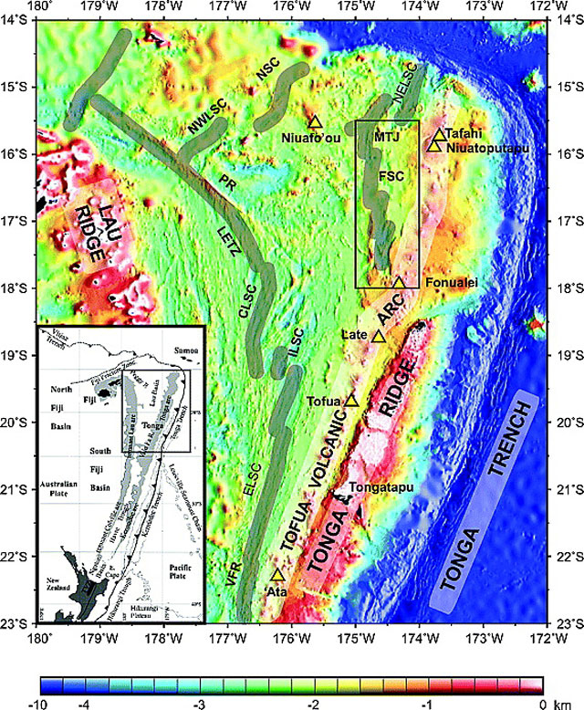 |
Figure 1. Two maps showing (lower left) North Island, New Zealand (in black) and selected plate tectonic features along the Kermadec and Tonga trenches (hachured line with teeth on upthrown side) and (larger map) Dugong (white square) and other features such as the main spreading centers, geographical features, and subaerial volcanoes (open yellow triangles). Note Niuafo'ou volcano and island. The base maps in figure 1 came from Keller and others (2008), a study primarily discussing the area in the rectangle on the larger map. The sea floor was mapped with multibeam sonar (soundings normal to the ship's track). Abbreviations are as follows: VFR - Valu fa ridge; ELSC - East Lau spreading center; ILSC - Intermediate Lau spreading center; CLSC - Central Lau spreading center; LETZ - Lau Extensional transform zone; PR - Peggy Ridge; NWLSC - Northwest Lau spreading center; NSC - Niuafo'ou spreading center (location of Rochambeau Rifts); NELSC - Northeast Lau spreading center; FSC - Fonualei spreading center; and MTJ - Mangatolu triple junction. Courtesy of Keller and others (2008). |
As shown in figure 2, the greater Dugong structure is dominated by a 5-km-diameter caldera at a depth of 1,100 m. Dugong volcano is located ~60 km E of Lobster volcano, ~20 km WNW of Niuafo'ou volcano/island, and ~680 km NE of Suva, Fiji.
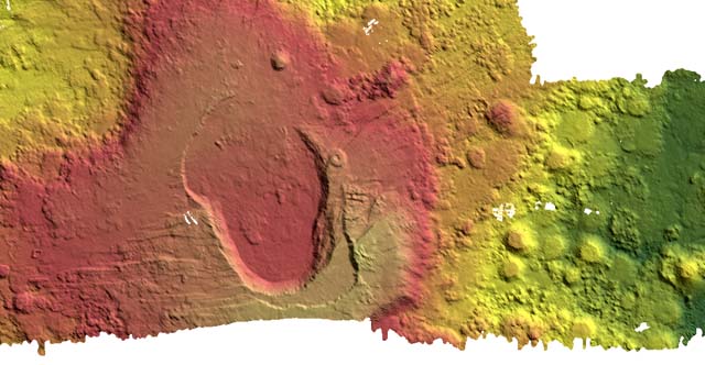 |
Figure 2. Multibeam sonar three-dimensional (30 kHz swathmap) image of submarine volcano Dugong. A Global Positioning System (GPS) and an Inertial Motion Unit (IMU) were used to monitor the ship's position and attitude. The large volcano, 45 km in diameter, is located 25 km NW of the subaerial back-arc island volcano of Niuafo'ou. A 5 km diameter crater forms the summit region of the volcano, with a small hydrothermal plume near its base. The mapping revealed an enormous structure with hundreds of individual eruptive blobs and transected by numerous faults. A dredge of the SW floor of the caldera recovered a few fresh basaltic pillow fragments, volcanic glass, and small pieces of pumice. There is no color scale for the image for conversion to depth, although dark green is the deepest, trending upwards through yellow, orange, red, and tan. Location and distance scales are also missing from the figure. Image from CSIRO (2008b); with ancillary information from Arculus (2008). |
During the 6 week research expedition in the Pacific Ocean, scientists from the Australian National University (ANU), CSIRO Exploration & Mining, and the United States collaborated to survey the topography of the seafloor, analyzing rock types and formations, and monitoring deep sea hot spring activity around an area known as the North Lau Basin, 400 km NE of Fiji.
References. Arculus, R.J., 2008, Marine National Facility RV Southern Survey 2008 Program: Voyage Summary SS07/2008 Northern Lau Vents Expedition (NoLauVE), 23 p (URL: http://www.cmar.csiro.au/datacentre/process/data_files/cruise_docs/SS200807sum.pdf).
CSIRO, 2008a, Active submarine volcanoes found near Fiji, CSIRO web site (URL: http://www.csiro.au/Organisation-Structure/Divisions/Earth-Science--Resource-Engineering/SubmarineVolcanoes.aspx).
CSIRO, 2008b, Active submarine volcanoes found near Fiji, CSIRO media release (URL: http://www.scienceimage.csiro.au/mediarelease/mr08-93.html).
de Ronde, C.E.J, Baker, ET, Massoth, G.J, Lupton, J.E, Wright, I.C., Feely, R.A., and Greene, R.R., 2001, Intra-oceanic subduction-related hydrothermal venting, Kermadec volcanic arc, New Zealand, Earth and Planetary Science Letters, v. 193, p. 359-369.
Graham, I.J., Reyes, A.G., Wright, I.C., Peckett, K.M., Smith, I.E.M., and Arculus, R.J., 2008, Structure and petrology of newly discovered volcanic centers in the northern Kermadec-southern Tofua arc, South Pacific Ocean, Journal of Geophysical Research, v. 113, B08S02, doi:10.1029/2007JB005453.
InterRidge Vents Database Ver. 3.1, 2013, Vent Fields (URL: http://www.interridge.org/irvents/ventsfields?).
Keller, N.S., Arculus, R.J., Hermann, J., and Simon, R., 2008, Submarine back arc lava with arc signature: Fonualei Spreading Center, northeast Lau Basin, Tonga, Journal of Geophysical Research, v. 113, B08S07, doi:10.1029/2007JB005451.
Lupton, J.E., Arculus, R.J., Resing, J., Massoth, G.J., Greene, R.R., Evans, L.J., and Buck, N., 2012, Hydrothermal activity in the Northwest Lau Backarc Basin: Evidence from water column measurements, Geochemistry, Geophysics, Geosystems, v. 13, no. 5, doi: 10.1029/2011GC003891. Information Contacts. Commonwealth Scientific and Industrial Research Organization (CSIRO) (URL: http://www.csiro.au).
Geological Summary. This volcano was discovered during an Australian research cruise in 2008. The overall edifice is 45 km in diameter, with a 5-km-diameter summit caldera.
Information Contacts: Commonwealth Scientific and Industrial Research Organization (CSIRO) (URL: http://www.csiro.au); National Oceanic and Atmospheric Agency (NOAA) (URL: http://www.CSC.noaa.gov/crs/rs_apps/sensors/multi_beam.htm); Richard Arculus, Australian National University Research School of Earth Sciences; and Frederick Stein, Director, Marine National Facility, CSIRO.