Report on Rabaul (Papua New Guinea) — August 2014

Bulletin of the Global Volcanism Network, vol. 39, no. 8 (August 2014)
Managing Editor: GVP Staff.
Rabaul (Papua New Guinea) Minor eruptions continue until 29 August 2014, explosion sends ash plume to 18 km altitude
Please cite this report as:
Global Volcanism Program, 2014. Report on Rabaul (Papua New Guinea) (GVP Staff, ed.). Bulletin of the Global Volcanism Network, 39:8. Smithsonian Institution. https://doi.org/10.5479/si.GVP.BGVN201408-252140
Rabaul
Papua New Guinea
4.2459°S, 152.1937°E; summit elev. 688 m
All times are local (unless otherwise noted)
Our last Bulletin report (BGVN 38:10) covered from August 2011 to December 2013, during which Rabaul's intracaldera cone, Tavurvur, often discharged modest eruptions. During that period there were several distinct events ranging from significant ashfall to the creation of a new lava dome in June 2013. This report describes activity at the Tavurvur cone between January 2014 and the end of September 2014, using data primarily gathered from the Rabaul Volcanic Observatory (RVO) and the Darwin Volcanic Ash Advisory Center (VAAC). Excepting the event on 29 August 2014 when Tavurvur sent an ash plume to ~18 km altitude, activity consisted mostly of a few minor explosions and ashfall. Caldera unrest, which included earthquakes and deformation, also continued. Ashfall is a continuing hazard in Rabaul town (3-5 km NW), which according to a recent survey has a population of ~10,000 people; an estimated 52,693 people live within a 10-km radius of Tavurvur.
Activity during January-August 2014. Tavurvur remained mostly quiet in January-February 2014 with varying amounts of white to blue vapor rising up to 100 m over the crater rim. Seismicity was low with a few small earthquakes. On 12 February a diffuse gray/brown ash plume rose 50-100 m. Only the summit was affected by the resulting ashfall. GPS measurements showed a constant yet slow uplift of the middle of the caldera.
Tavurvur continued to have small to moderate explosions in March, with gray ash plumes rising 1000 m. Deposits were characterized by a thin layer of brown ash. Explosion earthquakes were recorded on 1 (1), 6 (2), 7 (1), 8 (1), 9 (1), 10 (1), and 11 (2) March. Ash emissions continued and led to browned flora on the nearby peak, Turanguna (aka. South Daughter). During the latter part of March, Tavurvur quieted, and was either without vapor or only released white vapor. Seismicity during this period was very low, but a few low-frequency earthquakes occurred during explosions. There were three M~5 earthquakes on 20 March and a few very small earthquakes between 28 and 30 March (unstated quantity and magnitude). Short-term inflation was seen on Matupit Island, and continuous long-term inflation on the Tavurvur cone. In past years, Rabaul's caldera floor has undergone long-term recovery from the 1994 eruption and on Matupit Island there has been deflation associated with the 2006 eruption, during which a benchmark subsided by ~55 cm. RVO noted that the most likely cause of the recent Matupit inflation was processes (e.g. intrusion/vesiculation) affecting the volume of the magma at depth.
During April-June 2014 there were no VAAC reports or RVO data available. SO2 data from NASA showed only very modest plumes, suggesting little activity. There was hardly any activity in July and most of August except for an ash emission that drifted NNW and resulted in ashfall in Rabaul town on 7 July. Distinct ashfall events occurred on 15, 16, 17, and 26 July. RVO noted minor plumes (up to 1 km altitude) of white vapor and a little blue vapor which they attributed to new hot material near the surface. Seismicity was low with three earthquakes (intensity III–IV) on 15 July and a single low-frequency event on each of 15, 16, 21, 22, and 29 July, with five such events on 26 July. Larger magnitude earthquakes on 15-17 and 26 July corresponded to volcanic explosions. An examination of the summit crater on 25 July showed a weak glow on the summit and that the crater had deflated since the earlier 10 July examination. There were also regular low noises produced by gas release. No additional RVO data was issued until 29 August.
Explosion on 29 August 2014. The most dramatic event during the past several years occurred when a Strombolian explosion starting between 0330 and 0400 and lasting until 0657 on 29 August sent an ash plume to ~18 km altitude (figure 61). Smaller explosions at irregular intervals continued through 0641 on 30 August (figure 62). Table 14 provides an overview of key events during the eruption. A crater inspection during late September indicated that the 29 August eruption left the crater shallower. The visible fill consisted of blocky lava and the once smooth rim was covered with large chunks. Observers also noted active emissions at 3-4 areas.
Table 14. Details of Rabaul's explosion and seismic activity on 29 August 2014. Noises such as explosive, roaring, or rumbling sounds were largely omitted. The primary data source is RVO, but most of the information shown was conveyed through Darwin VAAC reports. All times are local unless otherwise noted, UTC + 10 hours.
| Date (Time) | Remarks |
| 29 Aug (0330-0400) | Start of Strombolian eruption. Shock waves. |
| 29 Aug (0400-0530) | Eruption plume ~3000 m above Tavurvur's vent moving WNW. Ash and scoria affected Rabaul town before the wind shifted, to later affect Malaguna, Matupit, and S of the vent. |
| 29 Aug (0645-0657) | Eruption's subsidence/conclusion. Diffuse white emissions. |
| 29 Aug (daylight) | Strong explosions. Lessened seismic activities. Conclusion of volcanic tremors. 1000 m altitude ash plumes drifted NW. 0848: First Volcanic Ash Advisory (VAA) issued. Satellite image acquired 44 min. later (MTSAT-2). |
| 30 Aug (night) | Strong discrete explosions. Thick, white 1000 m ash plumes drifted NW. Increased time interval in between events accompanied by incandescent lava fragments (figure 4). 1254-1435: Data was acquired for the OMI satellite image with the largest SO2 plume (Fig. 8) |
| 30 Aug (0641) | End of strong explosions. White vapor and minor diffuse blue vapor. |
| 30-31 Aug | High seismicity with several low-frequency earthquakes, 80/hour. |
| 31 Aug (0300) | Decreased seismicity. Low-frequency earthquakes, 15/hour. |
| 01-12 Sep | Subsidence of all activity. White vapor and minor blue vapor. Fine ash on the ground swept into atmosphere by SE winds. No night glow. Discrete explosions and mild ash puffs on 1-2 Sep. Minimal ground deformation. Low seismicity with low-frequency earthquakes occurring at a rate of 10/hour during 1-2 Sep; 15-20/hour during 3-4 Sep; 20-30/hour during 5-12 Sep. |
| 13-19 Sep | Mild activity. Low seismicity with 25-35 total low-frequency earthquakes. Ground deformation fluctuating within 2 cm of the new elevation reached during the 29 August eruption. On 18 Sep, an explosion at 1242 produced a pale gray ash plume reaching ~500 m above the vent before moving NW. |
| 20-26 Sep | Mild activity, tectonic earthquake, and crater inspection. Diffuse white vapor and minute traces of blue vapor. Low seismicity with 15-20 total low-frequency earthquakes. |
| 27 Sep-03 Oct | Mild activity, tectonic earthquake. Diffuse white vapor and minute traces of blue vapor. Low seismicity with less than 10 total low-frequency earthquakes. |
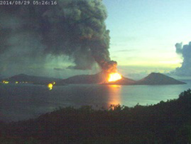 |
Figure 61. Rabaul's 29 August 2014 eruption glowing intensely and emitting a plume at 0526. This was captured about two hours after the eruption's onset, facing approximately NNE. Rabaul town is to the left and the harbor entrance of Blanche bay is towards the right. Courtesy of PNG Climate Network. |
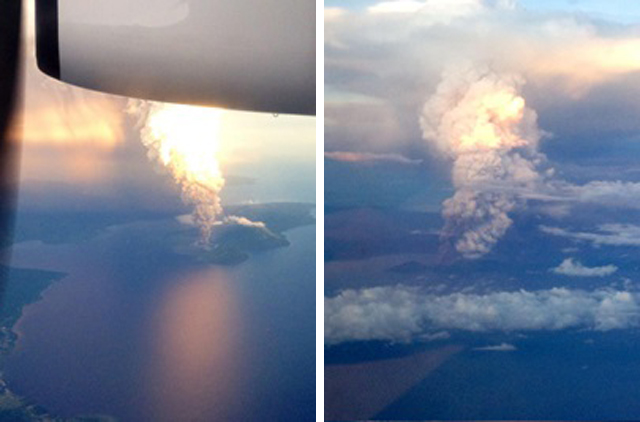 |
Figure 62. Two views of the ash plume on 30 August 2014 from Rabaul's Tavurvur as seen from an airplane. In the topmost picture, Tavurvur's vent and Blanche bay are easily distinguishable. Courtesy of Derek Schock (as posted on Twitter). |
Satellite imagery (MTSAT-2 VDIFF) taken ~6 hours after the eruption's onset showed that the plume had slightly detached from the vent and been swept into a funnel-like shape fanning W to SW of the vent. According to VAAC reports from the same time, the ash plume had an altitude of ~18 km. Darwin VAAC noted that the direction and speed of all three plumes on 29 August were assessed using ash and SO2 data. A few hours after the eruption, the ash diffused, leaving behind SO2 in the atmosphere.
Ashfall in New Britain was mainly to the W of Tavurvur (figure 63). On 31 August no new airborne ash was detected and all volcanic ash advisories were terminated. By the end of September, the remains of atmospheric ash and SO2 released by the 29 August eruption had completely disappeared.
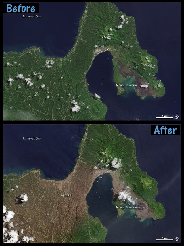 |
Figure 63. Landsat images of New Britain from 27 April 2014 and 2 September 2014, depicting the ashfall from the 29 August 2014 eruption. As seen in the lower image, the ash (brown area) deposited towards the W and at a distance curved SW. Courtesy of Jesse Allen and Adam Voiland, NASA Earth Observatory. |
Satellite SO2 emissions and mass estimates. Tavurvur's SO2 emissions varied throughout the reporting period with only small masses recorded in the atmospheric column except for those related to the late August eruption. The purpose of these SO2 mass values is to establish the size and potential atmospheric impacts of eruptions. Satellite SO2 data from Rabaul was reported by the NASA Goddard MEASURES website and the Darwin VAAC.
Tavurvur's SO2 emissions were registered by the Ozone Monitoring Instrument (OMI) (table 15). The greatest atmospheric column SO2 mass resulted from the 28 August eruption's plume one day later with a total of 20.5 kilotons, more accurately defined at ~18 kilotons by Simon Carn after his initial analysis of the data. On 27 September 2014, the SO2 was also significant from other volcanoes in the region and the total mass value for the region was 0.12 kt. Thus, in this case, it was hard to compute the individual contribution from Tavurvur without further processing.
Table 15. Days during 2014 with Rabaul SO2 plumes of substantial size, above 1 Dobson Unit (DU). Time and dates are in UTC. The mass column corresponds to the automated output of the total mass for the entire image region, except for the adjusted value on 29 August. The plume from Tavurvur was dominant except for 27 September when there were multiple plume inputs. Data from 29 and 30 August are discussed in greater detail in the text. Data courtesy of NASA MEASURES and Simon Carn.
| Date (2014) | Direction from Rabaul | Maximum distance from Rabaul (km) | Mass of SO2 within image (kiloton, kt) |
| 05 Feb | SW | 50 | 0.127 |
| 25 Mar | S | 100 | 0.507, may be affected by cloud cover |
| 29 Aug | NW, W, SW, S | More than 500 | 20.5 (adjusted to 18.5) |
| 30 Aug | W and S | More than 500a | 9.34 |
| 27 Sep | W and SW | 100 | 0.120, may be affected by cloud covera |
On 29 August 2014, the 20.5 kt plume (figure 64) was observed to the NW, W, SW, and S at 0254-0435 UTC (1254-1435 local). By 30 August the plume had decreased to ~10 kt, a number which was most likely inaccurate since OMI imagery depicts the plume ~1000 km S of Rabaul and a part of the plume was outside the observed region.
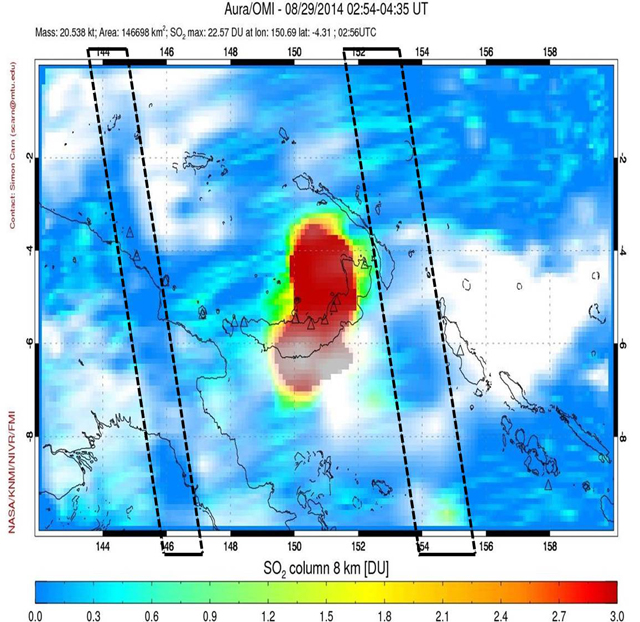 |
Figure 64. OMI SO2 image for the Rabaul eruption captured between 0254-0435 UTC on 29 August (1254-1435 local), ~9.5 hours after the eruption's onset at 1730 UTC the previous day. According to the automated output, parts of the plume registered greater than ~3 DU (the red area). The plume also extended N to S for ~400 km and covered ~147,000 km2. Inaccuracies in the density (DU) of the plume might have been caused by the OMI row anomalies or the regions between the dotted lines to the E and W of the plume. Courtesy of the NASA MEASURES website. |
According to Simon Carn, various inaccuracies may have appeared in the automated input for the plume altitudes. For example, the OMI data was compiled assuming a plume altitude of 8 km, which differs from the ~18 km altitude of the eruption plume and the ~1 km altitudes of all other ash plumes as noted by the Darwin VAAC. This difference would result in an overestimate of the 29-30 August total column masses and an underestimate of all other total column masses. Cloud cover may have also affected the estimates. When a meteorological cloud resides either above or below the volcanogenic SO2 gas plume, the total column mass estimate may be, respectively, underestimated or overestimated. Carn computed and adjusted to compensate for these complicating factors, resulting in a more accurate (but still preliminary) estimate for the SO2 column mass at 18.5 kt, or ~2 kt less than the original measurement of ~20.5 kt. For greater details regarding these and other inaccuracies in images processed with automated algorithms, see the Reventador report in BGVN 39:07 and the reference list therein.
Darwin VAAC Advisories. The Darwin VAAC issued Support to Aviation Control Service SO2 (SACS SO2) and Volcanic Ash Advisories (VAA) beginning at 0848 on 29 August (2248 UTC on 28 August). Regular updates continued through mid-day on 31 August. During the immediate aftermath, the SO2 was similar in location to the ash plume (figure 65). The Aviation Color Code was raised from Orange to Red during the eruption, but was later returned to Orange.
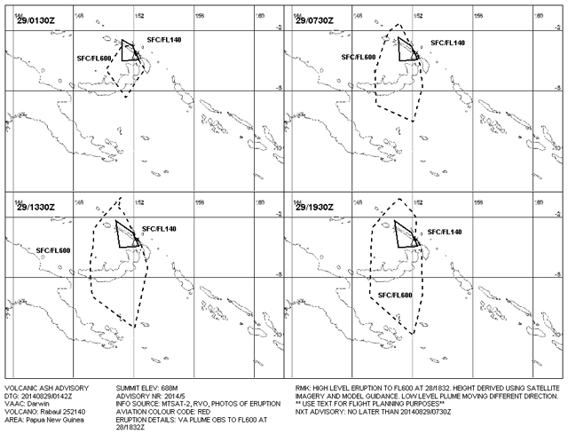 |
Figure 65. Ash movement forecasts shown for 6-hour intervals starting at 1142 LT (0142 UTC) on 29 August. (Read panels from left to right on both rows starting at the top left.) The ash (and/or SO2) movement was projected to advance to the NW, W, SW, and S at comparatively slow velocities. Abbreviations located below the forecast include SFC (ground surface) and FL (flight level, where FL100 would correspond to 10,000 ft). Courtesy of Darwin VAAC. |
Videos. Several videos were taken of the 29 August eruption and post-eruption phases. One impressive video was made from a moving boat looking NE across Blanche bay, taken during daylight hours well after the initial violent Strombolian phase of the 29 August eruption. GVP was unable to establish direct contact with the videographers, Phil and Linda McNamara, leaving open questions about the video's acquisition time and other details. The video, originally posted on 5 September, had received over 6 million views by 8 September according to Daily Mail, perhaps owing to a sharp, loud explosion and shock wave that was recorded, followed by the impact of ballistic material into the bay between the boat and Tavurvur. Many lower quality versions of the video are now online containing misleading artifacts, but the one posted by Bacobjee (2014) was labeled HD (720p) and plays at a rate of 30 frames per second.
A compilation of video clips recorded by Christopher Hamilton (figure 66) from a boat, the Obelisk, located S of Tavurvur in Blanche Bay shows the progression of activity during the main explosive event (table 16). Hamilton stated that he was on board and asleep on the night of 29 August when he was "woken up by golf ball-sized pumice and heavy ash coming through the hatches of the boat." Hamilton recorded the activity, and provided GVP with additional footage not available online.
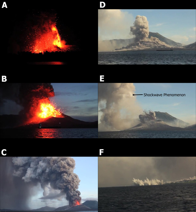 |
Figure 66. A set of still images from a video of the 29 August 2014 Tavurvur eruption at Rabaul captures different eruptive stages during both darkness and daylight. Images were taken from a video compilation of high-definition clips posted on Flickr (Hamilton, 2014). |
Table 16. Christopher Hamilton's videos documenting Rabaul's 29 August eruption are briefly discussed in the text. Most of the described activity can be seen in both videos, but some activity for 0739 and 0750 was only present on the non-public video provided by Hamilton, along with other observations as noted. Still image designation refers to figure 66. All video times have been adjusted to local time. All heights are in altitude.
| Time | Still Image | Video Details |
| 0441 | A | Glowing fountain rose to ~0.7 km. Yellow center surrounded by massive zone of red ejections with many arcing ballistics. The provided video contains views of small discrete lingering ash clouds up to ~0.1 km in diameter. Main, larger ash plume difficult to distinguish and may have been largely outside the field of view. The cone's upper surfaces glowed red and yellow with the growth of spatter-fed lava flows. |
| 0532 | B | Yellow center of columnar glowing fountain rose to ~0.5 km. Ash plume extended well beyond frame and portions moved rapidly upwards. Visible ash clouds progressively lightened from black to light gray overhead and were traversed by several lightning flashes. |
| 0543 | C | Outstanding view of both Tavurvur and Rabaul town using wide angle lens. Reddish glow visible from cone rim to at least ~0.5 km. Gray ash plume rose to ~2.1 km and then curved left. In the provided video, the plume suddenly changed from gray below to white above at ~2.7 km elevation. Diffuse, gray ashfall returned to ground in far left and cone was covered with dusty light clouds. |
| 0739 | -- | Thin, white cloud released. Summit hidden by Turanguna peak in forefront. |
| 0750 | -- | Gray plume erupted to ~0.5 km. Reddish lava ejections formed ashfall. Cone was covered with lumpy cloudlike matter. |
| Unknown | D | Gray plume rose to ~0.8 km. Cone was covered in dense clouds. |
| 0754 | E | Gray plume erupted to ~0.5 km and continued to progress upwards (in provided video) to ~0.9 km. Reddish lava ejections formed ashfall. Material descended the cone. Internal shockwave phenomenon (2 seconds later) moved slowly at ~17 m/s. Clouds crossed by shockwave to the left of cone appeared lighter in color. |
| 0758 | F | Zoom of reddish lava ejections which spread outwards in sheet, before rapidly forming a volley of distinct ballistics. When these landed, they resulted in dusty ejecta on land and upward-jetting splashes of water in Blanche bay. |
References. Bacobjee, 5 September 2014, Volcanic Eruption in Papua New Guinea, Youtube (URL: http://www.youtube.com/watch?v=BUREX8aFbMs) [accessed in November 2014]
Daily Mail, 8 September 2014, (URL: http://www.dailymail.co.uk/sciencetech/article-2747577/Holy-smokes-Watch-explosive-moment-volcano-erupts-triggers-SONIC-BOOM-sending-shockwaves-sky.html) [accessed in February 2015]
Giddings, T. E., Rusak, Z., & Fish, J., 2001, A transonic small-disturbance model for the propagation of weak shock waves in heterogeneous gases, Journal of Fluid Mechanics [accessed in February 2015]
Headlines America, 6 September 2014, (URL: http://www.headlinesamerica.com/holy-smoking-toledos-tourists-capture-video-of-volcano-erupting) [accessed in December 2014]
Hamilton, Christopher, 2 September 2014, Rabaul Volcanic Eruption, Flickr/Leah Chris (URL: http://www.flickr.com/photos/125506007@N06/14935764197/) [accessed in November 2014]
Nave, Carl R., 2014, Speed of Sound in Air, Hyperphysics, (URL: http://hyperphysics.phy-astr.gsu.edu/hbase/sound/souspe.html) [accessed in March 2015]
News.com.au, 29 August 2014, PNG Volcano Tavurvur eruption may disrupt Australian flights, News.com.au (URL: http://www.news.com.au/travel/travel-updates/png-volcano-tavurvur-eruption-may-disrupt-australian-flights/story-e6frfq80-1227040827996) [accessed in November 2014]
Revkin, AC, 4 September 2014, Dynamic Planet: Under the Volcano in Papua New Guinea, The New York Times/ Opinion Pages/ Dot Earth, (URL: http://dotearth.blogs.nytimes.com/2014/09/04/dynamic-planet-under-the-volcano-in-papua-new-guinea/) [accessed in February 2015]
Geological Summary. The low-lying Rabaul caldera on the tip of the Gazelle Peninsula at the NE end of New Britain forms a broad sheltered harbor utilized by what was the island's largest city prior to a major eruption in 1994. The outer flanks of the asymmetrical shield volcano are formed by thick pyroclastic-flow deposits. The 8 x 14 km caldera is widely breached on the east, where its floor is flooded by Blanche Bay and was formed about 1,400 years ago. An earlier caldera-forming eruption about 7,100 years ago is thought to have originated from Tavui caldera, offshore to the north. Three small stratovolcanoes lie outside the N and NE caldera rims. Post-caldera eruptions built basaltic-to-dacitic pyroclastic cones on the caldera floor near the NE and W caldera walls. Several of these, including Vulcan cone, which was formed during a large eruption in 1878, have produced major explosive activity during historical time. A powerful explosive eruption in 1994 occurred simultaneously from Vulcan and Tavurvur volcanoes and forced the temporary abandonment of Rabaul city.
Information Contacts: Rabaul Volcano Observatory, Department of Mineral Policy and Geohazards Management, Volcanological Observatory Geohazards Management Division, P.O. Box 386, Kokopo, East New Britain Province, Papua New Guinea; Darwin Volcanic Ash Advisory Centre (VAAC) (URL: http://www.bom.gov.au/info/vaac/); Jesse Allan and Adam Voiland, NASA Earth Observatory (URL: http://earthobservatory.nasa.gov); NASA MEASURES (URL: https://so2.gsfc.nasa.gov/); Simon Carn, Department of Geological and Mining Engineering and Sciences, Michigan Technological University, Houghton, MI 49931 USA (URL: https://so2.gsfc.nasa.gov/) and Global Volcanism Program, Smithsonian Institution, National Museum of Natural History, Washington, DC; William C. Burton, US Geological Survey, 12201 Sunrise Valley Dr, Reston, Virginia 20192; Christopher Hamilton, CHPhotographic (URL: http://www.chphotographic.com/).