Report on Lokon-Empung (Indonesia) — December 2015
Bulletin of the Global Volcanism Network, vol. 40, no. 12 (December 2015)
Managing Editor: Edward Venzke.
Research and preparation by Paul Berger.
Lokon-Empung (Indonesia) Small eruptions and seismic unrest continue in 2014-2015
Please cite this report as:
Global Volcanism Program, 2015. Report on Lokon-Empung (Indonesia) (Venzke, E., ed.). Bulletin of the Global Volcanism Network, 40:12. Smithsonian Institution. https://doi.org/10.5479/si.GVP.BGVN201512-266100
Lokon-Empung
Indonesia
1.358°N, 124.792°E; summit elev. 1580 m
All times are local (unless otherwise noted)
Frequent activity at Lokon-Empung since early 2011 has typically included small explosions amid seismic unrest. Eruptions from the active Tompaluan crater, in the saddle between the peaks of Lokon and Empung, took place during September 2012-September 2013, May 2015, and August-September 2015. The volcano is monitored by the Pusat Vulkanologi dan Mitigasi Bencana Geologi (PVMBG). The Alert Level has been set at 3 (on a 4 level system) since July 2011, and residents and tourists have been warned not to approach the crater within a radius of 2.5 km.
Activity during 2011-2014. A brief explosion on 11 February 2011 was followed by an eruptive period lasting a year, from 26 June 2011 through 1 May 2012. Activity resumed again on 15 September 2012, and was continuing as of mid-April 2013 (BGVN 38:03). Although there were no further reports of explosive activity until September, thermal anomalies were observed on 5 July 2013 (2 pixels) at or near Tompaluan Crater, based on MODIS satellite data analyzed using MODVOLC.
An ash plume rising to an altitude of 1.8 km and drifting N on 9 September 2013 was reported by the Darwin Volcanic Ash Advisory Centre (VAAC) based on ground reports from PVMBG. Ash was not detected in satellite images due to meteorological clouds. According to a news article (Jakarta Post), an explosion at 0630 generated an ash plume that rose 1.5 km; the explosion was heard 10 km away. Darwin VAAC noted that during the next day, ash plumes rose to an altitude of 2.4 km, although ash was again not identified in satellite images. A spokesperson from the PVMBG told the Jakarta Post that activity declined after 9 September, including the frequency of deep and shallow volcanic earthquakes.
A year later, PVMBG reported that during 8-14 September 2014 observers saw white plumes rising 25-100 m above Tompaluan Crater. On 13 September three explosions from the crater, at 0300, 1146, and 1229, produced thick white plumes that rose at most 500 m above the crater. Seismicity decreased sharply after the 13 September events, but continued to remain high relative to the levels detected previously.
Activity during 2015. According to PVMBG, observers saw white plumes rising 25-50 m above Tompaluan Crater during 6-13 May 2015, although bad weather often prevented observations. Seismicity fluctuated but slightly decreased overall.
An eruption on 20 May 2015 from the crater generated an ash plume that, according to the Darwin VAAC, rose as high as 3 km and drifted NNW (figure 17). The eruption was accompanied by loud "thumping" noises heard at the local observation post. During 21-27 May, thick grayish-white plumes rose as high as 150 m. Bad weather prevented satellite views. Seismicity fluctuated but generally continued to decrease slightly.
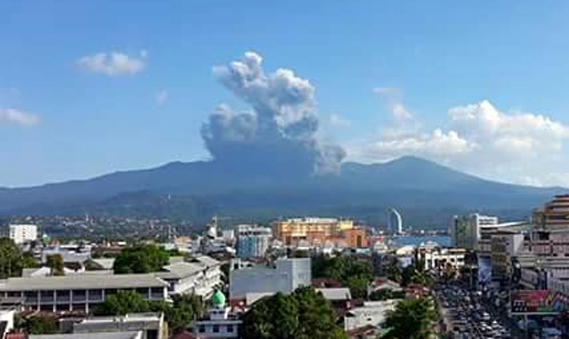 |
Figure 17. Photo of Lokon-Empung erupting on 20 May 2015. The Lokon cone is hidden by the ash plume from Tompaluan Crater; Gunung Empung is to the right. View is approximately NNW from Tomohon City. Courtesy of Piet Hein Pusung. |
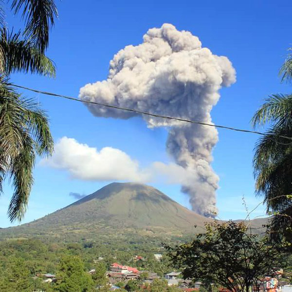 |
Figure 18. Photo of Lokon-Empung erupting on 20 May 2015. The ash plume from Tompaluan Crater is rising above Gunung Lokon (left). View is approximately NNW from Tomohon City. Courtesy of Piet Hein Pusung. |
PVMBG reported that during 10-17 June 2015, observers at the Lokon Observation Post in Kakaskasen Tomohon (4 km from the crater), saw white plumes rising as high as 450 m above the crater. The number of volcanic earthquakes fluctuated and signals indicating emissions were detected almost daily. During 15-22 July observers saw white plumes rising as high as 75 m above the crater. The number of volcanic earthquakes declined but still remained higher than levels recorded during 25 May-10 July. Signals indicating emissions were occasionally detected.
According to the Darwin VAAC, PVMBG reported that on 30 August an ash plume rose to an altitude of 3 km. Ash was not identified in satellite images. According to a news account (Jakarta Post), ashfall occurred in Manado (15 km N) to North Minahasa (43 km NE). Another news account (Regional kompas.com) reported that thick volcanic ash covered the runways at Sam Ratulangi Airport in Manado, delaying some flights.
Thermal anomalies at or near Tompaluan Crater, based on MODIS satellite instruments analyzed using the MODVOLC algorithm, were observed on 24 September 2015 (1 pixel). The MIROVA (Middle InfraRed Observation of Volcanic Activity) system detected six hotspots within 5 km of Lokon-Empung during September 2015, two early in the month and four near the end.
Although inclement weather sometimes obscured views, PVMBG reported that during 28 October-24 November 2015 observers saw white plumes rising as high as 400 m above the crater. Seismicity fluctuated, but the seismic spectral amplitude measurement (SSAM) showed a gradually increasing trend.
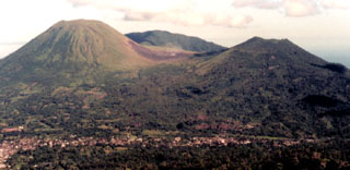
Geological Summary. The Lokong-Empung volcanic complex, rising above the plain of Tondano in North Sulawesi, includes four peaks and an active crater. Lokon, the highest peak, has a flat craterless top. The morphologically younger Empung cone 2 km NE has a 400-m-wide, 150-m-deep crater that erupted last in the 18th century. A ridge extending 3 km WNW from Lokon includes the Tatawiran and Tetempangan peaks. All eruptions since 1829 have originated from Tompaluan, a 150 x 250 m crater in the saddle between Lokon and Empung. These eruptions have primarily produced small-to-moderate ash plumes that sometimes damaged croplands and houses, but lava-dome growth and pyroclastic flows have also occurred.
Information Contacts: Pusat Vulkanologi dan Mitigasi Bencana Geologi (PVMBG, also known as Center of Volcanology and Geological Hazard Mitigation (CVGHM), Jalan Diponegoro 5+7, Bandung 40122, Indonesia (URL: http://www.vsi.esdm.go.id/); Darwin Volcanic Ash Advisory Centre (VAAC), Bureau of Meteorology, Northern Territory Regional Office, PO Box 40050, Casuarina, NT 0811, Australia (URL: http://www.bom.gov.au/info/vaac/); Hawai'i Institute of Geophysics and Planetology (HIGP) MODVOLC Thermal Alerts System, School of Ocean and Earth Science and Technology (SOEST), Univ. of Hawai'i, 2525 Correa Road, Honolulu, HI 96822, USA (URL: http://modis.higp.hawaii.edu/); MIROVA, a collaborative project between the Universities of Turin and Florence, Italy (URL: http://www.mirovaweb.it/); The Jakarta Post (URL: http://www.thejakartapost.com/); Jakarta Globe (URL: http://jakartaglobe.id/); Regional Kompas.com (URL: http://regional.kompas.com/); Piet Hein Pusung (URL: https://twitter.com/PietHeinPusung).