Report on Fuego (Guatemala) — October 2017

Bulletin of the Global Volcanism Network, vol. 42, no. 10 (October 2017)
Managing Editor: Edward Venzke.
Edited by A. Elizabeth Crafford.
Fuego (Guatemala) Six eruptive episodes with Strombolian fountains, lava flows, ash plumes, and pyroclastic flows during July-December 2016
Please cite this report as:
Global Volcanism Program, 2017. Report on Fuego (Guatemala) (Crafford, A.E., and Venzke, E., eds.). Bulletin of the Global Volcanism Network, 42:10. Smithsonian Institution. https://doi.org/10.5479/si.GVP.BGVN201710-342090
Fuego
Guatemala
14.473°N, 90.88°W; summit elev. 3763 m
All times are local (unless otherwise noted)
Volcán de Fuego has been erupting continuously since 2002. Historical observations of eruptions date back to 1531, and radiocarbon dates are confirmed back to 1580 BCE. These eruptions have resulted in major ashfalls, pyroclastic flows, lava flows, and damaging lahars. Fuego was continuously active from January to June 2016. Daily explosions that generated ash plumes to within 1 km above the summit (less than 5 km altitude) were typical. In addition, there were ten eruptive episodes that included Strombolian activity, lava flows, pyroclastic flows, and ash plumes rising above 5 km altitude (BGVN 42:06). Every month, lahars flowed down several drainages. This report continues with a summary of similar activity during July-December 2016. In addition to regular reports from the Instituto Nacional de Sismologia, Vulcanología, Meteorología e Hidrologia (INSIVUMEH), the Washington Volcanic Ash Advisory Center (VAAC) provides aviation alerts. Locations of many towns and drainages are listed in table 12 (BGVN 42:05).
Activity during July-December 2016 was very similar to the previous six months. Background activity included daily explosions, and ash emissions that often generated minor ashfall in communities within 15 km, generally to the SW. Strombolian activity sent material 300 m above the crater, and block avalanches down the flanks. Six eruptive episodes occurred during the second half of 2016, with characteristics very similar to the ten that occurred during the first half of the year (table 13). The episodes usually lasted around 48 hours. During the eruptive episodes, the amplitude and frequency of explosions increased to several per hour, and ash emissions that rose 1-3 km above the summit crater (4.8-7.8 km altitude) distributed ash tens of kilometers away. Diffuse ash plumes were often visible in satellite imagery several hundred kilometers from the volcano. Each episode was also accompanied by Strombolian activity that sent incandescent material 200-500 m above the summit crater, creating lava flows that descended major drainages. Episodes 11 and 16, in July and December, also included pyroclastic flows. The thermal signature recorded in the University of Hawaii's MODVOLC thermal alert system closely correlated with the increased heat flow from the lava flows during the eruptive episodes. Numerous lahars descended major drainages after heavy rains during August, but no damage was reported. A modest lahar was reported near the end of September.
Table 13. Eruptive episodes at Fuego during 2016. Details of episodes 1-10 are described in BGVN 42:06, episodes 11-16 are discussed in this report. The eruptive episode number is just for 2016 and was assigned by the Instituto Nacional de Sismologia, Vulcanología, Meteorología e Hidrologia (INSIVUMEH).
| Dates | Episode | Max Ash Plume altitude | Ash Plume drift | Ash Plume max distance | Ashfall report locations | Lava Flow drainages | Lava Flow lengths | Incandescence above crater | Pyroclastic Flow drainages |
| 3-5 Jan 2016 | 1 | 6.0 km | SW, SE, S | 40 km | 8-12 km SW and SE | Las Lajas (SE), Trinidad (S), Santa Teresa (S) | 2.5 km | 400 m | -- |
| 19-21 Jan 2016 | 2 | 6.7 km | NE | 90 km | 8-18 km NE, 12 km NW | Las Lajas (SE), Trinidad (S), Santa Teresa (S) | 3 km | 400-500 m | Las Lajas (SE), El Jute (SE) |
| 9-10 Feb 2016 | 3 | 5.2 km | NNW | 40 km | 45 km N, NE | Las Lajas (SE), Trinidad (S), Santa Teresa (S) | 800 m-3 km | 300-400 m | Las Lajas (SE), El Jute (SE) |
| 29 Feb-3 Mar 2016 | 4 | 7.3 km | N | 400 km | 10 km SW, N, NW | Las Lajas (SE), El Jute (SE) | 2-3 km | yes | Las Lajas (SE), El Jute (SE) |
| 26-27 Mar 2016 | 5 | 6.1 km | W | 150 km | 9-12 km, SW, NW | Las Lajas (SE), Santa Theresa (S), Trinidad (SE) | 2.0, 1.3, 1.0 km | 500 m | -- |
| 12-14 Apr 2016 | 6 | 5.8 km | SW | 185 km | 10 km SW | Las Lajas (SE), Santa Theresa (S) | 2.0, 1.0 km | 100-300 m | -- |
| 6-7 May 2016 | 7 | 5.5 km | S, SW, SE | 65 km | 21 km SE | Las Lajas (SE), Trinidad (SE) | 3.0 km, 1.5 km | 300 m | -- |
| 18-19 May 2016 | 8 | 5.5 km | SSW | 90 km | 30 km NW, S, SW, W | -- | -- | -- | Las Lajas (SE), Honda (E) |
| 21-23 May 2016 | 9 | 5.5 km | SW, W, S | 75 km | 8-12 km, SW, ENE | Las Lajas (SE) | 2 km | 200-300 m | -- |
| 24-26 Jun 2016 | 10 | 5.5 km | S, SW, W | 120 km | 8-12 km NW, SW | Las Lajas (SE), El Jute (SE), Taniluyá (SW) | 2.5 km, 2.3 km, 600 m | 300 m | -- |
| 28-29 Jul 2016 | 11 | 5.5 km | SW, W, NW | 250 km | 12 km SW, W, 27 km NW | Santa Teresa, Las Lajas | 1.5 km, 3 km | 500 m | Santa Teresa |
| 6-8 Sep 2016 | 12 | 5.0 km | W, SW | 25 km | SW, W | Las Lajas, Taniluyá | 1.2 km, 500 m | 300 m | -- |
| 27-28 Sep 2016 | 13 | 5.0 km | W, SW | 20 km | -- | Las Lajas, Santa Theresa | 1.5 km, 1.8 km | 300 m | -- |
| 29-30 Oct 2016 | 14 | 7.0 km | W, NW | 110 km | 10 km NW, SW | Las Lajas, Santa Teresa, Taniluyá | 2.0 km, 300 m, 500 m | 400-500 m | -- |
| 20-21 Nov 2016 | 15 | 5.0 km | SSW | 175 km | 8-12 km SW | Trinidad, Ceniza, Las Lajas | 1.0 km, 2.0 km, 2.5 km | 300 m | -- |
| 20-21 Dec 2016 | 16 | 5.2 km | W, SW | 230 km | 8-12 km SW | Santa Teresa, Taniluyá, Trinidad, Las Lajas | 2.5, 2.0, 600, 1.8 | 400 m | 3.5 km Taniluyá |
Activity during July 2016. Explosions of incandescent material from the summit crater of Fuego were constant during July 2016, according to INSIVUMEH. On 5 July, an increase in the number of explosions per hour led to an ash plume rising to 4.5 km altitude and drifting W and SW. Incandescent blocks reached the vegetation on the W flank a few hundred meters from the summit. Ashfall was reported in the villages of Morelia, Santa Sofia, Sangre de Cristo (all around 10-12 km SW), and San Pedro Yepocapa (9 km NW). Another increase in activity on 15 July resulted in eight weak-to-moderate explosions per hour, which generated ash plumes that rose to about 4.3-4.8 km altitude and drifted more than 15 km W and SW; ash fell on the flanks in those directions. The Washington VAAC reported ash emissions rising to 4.6-5.2 km altitude, and MODVOLC issued one thermal alert. On 17 July, the Washington VAAC reported an ash emission drifting about 18 km W at 4.9 km altitude. Another ash emission was observed in satellite imagery on 19 July, at 5.2 km altitude drifting NW. The Washington VAAC also reported that the webcam showed lava on the flank near the summit that day.
Eruptive episode 11 began on 28 July 2016 and lasted for about 48 hours. Moderate-to-strong explosions expelled ash plumes to 5.5 km altitude that eventually drifted more than 250 km SW, W, and NW. The INSIVUMEH webcam at Finca La Reunion (SE) captured an image of the ash plume accompanied by a pyroclastic flow which descended the Santa Teresa ravine (barranca) around midday on 29 July (figure 50). Incandescent material was ejected about 500 m above the crater and fed two lava flows; one traveled 1.5 km down the Santa Teresa ravine, and the other traveled 3 km down the Las Lajas ravine. Some of the villages that reported ashfall included Sangre de Cristo, San Pedro Yepocapa, and Patzún (27 km NW). The Washington VAAC observed the ash plume in the early morning of 29 July extending 30 km WNW from the summit at 5.8 km altitude. By late morning, the plume had risen to 6.7 km altitude and was visible 150 km NW. The plume altitude dropped later in the day to 5.2 km, and the drift direction changed more toward the W. The farthest edge of the plume was faintly visible over 250 km W before it dissipated that evening. Incandescent explosions continued into the night, but had subsided by the next morning. A MODVOLC thermal anomaly signal first appeared on 26 July and persisted through 31 July; there were 17 thermal alert pixels reported on 29 July.
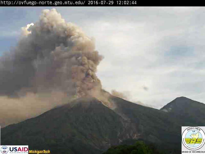 |
Figure 50. An ash plume rises from the summit of Fuego on 29 July 2016 while a small pyroclastic flow descends a drainage on the SE flank, as seen from the Finca la Reunion webcam. Eruptive episode 11 lasted from 28 to 30 July. Courtesy of INSIVUMEH (Informe Mensual De La Actividad Del Volcán Fuego, Julio 2016). |
Activity during August 2016. Weak and moderate explosions that generated ash plumes characterized activity during August 2016. Although a few strong explosions were recorded, there were no distinct eruptive episodes documented by INSIVUMEH. Constant rains, however, led to several lahars descending the major ravines. Persistent steam plumes rose to 4.2 km and drifted W and SW. Weak-to-moderate explosions with ash reached 4.3 to 4.8 km altitude, and drifted more than 15 km SW and W before dissipating. Ashfall was reported primarily in the communities of Sangre de Cristo, Yepocapa, Morelia, Hagia Sophia, and Panimaché I and II. Incandescent material was ejected 300 m above the crater, and generated weak-to-moderate avalanches within the crater.
The Washington VAAC reported an ash plume visible in satellite imagery on 7 August at 4.9 km altitude extending about 10 km WNW from the summit. On 11 August, a narrow plume was spotted in both visible and multispectral imagery extending about 80 km W at the same altitude. A puff of volcanic ash appeared in clear satellite and webcam images drifting W at 4.9 km on 19 August. A series of ash emissions were spotted on 20 August in satellite imagery. The head of the plume was about 35 km W of the summit. The highest altitude plume reported by the Washington VAAC during August was at 5.8 km on 25 August, drifting 25 km W. A single MODVOLC thermal alert was also recorded that day. On 15 and 16 August moderate-to-large lahars descended the Las Lajas and El Jute ravines, carrying blocks as large as 3 m in diameter, tree trunks, branches, and other debris. Another lahar recorded on 28 August descended the Santa Teresa tributary of the Pantaleón River, where the residents noted the warm temperature of the debris.
Activity during September 2016. Two eruptive episodes took place during September 2016. Episode 12 began on 6 September and lasted about 48 hours. Moderate-to-strong explosions generated ash plumes that rose to 5 km altitude and drifted 25 km W and SW. Incandescent material rose to 300 m above the crater and fed two lava flows, one traveled 1.2 km down the Las Lajas ravine (figure 51), and the other travelled 500 m down the Taniluyá. The Washington VAAC reported an ash plume, identified in satellite imagery, on 7 September moving WSW at 4.9 km altitude. MODVOLC thermal alerts were issued during 4-8 September, with 10 alerts appearing on 8 September.
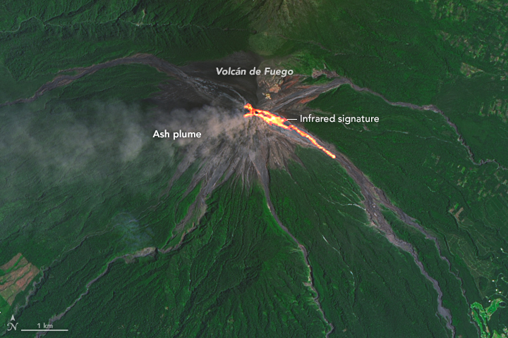 |
Figure 51. On 7 September 2016, the Operational Land Imager (OLI) on Landsat 8 captured this image of lava flowing down the Las Lajas and Santa Teresa ravines at Fuego during eruptive episode 12. The image is a composite of natural color (OLI bands 4-3-2) and shortwave Infrared (OLI band 7). Shortwave infrared light (SWIR) is invisible to the naked eye, but strong SWIR signals indicate increased temperatures. Courtesy of NASA Earth Observatory. |
A bright hotspot in satellite imagery was reported by the Washington VAAC on 25 September 2016. A modest lahar descended the Santa Teresa ravine on 26 September, carrying 50-cm-diameter blocks, branches, and tree trunks; it was 10 m wide and 1 m high. Eruptive episode 13 began the next day, 27 September 2016, with moderate-to-strong explosions, and an ash plume that rose to 5 km altitude and drifted more than 20 km W and SW (figure 52). Incandescent material rose 300 m above the crater, feeding two lava flows. Lava traveled 1.5 km down the Las Lajas ravine (figure 53) and 1.8 km down the Santa Teresa ravine. A fissure developed on the S flank of the crater rim, and new fumarolic activity was observed during the day. Constant rumbling noises were audible in the areas of Finca Palo Verde, Sangre de Cristo, and San Pedro Yepocapa on the W and SW flanks. The Washington VAAC reported an intense hotspot in shortwave imagery. Activity subsided on 28 September. A strong multi-pixel thermal alert signal appeared in the MODVOLC data from 24-29 September.
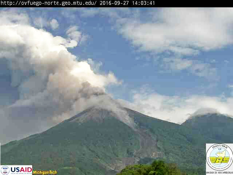 |
Figure 52. An ash emission rises to 5 km altitude on 27 September 2016 at Fuego during eruptive episode 13. Courtesy of INSIVUMEH (Informe Mensual De La Actividad Del Volcán Fuego, Septiembre 2016). |
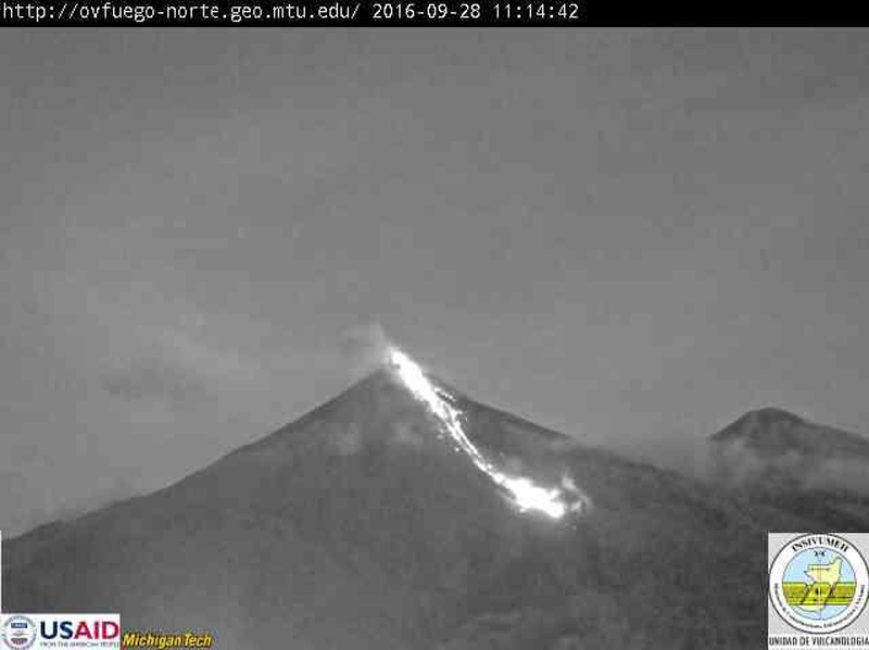 |
Figure 53. Lava flows down the Las Lajas barranca (ravine) at Fuego on 28 September 2016 during eruptive episode 13. Courtesy of INSIVUMEH (Informe Mensual De La Actividad Del Volcán Fuego, Septiembre 2016). |
Activity during October 2016. Six to ten explosions per day were recorded at Fuego during October 2016. Some of them generated ashfall on the SW flank. Episode 14, which began at the end of the month, produced three lava flows and strong explosions with an ash plume that rose to 7 km altitude and drifted N and NW. The Washington VAAC reported multiple ash emissions at 5.2 km altitude on 3 October, with the furthest one extending 35 km S. The next day, ash emissions were observed at 4.9 km altitude and drifted 22 km SSE. Pyroclastic flows were seen in an INSIVUMEH webcam on 10 October. They also reported ashfall in nearby communities that day.
Incandescent material rose 150-200 m above the summit crater on 28 October, and lava traveled 500 m down the Las Lajas ravine. Episode 14 began the next day with a strong explosion that generated an ash plume to 7 km altitude that drifted 110 km W and NW. Constant loud rumbling was reported up to 15 km from the volcano, and ashfall was reported in San Pedro Yepocapa, Sangre de Cristo, and La Conchita. Three incandescent lava fountains were seen in the early hours of 30 October (figure 54). The first, 450 m above the crater, fed a 2-km-long flow in the Las Lajas ravine. The second fountain rose to 250 m and fed a flow that traveled 300 m down the Santa Teresa canyon. The third fountain rose 200 m and formed a flow that traveled down the Taniluyá drainage for 500 m. Activity declined during the night of 30 October, but weak and moderate avalanches of incandescent material continued into the first part of the next day.
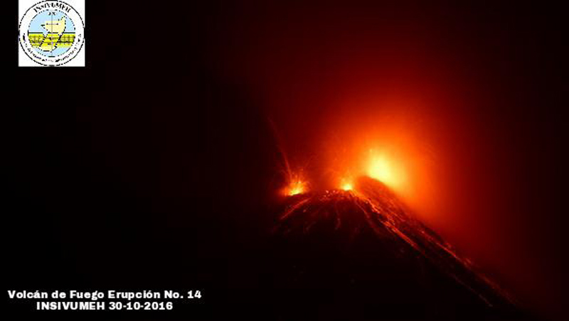 |
Figure 54. Three Strombolian fountains at Fuego feed three lava flows on 30 October 2016 during eruptive episode 14. Courtesy of INSIVUMEH (Informe Mensual De La Actividad Del Volcán Fuego, Octubre 2016). |
The first ash emissions of episode 14 were visible in satellite imagery on 29 October, extending roughly 45 km NNW from the summit. By early the next day, the ash emissions were detected at 7.3 km altitude, based on a pilot report. They extended about 110 km NNW from the summit. Later in the day, the plume had lowered to 5 km altitude and drifted 15 km N and NW. A single MODVOLC thermal alert was reported on 13 October, but a lengthy series of multi-pixel alerts were generated during 24-31 October, including 19 pixels on 30 October at the peak of episode 14.
Activity during November 2016. Activity during November 2016 remained at background levels until the third week of the month; explosions increased in amplitude and frequency to as many as 15 per hour, leading to episode 15 which began on 20 November. The background levels of the second and third weeks included incandescent material rising to 300 m above the crater, causing avalanches down the flanks around the crater rim and continuous explosions of weak-to-moderate energy that generated ash plumes rising to altitudes between 4.3 and 4.7 km that drifted W and SW.
The Washington VAAC reported ash emissions in satellite imagery every day from 8 to15 November 2016. A plume was seen on 8 November rising to 4.6 km altitude and drifting 25 km SW. The next day, a plume at the same altitude drifted 45 km NW. On 10 November, a faint plume was seen in visible imagery, extending about 25 km NNW. A larger plume was visible in morning imagery on 11 November at 5.5 km altitude extending 35 km WSW. The next day, at the same altitude, a diffuse plume was visible 10 km W of the summit. Multiple emissions were spotted drifting W from the summit at 4.6-4.9 km altitude on 13 and 14 November. Two single MODVOLC thermal alerts were reported on 12 and 14 November. A hotspot was detected in satellite imagery on 15 November, along with continuing emissions to 4.6 km altitude that drifted within 10 km SW of the summit. On 17 November ashfall was reported in Morelia, Santa Sofia, and Panimache I and II. Emissions on 18 November rose to 4.7 km altitude and drifted 10 km SW, and on 20 November they rose to 4.9 km altitude and drifted 24 km from the summit (figure 55).
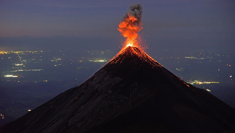 |
Figure 55. Strombolian eruption and ash emission at Fuego, looking S from Acatenango summit on the early morning of 18 November 2016. Photo copyright by Martin Rietze, used with permission. |
Eruptive episode 15 began on 20 November with strong explosions that caused ash plumes to rise to 5 km altitude and drift as far as 175 km SSW and W, generating ashfall again in Morelia, Santa Sofia, and Panimache I and II. Three lava flows emerged from the 300-m-high Strombolian ejections; one traveled 1 km down the Trinidad ravine, one descended 2 km down barranca Ceniza, and the third flowed 2.5 km down barranca Las Lajas (figure 56). Numerous clouds of volcanic ash rose from block avalanches in Las Ceniza ravine on 20 and 21 November.
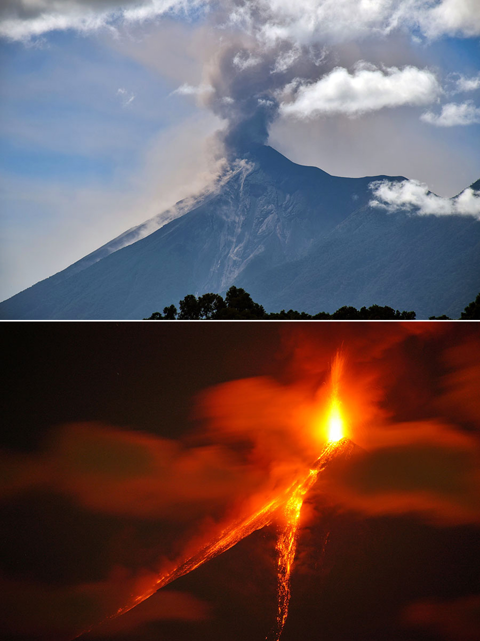 |
Figure 56. Eruptive episode 15 at Fuego occurred during 20-21 November 2016. An ash plume rose to 5 km altitude (top) before Strombolian activity 300 m high sent flows down three major ravines (bottom). These views from the rooftop of a hostel in Antigua (18 km NE) show the ravines in daylight during the afternoon of 20 November, and again around midnight that night as the incandescent material traveled downward. Photos copyright by Martin Rietze, used with permission. |
The Washington VAAC reported an extremely large hotspot on 20 November 2016 (local time) in infrared imagery, along with ash emissions at 4.9 km altitude drifting SW to 65 km. Emissions at 3.8 km persisted into the night. By early morning on 21 November, they were visible extending 175 km W. A lengthy period of multi-pixel MODVOLC thermal alerts coincided with eruptive episode 15 during 17-23 November, and included 26 pixels on 21 November 2016. Eruptive activity decreased to background levels by 22 November, and only weak explosions and fumarolic activity were reported for the rest of the month.
Activity during December 2016. Weak-to-moderate explosions and ash plumes characterized background activity at Fuego during December 2016. Minor ashfall was regularly reported in communities located 8-12 km SW. Activity increased somewhat during 15-16 December, and eruptive episode 16 was recorded during 20-21 December. During episode 16, Strombolian activity created three lava flows that descended major ravines, and a large pyroclastic flow traveled 3.5 km from the summit, burning vegetation in its path.
The Washington VAAC reported an ash emission on 5 December at 5.8 km altitude drifting N. On 8 December, intermittent ash plumes were drifting W over the East Pacific Ocean at 6.1 km altitude. Remnants over 450 km W were seen in multispectral imagery by early on 9 December. Multiple new detached plumes continued moving WNW between 5.5 and 6.1 km altitude on 9 December. They were 80 km NW by late afternoon. New discrete emissions at 4.6 km altitude appeared in satellite imagery on 10 December, drifting W up to 130 km before dissipating.
During the afternoon of 20 December 2016, eruptive episode 16 began with moderate-to-strong ash emissions producing an ash plume that rose to 4.7 km altitude and drifted more than 15 km W and SW. Incandescent material rose 400 m above the crater, and bombs fell more than 300 m away. Block avalanches were concentrated in the Ceniza and Trinidad ravines. By the evening of 20 December, three lava flows had formed, in the Santa Teresa, the Taniluyá, and the Las Lajas ravines (figure 57). By the morning of 21 December, they were 2.5, 2.0, and 1.8 km long, respectively. During that day, strong explosions generated ash plumes that rose to 5.2 km altitude and drifted 18 km S, SW, W, and NW. Some of the communities that reported ash from this event included Panimaché, Morelia, Santa Sofia, Sangre de Cristo, San Pedro Yepocapa, and Palo Verde.
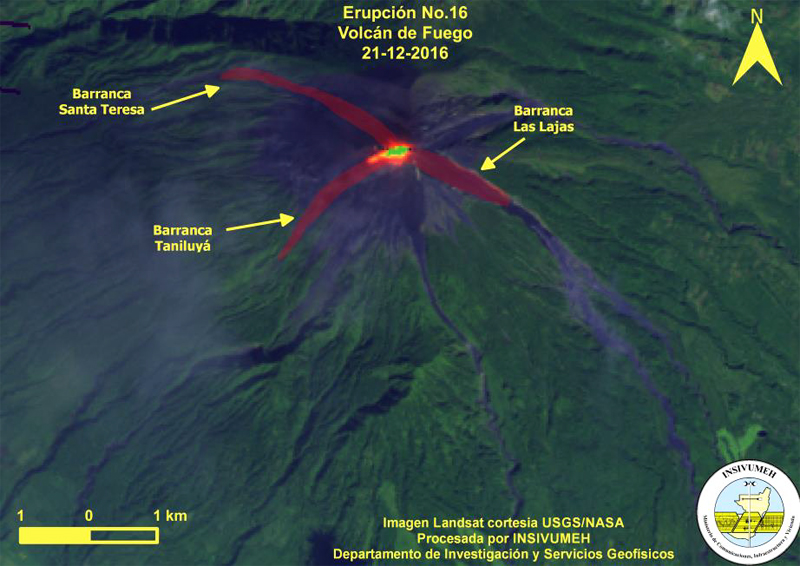 |
Figure 57. Landsat image showing the locations of three lava flows at Fuego during eruptive episode 16 on 21 December 2016. Image courtesy of USGS/NASA, annotations courtesy of INSIVUMEH (Informe Mensual De La Actividad Del Volcán Fuego, Diciembre 2016). |
Around 1000 on 21 December, pyroclastic flows that descended the Taniluyá ravine generated an ash plume that rose 2 km and drifted W and SW. The flows traveled 3.5 km and were estimated to be 300 m wide. They descended the ravine at high speed and high temperature, burning everything in their path (figure 58). These were the first pyroclastic flows in several months. By the end of eruptive episode 16, the lava flow in the Taniluyá ravine had reached 2.8 km in length (figure 59).
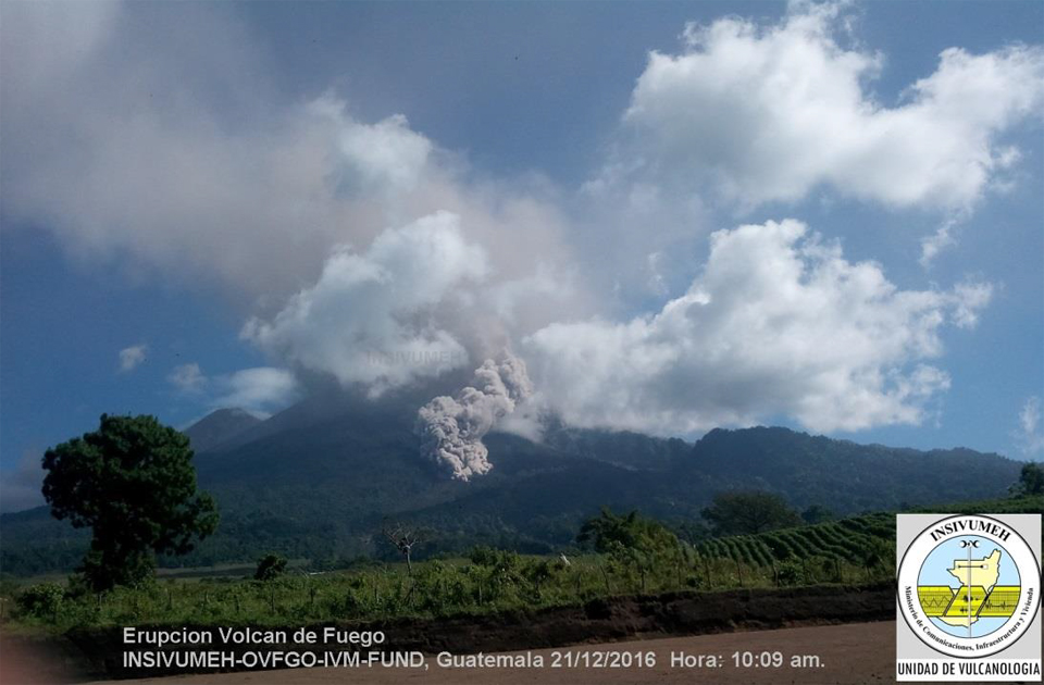 |
Figure 58. A pyroclastic flow descends the Taniluyá ravine around 1000 local time on 21 December 2016 at Fuego during eruptive episode 2016. Courtesy of INSIVUMEH (Informe Mensual De La Actividad Del Volcán Fuego, Diciembre 2016). |
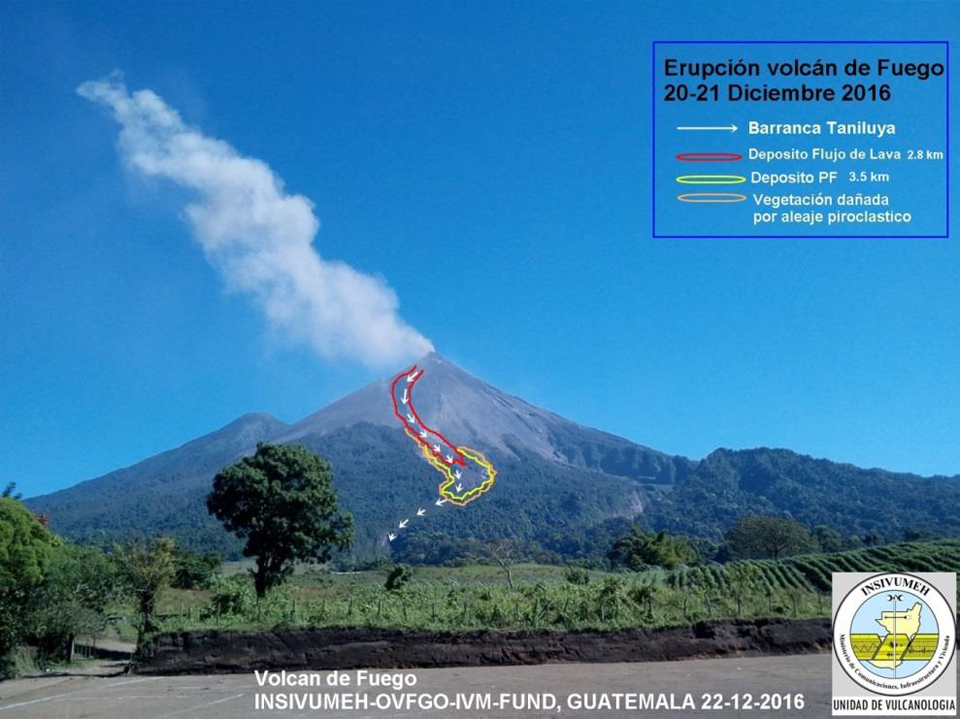 |
Figure 59. Both a pyroclastic flow (3.5 km long, yellow outline) and a lava flow (2.8 km long, red outline) descended the Taniluyá ravine at Fuego during eruptive episode 16, from 20 to 21 December 2016. The white arrows indicate the ravine. The orange outline indicates the area where vegetation was destroyed by the pyroclastic flows. Courtesy of INSIVUMEH (Informe Mensual De La Actividad Del Volcán Fuego, Diciembre 2016). |
During episode 16, the Washington VAAC reported ash emissions rising to 5.2 km (about 1.4 km above the summit crater) altitude and drifting about 230 km SW. Continuing ash emissions on 23 December were visible in satellite imagery moving 45 km SW from the summit at 4.3 km altitude. Intermittent diffuse ash emissions extended up to 30 km WSW and NW from the summit during 28-31 December at 4.3-5.2 km altitude.
MODVOLC thermal alerts were intermittent throughout December. They were recorded on 8 (2), 11 (2), 12, 14 (2), 16 (3), and 18 (3) December prior to episode 16. The biggest interval of multi-pixel alerts was during episode 16 from 20-22 December, and included 14 alerts on 21 December 2016. Additional single alerts were recorded on 25 and 29 December.
Geological Summary. Volcán Fuego, one of Central America's most active volcanoes, is also one of three large stratovolcanoes overlooking Guatemala's former capital, Antigua. The scarp of an older edifice, Meseta, lies between Fuego and Acatenango to the north. Construction of Meseta dates back to about 230,000 years and continued until the late Pleistocene or early Holocene. Collapse of Meseta may have produced the massive Escuintla debris-avalanche deposit, which extends about 50 km onto the Pacific coastal plain. Growth of the modern Fuego volcano followed, continuing the southward migration of volcanism that began at the mostly andesitic Acatenango. Eruptions at Fuego have become more mafic with time, and most historical activity has produced basaltic rocks. Frequent vigorous historical eruptions have been recorded since the onset of the Spanish era in 1524, and have produced major ashfalls, along with occasional pyroclastic flows and lava flows.
Information Contacts: Instituto Nacional de Sismologia, Vulcanologia, Meteorologia e Hydrologia (INSIVUMEH), Unit of Volcanology, Geologic Department of Investigation and Services, 7a Av. 14-57, Zona 13, Guatemala City, Guatemala (URL: http://www.insivumeh.gob.gt/); Washington Volcanic Ash Advisory Center (VAAC), Satellite Analysis Branch (SAB), NOAA/NESDIS OSPO, NOAA Science Center Room 401, 5200 Auth Rd, Camp Springs, MD 20746, USA (URL: http://www.ospo.noaa.gov/Products/atmosphere/vaac/, archive at: http://www.ssd.noaa.gov/VAAC/archive.html); Hawai'i Institute of Geophysics and Planetology (HIGP) - MODVOLC Thermal Alerts System, School of Ocean and Earth Science and Technology (SOEST), Univ. of Hawai'i, 2525 Correa Road, Honolulu, HI 96822, USA (URL: http://modis.higp.hawaii.edu/); NASA Earth Observatory, EOS Project Science Office, NASA Goddard Space Flight Center, Goddard, Maryland, USA (URL: http://earthobservatory.nasa.gov/); Martin Rietze (URL: http://www.mrietze.com/index.htm).