Report on Kuchinoerabujima (Japan) — November 2020

Bulletin of the Global Volcanism Network, vol. 45, no. 11 (November 2020)
Managing Editor: Edward Venzke.
Edited by Kadie L. Bennis.
Kuchinoerabujima (Japan) Intermittent thermal anomalies and small eruptions in May and August 2020
Please cite this report as:
Global Volcanism Program, 2020. Report on Kuchinoerabujima (Japan) (Bennis, K.L., and Venzke, E., eds.). Bulletin of the Global Volcanism Network, 45:11. Smithsonian Institution. https://doi.org/10.5479/si.GVP.BGVN202011-282050
Kuchinoerabujima
Japan
30.443°N, 130.217°E; summit elev. 657 m
All times are local (unless otherwise noted)
Kuchinoerabujima encompasses a group of young stratovolcanoes located in the northern Ryukyu Islands. All historical eruptions have originated from the Shindake cone, with the exception of a lava flow that originated from the S flank of the Furudake cone. The current eruptive period began in January 2020 and has been characterized by small explosions, ash plumes, ashfall, a pyroclastic flow, and gas-and-steam emissions. This report covers activity from May to October 2020, which includes small explosions, ash plumes, crater incandescence, and gas-and-steam emissions. The primary source of information for this report comes from monthly and annual reports from the Japan Meteorological Agency (JMA) and advisories from the Tokyo Volcanic Ash Advisory Center (VAAC).
Volcanism at Kuchinoerabujima remained relatively low during May through October 2020, according to JMA. During this time, SO2 emissions ranged from 40 to 3,400 tons/day; occasional gas-and-steam emissions were reported, rising to a maximum of 900 m above the crater. Sentinel-2 satellite images showed a particularly strong thermal anomaly in the Shindake crater on 1 May (figure 10). The thermal anomaly decreased in power after 1 May and was only visible on clear weather days, which included 19 August and 3 and 13 October. Global Navigation Satellite System (GNSS) observations identified continued slight inflation at the base of the volcano during the entire reporting period.
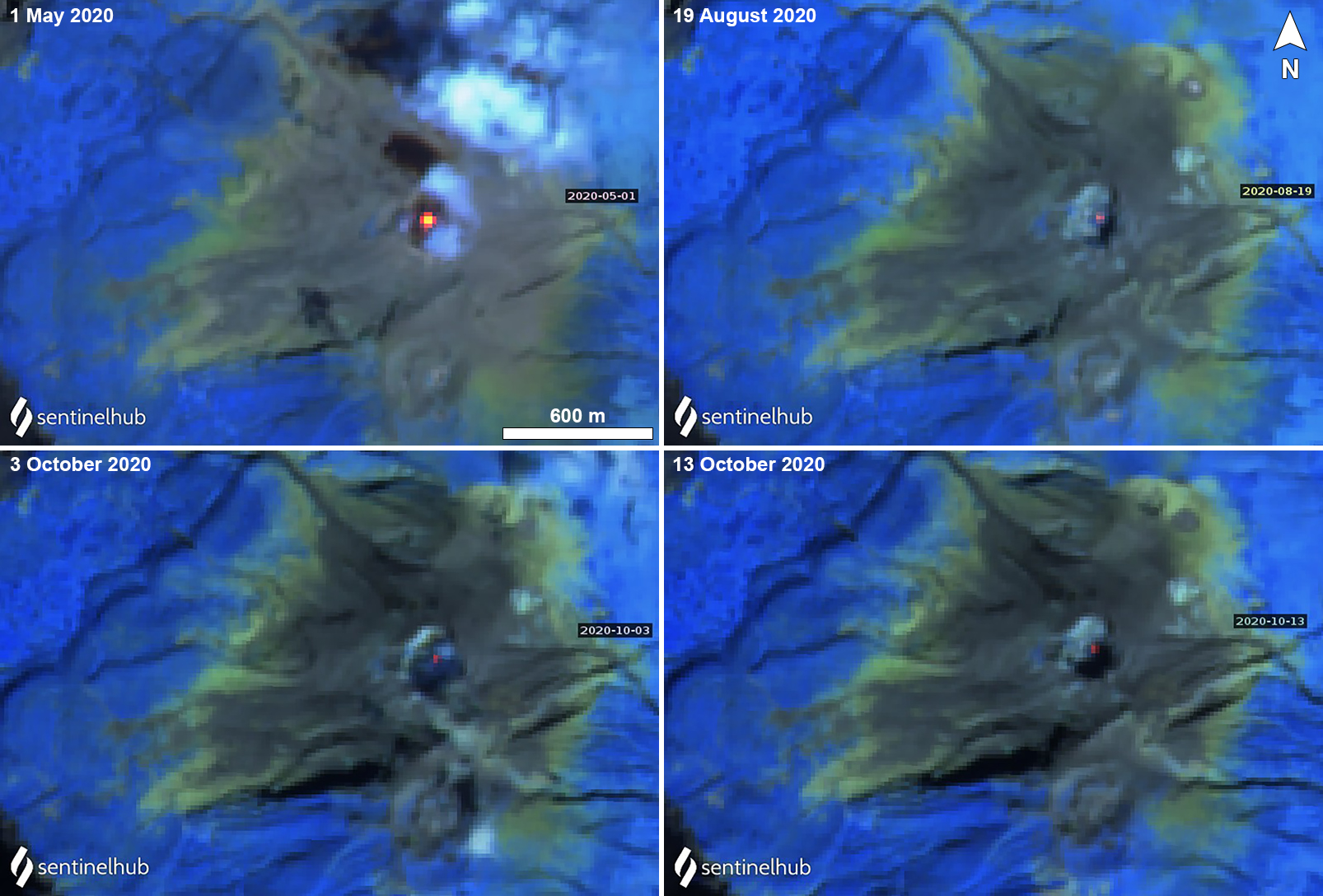 |
Figure 10. Sentinel-2 thermal satellite images showed a strong thermal anomaly (bright yellow-orange) in the Shindake crater at Kuchinoerabujima on 1 May 2020 (top left). Weaker thermal anomalies were also seen in the Shindake crater during 19 August (top right) and 3 (bottom left) and 13 (bottom right) October 2020. Sentinel-2 atmospheric penetration (bands 12, 11, 8A) images; courtesy of Sentinel Hub Playground. |
Three small eruptions were detected by JMA on 5, 6, and 13 May, which produced an ash plume rising 500 m above the crater on each day, resulting in ashfall on the downwind flanks. Incandescence was observed at night using a high-sensitivity surveillance camera (figure 11). On 5 and 13 May the Tokyo VAAC released a notice that reported ash plumes rising 0.9-1.2 km altitude, drifting NE and S, respectively. On 20 May weak fumaroles were observed on the W side of the Shindake crater. The SO2 emissions ranged from 700-3,400 tons/day.
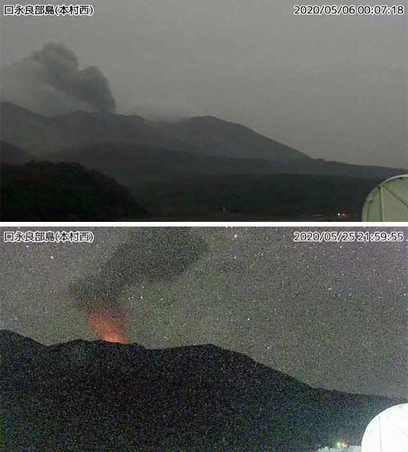 |
Figure 11. Webcam images of an eruption at Kuchinoerabujima on 6 May 2020 (top), producing a gray ash plume that rose 500 m above the crater. Crater incandescence was observed from the summit crater at night on 25 May 2020 (bottom). Courtesy of JMA (Monthly bulletin report 509, May 2020). |
Activity during June and July decreased compared to May, with gas-and-steam emissions occurring more prominently. On 22 June weak incandescence was observed, accompanied by white gas-and-steam emissions rising 700 m above the crater. Weak crater incandescence was also seen on 25 June. The SO2 emissions measured 400-1,400 tons/day. White gas-and-steam emissions were again observed on 31 July rising to 800 m above the crater. The SO2 emissions had decreased during this time to 300-700 tons/day.
According to JMA, the most recent eruptive event occurred on 29 August at 1746, which ejected bombs and was accompanied by some crater incandescence, though the eruptive column was not visible due to the cloud cover. However, white gas-and-steam emissions could be seen rising 1.3 km above the Shindake crater drifting SW. The SO2 emissions measured 200-500 tons/day. During August, the number of volcanic earthquakes increased significantly to 1,032, compared to the number in July (36).
The monthly bulletin for September reported white gas-and-steam emissions rising 900 m above the crater on 9 September and on 11 October the gas-and-steam emissions rose 600 m above the crater. Seismicity decreased between September and October from 1,920 to 866. The SO2 emissions continued to decrease compared to previous months, totaling 80-400 tons/day in September and 40-300 tons/day in October.
Geological Summary. A group of young stratovolcanoes forms the eastern end of the irregularly shaped island of Kuchinoerabujima in the northern Ryukyu Islands, 15 km W of Yakushima. The Furudake, Shindake, and Noikeyama cones were erupted from south to north, respectively, forming a composite cone with multiple craters. All historical eruptions have occurred from Shindake, although a lava flow from the S flank of Furudake that reached the coast has a very fresh morphology. Frequent explosive eruptions have taken place from Shindake since 1840; the largest of these was in December 1933. Several villages on the 4 x 12 km island are located within a few kilometers of the active crater and have suffered damage from eruptions.
Information Contacts: Japan Meteorological Agency (JMA), 1-3-4 Otemachi, Chiyoda-ku, Tokyo 100-8122, Japan (URL: http://www.jma.go.jp/jma/indexe.html); Tokyo Volcanic Ash Advisory Center (VAAC), 1-3-4 Otemachi, Chiyoda-ku, Tokyo 100-8122, Japan (URL: http://ds.data.jma.go.jp/svd/vaac/data/); Sentinel Hub Playground (URL: https://www.sentinel-hub.com/explore/sentinel-playground).