Report on Iliwerung (Indonesia) — December 2021
Bulletin of the Global Volcanism Network, vol. 46, no. 12 (December 2021)
Managing Editor: Edward Venzke.
Edited by Kadie L. Bennis.
Iliwerung (Indonesia) Submarine eruption during 28-29 November 2021
Please cite this report as:
Global Volcanism Program, 2021. Report on Iliwerung (Indonesia) (Bennis, K.L., and Venzke, E., eds.). Bulletin of the Global Volcanism Network, 46:12. Smithsonian Institution. https://doi.org/10.5479/si.GVP.BGVN202112-264250
Iliwerung
Indonesia
8.532°S, 123.573°E; summit elev. 583 m
All times are local (unless otherwise noted)
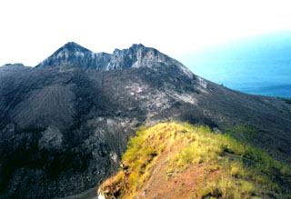
Iliwerung is constructed on the southern rim of the Lerek caldera on the south-facing peninsula on Lembata Island. The summit lava dome was formed during an eruption in 1870. Beginning in 1973-1974, submarine eruptions began from the lower ESE flank Hobal vent, located 2 km from the summit crater. Since then, activity originated from this vent during eruptions in 1983, 1993, 1999, and 2013. The eruption in August 2013 that consisted of diffuse fumarolic emissions, incandescence at sea level, discolored water, and shallow volcanic earthquakes (BGVN 40:05). This report updates activity through December 2021 and describes a submarine eruption during 28-29 November 2021. Information primarily comes from Pusat Vulkanologi dan Mitigasi Bencana Geologi (PVMBG, also known as CVGHM, or the Center of Volcanology and Geological Hazard Mitigation).
A submarine eruption was observed during 28-29 November 2021, which prompted PVMBG to raise the Volcano Alert Level (VAL) to 2 (on a scale of 0-4). Residents reported that the ocean surface was bubbling up to heights of less than 1 m at 2152 on 28 November from a spot 30 m from the shore. This activity lasted about an hour and originated about 1 km SW of the Hobal submarine vent. Bubbling up was also observed at 0517 the next day on 29 November. Additional bubbling water and a plume was noted at 0829 that rose 100 m. Intermittent tremors were also detected, beginning on 29 November and continuing through the end of December.
Geological Summary. Constructed on the southern rim of the Lerek caldera, Iliwerung forms a prominent south-facing peninsula on Lembata (formerly Lomblen) Island. Craters and lava domes have formed along N-S and NW-SE lines on the complex volcano; activity has been observed at vents from the summit to the submarine SE flank. The summit lava dome was formed during an eruption in 1870. In 1948 the Iligripe lava dome grew on the E flank at 120 m elevation. Beginning in 1973-74, when three ephemeral islands were formed, submarine eruptions began on the lower ESE flank at a vent named Hobal; several other eruptions have since taken place at this vent.
Information Contacts: Pusat Vulkanologi dan Mitigasi Bencana Geologi (PVMBG, also known as Indonesian Center for Volcanology and Geological Hazard Mitigation, CVGHM), Jalan Diponegoro 57, Bandung 40122, Indonesia (URL: http://www.vsi.esdm.go.id/).