Report on Erebus (Antarctica) — January 2023

Bulletin of the Global Volcanism Network, vol. 48, no. 1 (January 2023)
Managing Editor: Edward Venzke.
Research and preparation by Paul Berger.
Erebus (Antarctica) Continuing lava lake; slightly decreased thermal activity recorded in 2022 compared to 2021
Please cite this report as:
Global Volcanism Program, 2023. Report on Erebus (Antarctica) (Venzke, E., ed.). Bulletin of the Global Volcanism Network, 48:1. Smithsonian Institution.
Erebus
Antarctica
77.53°S, 167.17°E; summit elev. 3794 m
All times are local (unless otherwise noted)
Erebus, Antarctica’s best known and world’s southernmost active volcano, overlooks the McMurdo research station on Ross Island. It has a lava lake in the summit crater that has been active since at least 1972. Because of the remote location, activity is primarily monitored by satellites. This report covers activity during 2022.
During 2022 the Sentinel-2 satellite only captured images of Erebus during 1 January-8 March and 27 September-26 December (figure 31). The images showed at least three distinct thermal sources within the summit crater. The HIGP MODVOLC Thermal Alerts System recorded more thermal activity during January-May, and lower activity during June-December compared to 2021 (table 8).
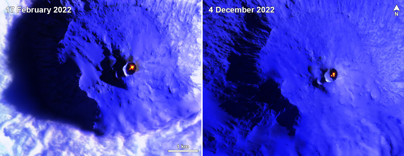 |
Figure 31. Sentinel-2 infrared satellite images showing the active lava lake in the summit crater of Erebus during 2022. The image on 17 February shows a single lava lake, while the image on 4 December shows a larger lake and at least two smaller thermal areas immediately SW. Images use Atmospheric Penetration rendering (bands 12, 11, 8A). Courtesy of Sentinel Hub Playground. |
Table 8. Number of monthly MODIS-MODVOLC thermal alert pixels recorded at Erebus during 2017-2022. See BGVN 42:06 for data from 2000 through 2016. The table was compiled using data provided by the HIGP – MODVOLC Thermal Alerts System.
| Year | Jan | Feb | Mar | Apr | May | Jun | Jul | Aug | Sep | Oct | Nov | Dec | SUM |
| 2017 | 0 | 21 | 9 | 0 | 0 | 1 | 11 | 61 | 76 | 52 | 0 | 3 | 234 |
| 2018 | 0 | 21 | 58 | 182 | 55 | 17 | 137 | 172 | 103 | 29 | 0 | 0 | 774 |
| 2019 | 2 | 21 | 162 | 151 | 55 | 56 | 75 | 53 | 29 | 19 | 1 | 0 | 624 |
| 2020 | 0 | 2 | 16 | 18 | 4 | 4 | 1 | 3 | 18 | 3 | 1 | 6 | 76 |
| 2021 | 0 | 9 | 1 | 0 | 2 | 56 | 46 | 47 | 35 | 52 | 5 | 3 | 256 |
| 2022 | 1 | 13 | 55 | 22 | 15 | 32 | 39 | 19 | 31 | 11 | 0 | 0 | 238 |
Geological Summary. Mount Erebus, the world's southernmost historically active volcano, overlooks the McMurdo research station on Ross Island. It is the largest of three major volcanoes forming the crudely triangular Ross Island. The summit of the dominantly phonolitic volcano has been modified by one or two generations of caldera formation. A summit plateau at about 3,200 m elevation marks the rim of the youngest caldera, which formed during the late-Pleistocene and within which the modern cone was constructed. An elliptical 500 x 600 m wide, 110-m-deep crater truncates the summit and contains an active lava lake within a 250-m-wide, 100-m-deep inner crater; other lava lakes are sometimes present. The glacier-covered volcano was erupting when first sighted by Captain James Ross in 1841. Continuous lava-lake activity with minor explosions, punctuated by occasional larger Strombolian explosions that eject bombs onto the crater rim, has been documented since 1972, but has probably been occurring for much of the volcano's recent history.
Information Contacts: Hawai'i Institute of Geophysics and Planetology (HIGP) - MODVOLC Thermal Alerts System, School of Ocean and Earth Science and Technology (SOEST), Univ. of Hawai'i, 2525 Correa Road, Honolulu, HI 96822, USA (URL: http://modis.higp.hawaii.edu/); Sentinel Hub Playground (URL: https://www.sentinel-hub.com/explore/sentinel-playground).