Report on Kilauea (United States) — November 1979

Scientific Event Alert Network Bulletin, vol. 4, no. 11 (November 1979)
Managing Editor: David Squires.
Kilauea (United States) Brief eruption from upper east rift zone
Please cite this report as:
Global Volcanism Program, 1979. Report on Kilauea (United States) (Squires, D., ed.). Scientific Event Alert Network Bulletin, 4:11. Smithsonian Institution. https://doi.org/10.5479/si.GVP.SEAN197911-332010
Kilauea
United States
19.421°N, 155.287°W; summit elev. 1222 m
All times are local (unless otherwise noted)
"Kīlauea erupted on its upper E rift zone for 22 hours on 16-17 November. Seismicity since the 1977 eruption was sustained at moderate to high levels at the summit and the E rift zone until the onset of the swarm of shallow earthquakes that preceded the eruption (figure 2).
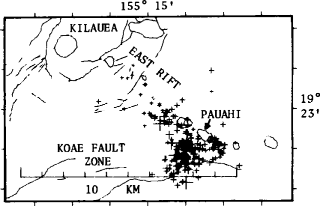 |
Figure 2. Plot of shallow earthquakes (1-5 km depth) associated with the 16-17 November 1979 eruption. |
"The swarm began at 2100 hours on 15 November near Pauahi Crater, 7-8 km SE of the central caldera region, and within a half an hour the summit tiltmeter indicated the onset of deflation (figure 3). Simultaneously, two borehole tiltmeters detected inflation in the upper part of the E rift zone (see table 3 a for detailed chronology). Shallow volcanic tremor very local to Pauahi Crater (figures 3 and 4) became strong at about 0700 the next morning (16 November) as the number of earthquakes gradually decreased. At 0821, low fountaining (less than 10 m high) started in Pauahi Crater. Fifteen minutes later, observers arrived on the E side of the crater and found a curtain of fire 5-10 m high and 100 m long. These E vents ceased eruption less than 1 hour later. At 1130, two more vents opened in Pauahi Crater, W of the first Pauahi vent. Shortly thereafter, brief fountaining was observed N of the earlier E vents, followed by cessation of activity of the initial (eastern) Pauahi Crater vent. Over the next 1.5 hours, six more vents opened progressively to the W, one more in the crater and five W of the crater. Slightly before 1600, activity at the W vents began to wane and over the next hour fountaining ceased progressively eastward at the five W vents. Lava production in the three remaining vents in Pauahi Crater stayed relatively constant until 0100 on 17 November, gradually waned, then ceased activity at 0630, 22 hours after the eruption began.
Table 3. Chronology of the November 1979 eruption at Kīlauea.
| Date | Time | Activity |
| 15 Nov 1979 | 2100 | Seismic swarm began local to Pauahi station. |
| 15 Nov 1979 | 2130 | Deflation at the summit and inflation at the eruption site. |
| 16 Nov 1979 | 0005 | Peak earthquake rate. |
| 16 Nov 1979 | 0700 | Strong tremor began local to Pauahi station. |
| 16 Nov 1979 | 0805 | Copious steam and fume emission began E of Pauahi Crater. The fissures occupied an old spatter rampart and never emitted lava, but the emitted gases were hot enough to ignite adjacent vegetation. |
| 16 Nov 1979 | 0821 | A sharp cracking sound accompanied the opening of a vent (P1, figure 4) on the NE wall of the NW lobe of Pauahi Crater; initial fountain heights were less than 1 m. |
| 16 Nov 1979 | 0836 | Observers arriving at Road's End parking lot found fissures already erupting a low (5-10 m) curtain of fire (E1, figure 4) about 100 m long, 230 m E of the copiously fuming area noted at 0805. Fissuring migrated E, eventually producing a separate lava pad (E2). New fissures east of the E2 vent occupied the center of an old spatter rampart. |
| 16 Nov 1979 | 0925 | Eruptive activity on E1 and E2 fissures ceased. |
| 16 Nov 1979 | 1130 | A fissure opened about 70 m W of the still active P1 vent in Pauahi Crater, and almost immediately began to fountain to heights of 2-10 m on its W end. A few seconds later, three smaller vents began activity between the new fountain (P2) and P1. These vents collectively are labeled P3. |
| 16 Nov 1979 | 1135 | Brief eruption (time uncertain) from a fissure (EN) N of the main E vents. |
| 16 Nov 1979 | 1140 | An eruptive fissure (P4) opened 20 m W of P2. |
| 16 Nov 1979 | 1149 | Activity at P1 vent abruptly decreased with concurrent increase of activity at P2, P3, P4. |
| 16 Nov 1979 | 1150 | P1 vent ceased activity. |
| 16 Nov 1979 | 1155-1200 | Flows produced by the now-inactive P1 began to cascade down the mezzanine into the SE crater of Pauahi, followed by flows from P2-4. |
| 16 Nov 1979 | 1203 | Fissures migrating W of Pauahi Crater cut the overlook parking lot and the Chain of Craters Road. |
| 16 Nov 1979 | 1214 | Eruption began from E to W on three fissures (W1, W2, and W3) beginning just W of the Chain of Craters Road; concurrently there was a temporary decrease in activity of vents P2-4 in Pauahi. Curtains of fire to 10 m high with spatter ejected to 30-40 m were soon established on two of the new vents (W2 and W3); weak spattering occurred at W1 vent. |
| 16 Nov 1979 | 1239 | Eruption began at W4 vent. Activity at W1, W2, and W3 vents decreased abruptly at the onset of this activity. |
| 16 Nov 1979 | 1255 | Eruption began from W5 vent, followed by roughly constant rates of effusion (about 50,000 m3/hour) from all the W vents over the next 3.5 hours. |
| 16 Nov 1979 | 1445 | Tremor amplitude at seismic stations 6 km from the eruption site reached a peak. The earthquake rate dropped by an order of magnitude from its peak values at 0005. |
| 16 Nov 1979 | 1542 | Abrupt brief decrease in fountain height of all W vents followed by cessation of activity at W5 vent and slight decrease in activity of vents P2-4. |
| 16 Nov 1979 | 1543-1631 | Decrease and cessation of activity of W4 vent. Decrease in activity of W2 and W3 vents; nature of activity at W1 vent unknown, but total emission from W1 was less than 15 m3. |
| 16 Nov 1979 | 1547-1555 | Chain of Craters road cut by small flow lobes. |
| 16 Nov 1979 | 1631-1648 | Activity of W2 and W3 vents declined to sporadic spatter emission. |
| 16 Nov 1979 | 1651 | Cessation of activity at all W vents. |
| 16 Nov 1979 | 1716 | Increase in activity of P2, P3, and P4 vents; approximately constant combined effusion rate of P2-4 of 15,000-20,000 m3/hour for the next 6 hours. |
| 16 Nov 1979 | 1845 | Activity of P4 vent decreased. |
| 16 Nov 1979 | 2030 | Activity of P4 vent essentially ceased. |
| 17 Nov 1979 | 0100-0409 | Activity at P2 and P3 continually waned. |
| 17 Nov 1979 | 0413 | Continued decrease in activity of P2 and P3 vents; tilt at summit reversed; seismic tremor subsided. |
| 17 Nov 1979 | 0630 | All but gas activity ceased in Pauahi crater vents. |
| 17 Nov 1979 | 0809 | Surface movement of red lava in channels in Pauahi ceased, followed over the next 2 hours by collapse of crust and levees and formation of slab pahoehoe. |
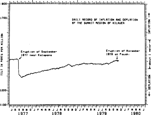 |
Figure 3. Daily record of summit inflation of Kīlauea, 1977-78. |
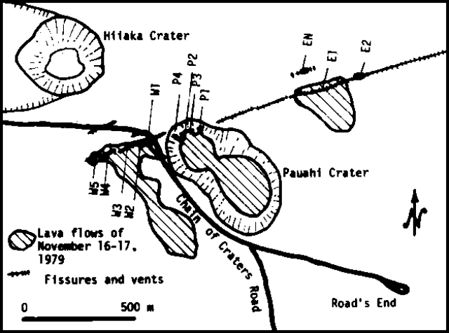 |
Figure 4. Preliminary sketch map of the 16-17 November 1979 eruption site. |
"During the eruption, tremor amplitude fluctuated with the extrusion rate, and earthquakes continued to decline to a frequency only slightly higher than a normal background rate. Earthquakes immediately preceding and accompanying the eruption occurred within a roughly triangular zone bounded by the E rift, Koae fault zone, and a N-S line 1 km W of Pauahi (figure 2).
"Unlike previous events, which presumably defined a downrift propagation of magma from the summit reservoir, epicenters during this eruption showed no downrift migration and tremor did not occur near stations uprift of the eruption. Furthermore, earthquakes migrated upward from 3 to 1 km in depth during the first 2 hours of the swarm. It therefore seems probable that the eruption was fed by magma already stored beneath the rift zone and that magma drained from the summit reservoir to replace the magma mobilized in the E rift zone near the eruption site.
"Figure 3, summarizing the pattern of inflation at the summit of Kīlauea between the 1977 and 1979 eruptions, shows that throughout the month of November 1978, there was a slow deflation of the summit. Concurrently, an area approximately centered on the 1977 eruption site started to inflate. Except for the minor deflation centers along the upper E rift zone, the upper and lower parts of the E rift zone remained relatively undeformed during the period between eruptions.
"Summit SO2 emission averaged 100-200 t/d over the 13 months preceding the eruption and peaked occasionally at 350 t/d. Ten days prior to the eruption a spike of 500 t/d was recorded, followed by a return to approximately normal daily emission throughout and following the eruption. Anomalous abundances of S were observed in condensates at two sites and of CO2 at one site. The data base is too short to determine whether the observed variations of S and CO2 are indicators of magmatic activity preceding the November eruption, or were coincident fluctuations unrelated to magma movement.
"The eruption was characterized by less than 700,000 m3 erupted volume, low fountains, generally low amounts of fume, viscous lava and spatter, and low temperatures (generally 1,040-1,080°C with an infrared pyrometer). The overall pattern of the fissure system suggests that a left lateral shear couple was present during the eruption. The only obvious phenocryst observed by preliminary megascopic observation is olivine, 0.5-2 mm in diameter. The earliest samples, especially those from the easternmost vents, appear to be poor in olivine (1-3%), whereas those from the later stages contain 3-8% olivine phenocrysts. Interpretations of this variation include: 1) eruption of a single fractionated magma body; 2) eruption of several discrete, compositionally variable, possibly fractionated magma bodies, and 3) an influx, during the later stages of the eruption, of more primitive (olivine-rich) magma that drained from the summit reservoirs.
"The seismology, petrology, and surface deformation suggest that the eruption was likely the result of a disturbance of a shallow local storage chamber where the magma had resided for several months or years. The immediate area had been the site of the August 1968, May 1973, and November 1973 eruptions and lies along the geologically and seismically defined shallow conduit system leading from the summit magma chamber.
"Summit deflation suggests that the volume of magma withdrawn from the summit reservoirs was 4-6 times that erupted. Presumably this excess magma is stored in conduits and reservoirs in the upper E rift zone. Figure 3 indicates that the November eruption involved a trivial amount of the magma that has been supplied to the summit since the September 1977 eruption, and at present, the level of summit inflation is approximately that prior to the eruption."
Geological Summary. Kilauea overlaps the E flank of the massive Mauna Loa shield volcano in the island of Hawaii. Eruptions are prominent in Polynesian legends; written documentation since 1820 records frequent summit and flank lava flow eruptions interspersed with periods of long-term lava lake activity at Halemaumau crater in the summit caldera until 1924. The 3 x 5 km caldera was formed in several stages about 1,500 years ago and during the 18th century; eruptions have also originated from the lengthy East and Southwest rift zones, which extend to the ocean in both directions. About 90% of the surface of the basaltic shield volcano is formed of lava flows less than about 1,100 years old; 70% of the surface is younger than 600 years. The long-term eruption from the East rift zone between 1983 and 2018 produced lava flows covering more than 100 km2, destroyed hundreds of houses, and added new coastline.
Information Contacts: N. Banks and F. Klein, HVO.