Report on Fukutoku-Oka-no-Ba (Japan) — November 1980
Scientific Event Alert Network Bulletin, vol. 5, no. 11 (November 1980)
Managing Editor: David Squires.
Fukutoku-Oka-no-Ba (Japan) Discolored water seen during April-July 1980
Please cite this report as:
Global Volcanism Program, 1980. Report on Fukutoku-Oka-no-Ba (Japan) (Squires, D., ed.). Scientific Event Alert Network Bulletin, 5:11. Smithsonian Institution. https://doi.org/10.5479/si.GVP.SEAN198011-284130
Fukutoku-Oka-no-Ba
Japan
24.285°N, 141.481°E; summit elev. -29 m
All times are local (unless otherwise noted)
The Japan Maritime Safety Agency (JMSA) continues frequent monitoring flights over several known submarine volcanoes. [Discolored water at Fukutoku-Okanoba was seen during April-July 1980 (see table 1 below).]
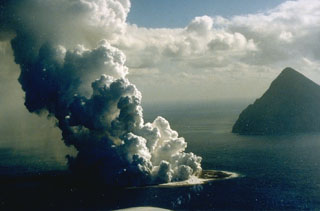
Geological Summary. Fukutoku-Oka-no-ba is a submarine volcano located 5 km NE of the island of Minami-Ioto. Water discoloration is frequently observed, and several ephemeral islands have formed in the 20th century. The first of these formed Shin-Ioto ("New Sulfur Island") in 1904, and the most recent island was formed in 1986. The volcano is part of an elongated edifice with two major topographic highs trending NNW-SSE, and is a trachyandesitic volcano geochemically similar to Ioto.
Information Contacts: JMSA, Tokyo; JMA, Tokyo.