Report on Kilauea (United States) — November 1983

Scientific Event Alert Network Bulletin, vol. 8, no. 11 (November 1983)
Managing Editor: Lindsay McClelland.
Kilauea (United States) 11th and 12 major phases of East Rift Zone eruption
Please cite this report as:
Global Volcanism Program, 1983. Report on Kilauea (United States) (McClelland, L., ed.). Scientific Event Alert Network Bulletin, 8:11. Smithsonian Institution. https://doi.org/10.5479/si.GVP.SEAN198311-332010
Kilauea
United States
19.421°N, 155.287°W; summit elev. 1222 m
All times are local (unless otherwise noted)
"The 11th and 12th eruptive episodes occurred on 6-7 November and 29 November-1 December. As in episodes 4-10, the growing spatter cone, Pu'u O, located just within Hawaii Volcanoes National Park, was the major eruptive locus.
EPISODE 11
"Unlike most of the previous eruptive episodes at Pu'u O, when vigorous lava production was preceded by several hours to several days of low-level activity within the crater, episode 11 began quickly. Harmonic tremor in the eruptive zone began to increase above normal repose-period background levels at 2314 on 5 November and reached a maximum amplitude at 0025 on 6 November. An electric trip wire, installed within the crater of Pu'u O to monitor the first appearance of lava, was broken between 2350 on 5 November, and 0000 on 6 November. By 0010, glow from the eruption was visible 20 km away at HVO. Between midnight and dawn on 6 November, low fountains were seen from Mountain View, 18 km to the N and from Kalapana, on the coast 14 km to the SE.
"When the first observers arrived at 0730, discontinuous low fountains played along a 700-m line approximately centered on Pu'u O. All of the fountains were relatively low. Those NE and SW of Pu'u O were about 10-20 m high. The most voluminous fountains rose about 40 m from the surface of a pond within the crater at Pu'u O; throughout the eruption they were barely visible above the 80 m-high crater rim.
"Pu'u O was the major locus of lava production. As in episodes 6-10, its lava pond overflowed through a breach in the NE crater wall, forming a vigorous lava river that eventually extended about 6 km before turning from pahoehoe to aa. By the end of episode 11, the river had fed a 9.5 km-long aa flow, the longest in the 1983 eruption, that advanced NE on top of earlier flows from Pu'u O, then extended an additional 4 km through dense rain forest. Vents 100-200 m SW of Pu'u O, in combination with a vent high on the W flank of the cone, produced pahoehoe flows that spread an estimated 1.2 x 10⁶ m3 of new basalt W and S of Pu'u O until the early morning of 7 November, when the W vents stopped erupting.
"During the 43 hours of eruption, approximately 12.1 x 10⁶ m3 of lava was extruded, 85% in the long flow to the NE. In hand-lens view, the basalt is sparsely porphyritic with scattered olivine phenocrysts up to about 2 mm in diameter. Lava temperatures, measured by thermocouple in pahoehoe toes in flows from the W vents and in sustained overflows from the lava river, ranged from 1,141 to 1,144°C. Lower temperatures, 1,133-1,135°C, were measured at the river's edge.
"Harmonic tremor amplitude, sustained during the eruption at a level comparable to that of recent previous episodes, dropped rapidly between 1840 and 1850 on 7 November, at the end of the eruption.
"Summit subsidence began at about 0200 on 6 November, approximately 2 hours after the onset of eruption, and continued until about half an hour after the eruption's end on 7 November. The deflationary tilt change of about 19 µrad at Uwekahuna corresponds with a summit volume loss of about 8 x 10⁶ m3.
16 November earthquake - repose period activity. "At 061301 on 16 November, a magnitude 6.7 earthquake occurred in the Kaoiki region (figure 22) between Mauna Loa and Kīlauea, an area of persistently high seismicity. Several tens of earthquakes are commonly recorded daily by nearby seismic stations of HVO's 48-station island-wide network. Over the past 3 decades, about 35 earthquakes of magnitude >= 4 have occurred in the Kaoiki region, two of the largest on 27 June 1962 (M 6.1), and on 30 November 1974 (M 5.5). The 16 November 1983 earthquake was highest in magnitude, ground breakage, and structural damage. Ground breakage related to shaking and gravitational adjustments on 16 November occurred along Kaoiki fault scarps and along Kīlauea caldera faults. Landslides and rockfalls occurred on the steep caldera and crater walls, and on the (Hilina) escarpments on Kīlauea's S flank. A 4.7 km-long zone of E-W-trending tension fissures has been identified as the possible main surface rupture. A N50°E line from the epicenter of the main shock intersects the fissure zone 5 km to the N. The fissure zone, approximately 50-100 m wide, is recognized as a series of en echelon offsets to the left. Thus far, 15-20 cm of southward extension has been measured on some E-W-trending extension cracks.
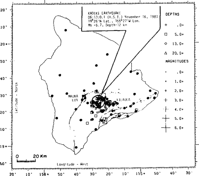 |
Figure 22. Location of the M 6.7 Kaoiki earthquake and the initial 10 hours of aftershocks. Local seismic data indicate strike-slip faulting with an E-W orientation of the pressure axis, and a N-S orientation of the tension axis. Darkened circles represent seismic stations that continuously telemeter signals to HVO. |
"The earthquake was 12 km deep, and a preliminary first motion analysis from local seismic data indicates a strike-slip mechanism. The faulting was a probable result of compressional stresses within the crust induced by magmatic activity generating lateral tensions from Mauna Loa and Kīlauea. The NE-trending nodal plane with a right lateral strike-slip motion is preferred on the basis of aftershock distribution of past events.
"In 8 days following the main shock, more than 9,000 earthquakes have been detected on stations a few kilometers from the aftershock zone. Over 800 of these, ranging in magnitude from about 1.0-4.3, were selected for processing by computer for location and magnitude. About 50 aftershocks were greater than magnitude 3.0, and 3 were over magnitude 4.0. Preliminary determinations of hypocenters during the initial 10 hours of aftershock activity indicate an epicentral zone about 20 km in diameter centered between the summit areas of Mauna Loa and Kīlauea. Focal depths are concentrated at about 10 km.
"Between episodes 11 and 12, low-level harmonic tremor typical of repose periods persisted in the eruption zone. Copious hot oxidized fume issued continuously from Pu'u O, maintaining incandescence in numerous openings. Neither the tremor nor the fume production changed recognizably in response to the 16 November earthquake. The earthquake, however, produced a major perturbation in the record of Kīlauea summit tilt (figure 23).
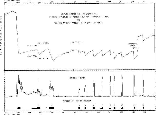 |
Figure 23. Kīlauea summit tilt, periods of lava production, and amplitude of harmonic tremor for phases 1-12. |
EPISODE 12
"Episode 12 began in earnest at 0447 on 30 November, and continued until 1545 on 1 December. Lava flows to the N, NE, and E originated from Pu'u O, where low fountains played on the S and N rims of the cone and within the breach on its NE flank. The main flow issued through the NE breach, which has been the principal spillway since late July. Advancing 8 km during the eruption, the front covered 1977 lavas S of the main episode 11 flow. Less voluminous flows issued from the S part of the vent and advanced about half the distance to the Royal Gardens subdivision.
"Lava apparently first reached the surface within the crater of Pu'u O at 1600 on 29 November, when an electric trip wire within the crater was cut. Faint glow in the eruptive zone was first reported at 2300. Intermittent low-level tremor near Pu'u O started to increase gradually at about that time (2300). The increase accelerated in the next few hours, and at 0447 on 30 November, a sharp increase was recorded, apparently marking the start of major lava emission. Visible fountains and audible roar from the vent were first reported at about 0450. Tremor peaked between 0530 and 0730 on 30 November with an amplitude more than an order of magnitude above background level. Tremor started to decrease rapidly at about 1545 on 1 December, marking the end of the eruptive episode. As of 5 December, the level of harmonic tremor in the E rift zone was very low but frequent microearthquakes were associated with near-surface activity at the vent."
Geological Summary. Kilauea overlaps the E flank of the massive Mauna Loa shield volcano in the island of Hawaii. Eruptions are prominent in Polynesian legends; written documentation since 1820 records frequent summit and flank lava flow eruptions interspersed with periods of long-term lava lake activity at Halemaumau crater in the summit caldera until 1924. The 3 x 5 km caldera was formed in several stages about 1,500 years ago and during the 18th century; eruptions have also originated from the lengthy East and Southwest rift zones, which extend to the ocean in both directions. About 90% of the surface of the basaltic shield volcano is formed of lava flows less than about 1,100 years old; 70% of the surface is younger than 600 years. The long-term eruption from the East rift zone between 1983 and 2018 produced lava flows covering more than 100 km2, destroyed hundreds of houses, and added new coastline.
Information Contacts: E. Wolfe, A. Okamura, and R. Koyanagi, HVO.