Report on Kilauea (United States) — January 1984

Scientific Event Alert Network Bulletin, vol. 9, no. 1 (January 1984)
Managing Editor: Lindsay McClelland.
Kilauea (United States) 13th-15th major episodes of East Rift Zone eruption include lava fountains to 300 m and temperatures to 1,147°C
Please cite this report as:
Global Volcanism Program, 1984. Report on Kilauea (United States) (McClelland, L., ed.). Scientific Event Alert Network Bulletin, 9:1. Smithsonian Institution. https://doi.org/10.5479/si.GVP.SEAN198401-332010
Kilauea
United States
19.421°N, 155.287°W; summit elev. 1222 m
All times are local (unless otherwise noted)
"Kīlauea's episodic E rift zone eruption resumed in late January after 7 weeks of repose characterized by a desultory pattern of summit inflation, vanishingly weak harmonic tremor, and the virtual disappearance of magmatic gas at the vent. Episode 13 occurred 20-22 January, and episode 14 on 30-31 January. As in episodes 4-12, the eruptive vent for episodes 13 and 14 was at Pu'u O (figure 24).
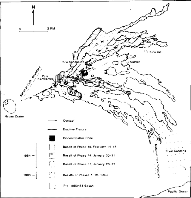 |
Figure 24. Kīlauea lava flows from episodes 13, 14, and 15. Courtesy of HVO. |
EPISODE 13
"Episode 12, which ended on 1 December 1983, left a complex of craters separated by low septa in the interior of Pu'u O. The largest and most central of the craters narrowed downward into a nearly vertical pipe about 20 m in diameter and at least 90 m long.
"On 20 January, harmonic tremor in the eruption zone increased gradually beginning at about 1030, and at 1117 HVO personnel first sighted moving lava about 50 m down in the pipe; by mid-afternoon the lava column could be seen slowly rising within the pipe. At 1724, the lava, which had by then filled the pipe and spread across the 30-40 m-wide floor of the crater, began to flow through the deep breach in the crater's NE rim. Supplied at a rate of approximately 10,000 m3/hour (an order of magnitude less than normal minimum rates for vigorous eruption at Pu'u O), the lava began advancing NE in the channel evacuated at the end of episode 12. By this time, tremor amplitude had increased tenfold.
"As the lava rising within Pu'u O approached and overflowed the spillway, the lava surface, from which a low dome fountain repeatedly rose and fell, was agitated, resembling a rolling boil in a saucepan. Over the next few hours, the vigor of lava emission and fountain activity gradually increased, accompanied by increasingly intense harmonic tremor.
"Unlike some of the recent previous episodes, in which a complex of fountains formed within Pu'u O as well as on its rim and flanks, episode 13 developed a single fountain over the large central conduit. The production of lava, normally steady in previous episodes, pulsed strongly. At intervals on the order of 0.5-1 minute the flux of lava in the channel and the height of the fountain waxed and waned. Hence, the fountain alternated rapidly from about the height of the crater rim (30-40 m above the pond surface within the crater) to as much as 40 or 50 m above the crater rim. The repeated increases in discharge of lava caused surges that advanced at about 10 m/s down the first 100 m or so of the lava channel.
"Episode 13 effusion stopped temporarily on 22 January at about 0030. During this first 31-hour period the lava river debouching from Pu'u O fed a 7 km-long flow that advanced NE. It split into 2 lobes (at Pu'u Kahauale'a) that rejoined farther NE. Continuous eruptive activity resumed at about 0530; it was preceded by an hour of intermittent, low fountain activity. The fountain was visible above the rim of Pu'u O by 0550, and effusion accompanied by renewed intense harmonic tremor continued until the eruptive activity waned sporadically from 1115 to its termination at 1123. This 6-hour period produced a second flow that advanced directly on top of the first; it followed the fork N of Pu'u Kahauale'a and stopped about 3 km NE of Pu'u O. The two effusive periods each terminated with [discontinuous] lava emission such that the fountain disappeared and reappeared repeatedly for a period of several minutes. Simultaneously, harmonic tremor decayed with marked alternations in amplitude.
Repose-period activity. "After episode 13, the interior of Pu'u O was a single bowl-like crater with a narrowing conduit, about 25 m wide at its mouth, extending downward from the crater floor. Throughout the entire repose period between episodes 13 and 14, the surface of a lava column was visible at depths of 0-25 m in the conduit. Sometimes fresh to barely crusted lava was exposed at the pond surface; at other times the pond surface was a solid frozen crust through which a small (0.5-3 m) orifice accommodated intermittent venting of magmatic gas, spatter, and small flows. At times, emission of spatter and gas through the small vent in the crust or alternating rise and fall of the fluid pond surface through a vertical interval of 10-15 m became strongly rhythmic with cycles about 4-6 minutes long. The activity closely resembled the gas-piston activity noted in Mauna Ulu lava ponds (1969-1974). In a typical cycle at Pu'u O, the pond surface appeared deep in the conduit and slowly rose for about 4 minutes. It remained poised momentarily, became agitated, and the lava then drained rapidly out of sight in about 1/2 minute. Draining was accompanied by emission of a plume of magmatic gas and a brief increase in tremor amplitude. After 1.5 minutes, lava would reappear deep in the conduit. When last visited in the early afternoon of 30 January, the lava pond had filled the steep-walled conduit and had begun to spread across the more gently sloping floor of the crater. About 30 m in diameter, the pond surface was about 5 m below the low point in the breach of the crater's NE rim. The surface was solid, and gas under pressure along with minor spatter issued intermittently with a deafening roar from a 0.5 m-diameter vent in the crust. Gas samples from this vent showed that there had been no change in gas composition during more than a year of eruptive activity.
EPISODE 14
"At about 1030 on 30 January, the amplitude of harmonic tremor began a gradual and persistent increase that reached a high level by about 1830, when glow and visible fountains of episode 14 were first reported. Observations from a vantage point in the upper E rift zone as well as from the S coast of Kīlauea indicate that in the evening hours the sustained height of the fountain at Pu'u O was 150-200 m above the rim of the cone, and bursts of spatter were rising as high as 300 m. By morning, when observers arrived at the vent, the single fountain, again centered over the large central conduit, was lower; through the remainder of episode 14 the fountain height fluctuated at intervals of 10-20 seconds from low (commonly 10-20 m above the rim of the cone) to high levels (up to about 80-100 m above the rim of the cone). The high bursts produced tephra plumes and short-lived spatter-fed flows on the flanks of Pu'u O.
"Flows to the N and E (figure 24) were fed by distributary channels branching from the lava river that poured through the breached NE crater rim. The longest flow extended about 4 km from the vent. It turned SE and extended about halfway to Royal Gardens subdivision. A thick aa flow, fed entirely by spatter that cascaded over the S rim of the cone, advanced about 1.5 km S.
"Between 1315 and 1318 on 31 January lava emission declined, once again in spasmodic fits and starts. Harmonic tremor also decreased rapidly beginning at 1315, marking the eruption's end. In early February, the level of tremor, like that between episodes 13 and 14, was considerably higher than the background level during many of the previous repose periods.
"Following episode 14, the crater of Pu'u O was again a broad, steep-walled bowl from which a 20 m-diameter conduit extended nearly vertically downward. A 30-40 m-deep cleft in the NE crater rim marked the breach through which lava exited the crater.
Petrology. "Basalt of episodes 13 and 14 is sparsely porphyritic with scattered small olivine phenocrysts visible in hand-lens view. Lava temperatures measured by thermocouple were 1,129-1,131°C in the first few hours of episode 13. Subsequent episode 13 temperatures were 1,140-1,147°C, and include the highest temperature measured so far in this series of eruptions. During episode 14, temperatures, measured only at the edges of the widespread pahoehoe flow N of Pu'u O, were 1,136-1,137°C.
Deformation. Rapid summit subsidence, as recorded by the Uwekahuna tiltmeter, began at 2100 on 20 January and again at 1930 on 30 January-in each case a short time after vigorous eruption was under way. Resumption of inflationary tilt followed the end of each eruption by several hours. E-W deflationary changes measured at Uwekahuna were 11 µrad for episode 13 and 10 µrad for episode 14. This suggests that a minimum of 8 x 10⁶ m3 of magma was withdrawn from the summit reservoir system during episodes 13 and 14."
Addendum: Episode 15 began at about 1945 on 14 February with a sharp increase in harmonic tremor. Summit deflation began about 2 hours later. During the evening, lava fountains rose as high as 300 m from the previously active vent at Pu'u O. Vigorous lava fountaining continued the next morning and lava flowed E and NE from Pu'u O. Eruptive activity ceased at about 1500 on 15 February.
Geological Summary. Kilauea overlaps the E flank of the massive Mauna Loa shield volcano in the island of Hawaii. Eruptions are prominent in Polynesian legends; written documentation since 1820 records frequent summit and flank lava flow eruptions interspersed with periods of long-term lava lake activity at Halemaumau crater in the summit caldera until 1924. The 3 x 5 km caldera was formed in several stages about 1,500 years ago and during the 18th century; eruptions have also originated from the lengthy East and Southwest rift zones, which extend to the ocean in both directions. About 90% of the surface of the basaltic shield volcano is formed of lava flows less than about 1,100 years old; 70% of the surface is younger than 600 years. The long-term eruption from the East rift zone between 1983 and 2018 produced lava flows covering more than 100 km2, destroyed hundreds of houses, and added new coastline.
Information Contacts: E. Wolfe, A. Okamura, R. Koyanagi, T. Duggan, R. Okamura, HVO.