Report on Kilauea (United States) — July 1984

Scientific Event Alert Network Bulletin, vol. 9, no. 7 (July 1984)
Managing Editor: Lindsay McClelland.
Kilauea (United States) Episodes 22-23 of 1983-84 E Rift Zone eruption
Please cite this report as:
Global Volcanism Program, 1984. Report on Kilauea (United States) (McClelland, L., ed.). Scientific Event Alert Network Bulletin, 9:7. Smithsonian Institution. https://doi.org/10.5479/si.GVP.SEAN198407-332010
Kilauea
United States
19.421°N, 155.287°W; summit elev. 1222 m
All times are local (unless otherwise noted)
"Two eruptive episodes occurred on the E rift zone in July. Episode 22 began about 1930 on 8 July, stopped abruptly at 1017 on the 9th, and produced approximately 7.7 x 10⁶ m3 of basalt (figure 28).
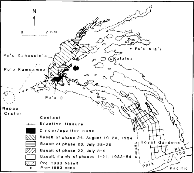 |
Figure 28. Lava flows erupted at Kīlauea between 3 January 1983 and 20 August 1984. Flows from episodes 22-24 are shown separately. Courtesy of HVO. |
EPISODE 23
"Episode 23 began at about noon on 28 July and lasted until about 0540 on the 29th (mapping in progress). Pu'u O (Enduring Hill in Hawaiian) was again the vent for lavas that flowed about 5 km to the NE, down the NW side of the rift zone (mostly outside the National Park). Both episodes were characterized by high fountain activity, short spatter-fed aa flows, and thin tephra blankets near the cone. The crater at Pu'u O has filled with solid basalt to near the level of the spillway that, following episode 23, was located on the N side of the cone and about 50 m below the highest point on the crater rim (on its SW side). More detailed surveying since June placed the summit elevation at 145 m above the pre-1983 surface and 80-100 m above surrounding accumulations of new basalt. The average diameter of the base of the cone was about 550 m. The basalt produced continued to be nearly aphyric with widely scattered phenocrysts of small (< 1 mm) olivine.
Deformation. "During the 8-day period after episode 21 (30 June), the E-W summit tilt (at Uwekahuna) increased at a rate of less than one µrad per day. At 1200 on 8 July, the tilt started downward, indicating summit subsidence; eruptive activity at Pu'u O began 6 hours later. The maximum rate of summit subsidence (1 µrad per hour) occurred 1.5 hours after the onset of episode 22. Summit subsidence continued until 1600 on 9 July, 6 hours after lava production had ceased. The total E-W tilt change recorded was 13 µrad. Rapid inflationary tilt change during the two days following episode 22 totaled 5 µrad.
"Between 13 and 28 July, a slower rate of summit uplift was reflected in the net upward tilt change of 7 µrad. The amount of summit subsidence that occurred during episode 23 (28-29 July) corresponded to a downward tilt change of 13 µrad. At the end of July, Kīlauea's summit was reinflating.
"The summit has undergone a net vertical subsidence of 50 mm since January 1984. Cross-rift deformation lines have been established 0.7 and 9 km uprift of Pu'u O. An additional telemetering tiltmeter has been installed about 7 km uprift of the 1983-84 eruption site.
Seismicity. "Harmonic tremor at the Kamoamoa seismic station was continuous and centered near Pu'u O. Tremor amplitudes were characteristically high during periods of vigorous lava output and low between the eruptive episodes. High tremor accompanying episode 22 started at 1859 on 8 July and ended at 1017 the next day.
"Tremor began to increase for episode 23 at 1158 on 28 July and declined at 0543 the next day. Associated with the accelerated summit deflation and toward the end of the eruptive episodes, a secondary source of intermediate-amplitude tremor in the shallow summit region was detected. Low interphase tremor near Pu'u O varied from cyclic bursts at about 10-minute intervals to signals of uniform amplitude lasting up to several days."
Geological Summary. Kilauea overlaps the E flank of the massive Mauna Loa shield volcano in the island of Hawaii. Eruptions are prominent in Polynesian legends; written documentation since 1820 records frequent summit and flank lava flow eruptions interspersed with periods of long-term lava lake activity at Halemaumau crater in the summit caldera until 1924. The 3 x 5 km caldera was formed in several stages about 1,500 years ago and during the 18th century; eruptions have also originated from the lengthy East and Southwest rift zones, which extend to the ocean in both directions. About 90% of the surface of the basaltic shield volcano is formed of lava flows less than about 1,100 years old; 70% of the surface is younger than 600 years. The long-term eruption from the East rift zone between 1983 and 2018 produced lava flows covering more than 100 km2, destroyed hundreds of houses, and added new coastline.
Information Contacts: G. Ulrich, A. Okamura, and R. Koyanagi, HVO.