Report on Kilauea (United States) — October 1986

Scientific Event Alert Network Bulletin, vol. 11, no. 10 (October 1986)
Managing Editor: Lindsay McClelland.
Kilauea (United States) Continued lava production builds shield; flows burn forest
Please cite this report as:
Global Volcanism Program, 1986. Report on Kilauea (United States) (McClelland, L., ed.). Scientific Event Alert Network Bulletin, 11:10. Smithsonian Institution. https://doi.org/10.5479/si.GVP.SEAN198610-332010
Kilauea
United States
19.421°N, 155.287°W; summit elev. 1222 m
All times are local (unless otherwise noted)
The eruptive episode . . . was continuing in mid-November. The lava shield around the vent grew 2 m in height in October, to 46 m, but had not changed significantly in diameter despite occasional spillovers from the active lava pond. The level of the pond varied from 5 m below the rim to overflowing. Most flows were tube-fed to the SE. As of 3 November the longest was 6.8 km from the vent and had reached 290 m elevation, ~3.8 km from Chain of Craters Road (figure 47). The lava production was ~500,000 m3/day.
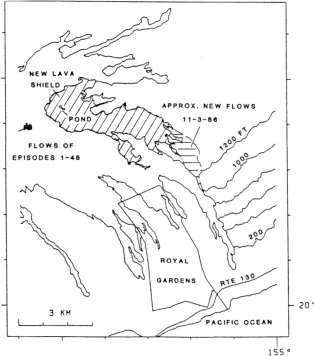 |
Figure 47. Map showing flows 20 July-3 February (diagonal lines), the new cracks and flow of 2 February, and the 1984 aa flow. |
The flows have not threatened inhabited areas, but large areas of forest have burned in the Kapaahu and Kaunaloa districts. Some residents with respiratory problems have left the Royal Gardens subdivision, especially at night when the wind direction commonly changes, bringing heavy smoke from burning vegetation upslope of the houses.
Summit tilt showed minor fluctuations (figure 45) but no significant trend of inflation or deflation. Harmonic tremor in the middle East rift zone continued at low levels with sporadic variations in amplitude
Geological Summary. Kilauea overlaps the E flank of the massive Mauna Loa shield volcano in the island of Hawaii. Eruptions are prominent in Polynesian legends; written documentation since 1820 records frequent summit and flank lava flow eruptions interspersed with periods of long-term lava lake activity at Halemaumau crater in the summit caldera until 1924. The 3 x 5 km caldera was formed in several stages about 1,500 years ago and during the 18th century; eruptions have also originated from the lengthy East and Southwest rift zones, which extend to the ocean in both directions. About 90% of the surface of the basaltic shield volcano is formed of lava flows less than about 1,100 years old; 70% of the surface is younger than 600 years. The long-term eruption from the East rift zone between 1983 and 2018 produced lava flows covering more than 100 km2, destroyed hundreds of houses, and added new coastline.
Information Contacts: C. Heliker, HVO.