Report on Kilauea (United States) — October 1987

Scientific Event Alert Network Bulletin, vol. 12, no. 10 (October 1987)
Managing Editor: Lindsay McClelland.
Kilauea (United States) Lava flows into ocean
Please cite this report as:
Global Volcanism Program, 1987. Report on Kilauea (United States) (McClelland, L., ed.). Scientific Event Alert Network Bulletin, 12:10. Smithsonian Institution. https://doi.org/10.5479/si.GVP.SEAN198710-332010
Kilauea
United States
19.421°N, 155.287°W; summit elev. 1222 m
All times are local (unless otherwise noted)
Activity . . . continued through October with three flows moving toward the coast. The westernmost lobe, up to 5 m thick in places, broadened but mostly stayed on top of September flows. The flow intermittently entered Royal Gardens subdivision, and the footpath from the road into the housing area was covered in late October, leaving the few remaining residents with no way of reaching their homes. The middle lobe was entering the ocean inside the national park. The new ocean front was ~700 m wide W of Kupapau point, moving W along the seacliffs toward the national park visitor center (at Wahaula; figure 53). The E lobe has completely buried the 1984 aa flow, and was intermittently entering the ocean 600 m E of Kupapau point along a front ~50 m wide. The level of the lava pond . . . was fairly constant, from nearly full to 6 m below the rim. There have been no overflows from the pond and all lava production has been carried away in the tube system.
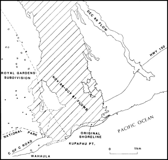 |
Figure 53. Sketch map of part of the SE coast of Hawaii with flows from the new eruptive vent in the lava shield, November 1986-January 1988. The dotted line shows the location of the new shoreline. |
Harmonic tremor continued at low and constant amplitude . . . . The number of shallow microearthquakes was about average in the summit region and East rift zone. Most of the earthquakes . . . in October were centered along the S flank of Kīlauea and SE flank of Mauna Loa at intermediate depths of 5-10 km. Twelve events with preliminary magnitudes of 2.5-4.1 were the strongest during the month.
Geological Summary. Kilauea overlaps the E flank of the massive Mauna Loa shield volcano in the island of Hawaii. Eruptions are prominent in Polynesian legends; written documentation since 1820 records frequent summit and flank lava flow eruptions interspersed with periods of long-term lava lake activity at Halemaumau crater in the summit caldera until 1924. The 3 x 5 km caldera was formed in several stages about 1,500 years ago and during the 18th century; eruptions have also originated from the lengthy East and Southwest rift zones, which extend to the ocean in both directions. About 90% of the surface of the basaltic shield volcano is formed of lava flows less than about 1,100 years old; 70% of the surface is younger than 600 years. The long-term eruption from the East rift zone between 1983 and 2018 produced lava flows covering more than 100 km2, destroyed hundreds of houses, and added new coastline.
Information Contacts: C. Heliker and R. Koyanagi, HVO.