Report on Taal (Philippines) — August 1988
Scientific Event Alert Network Bulletin, vol. 13, no. 8 (August 1988)
Managing Editor: Lindsay McClelland.
Taal (Philippines) Seismicity and slight inflation
Please cite this report as:
Global Volcanism Program, 1988. Report on Taal (Philippines) (McClelland, L., ed.). Scientific Event Alert Network Bulletin, 13:8. Smithsonian Institution. https://doi.org/10.5479/si.GVP.SEAN198808-273070
Taal
Philippines
14.0106°N, 120.9975°E; summit elev. 311 m
All times are local (unless otherwise noted)
During a two-week period in mid-August, several small, high-frequency events with average maximum double amplitudes of 2 mm were detected at the Pira-Piraso seismograph station. From 16-22 August, 11 high-frequency events were recorded. Slight inflation was detected by the water tube tiltmeter at the station. Weak steaming continued at the 1965 eruption site. Ground-probe hole temperatures were within normal limits and the lake level remained unchanged.
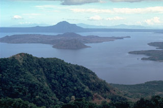
Geological Summary. Taal is one of the most active volcanoes in the Philippines and has produced some powerful eruptions. The 15 x 20 km Talisay (Taal) caldera is largely filled by Lake Taal, whose 267 km2 surface lies only 3 m above sea level. The maximum depth of the lake is 160 m, with several submerged eruptive centers. The 5-km-wide Volcano Island in north-central Lake Taal is the location of all observed eruptions. The island is composed of coalescing small stratovolcanoes, tuff rings, and scoria cones. Powerful pyroclastic flows and surges have caused many fatalities.
Information Contacts: PHIVOLCS.

