Report on Nevado del Tolima (Colombia) — October 1988
Scientific Event Alert Network Bulletin, vol. 13, no. 10 (October 1988)
Managing Editor: Lindsay McClelland.
Nevado del Tolima (Colombia) Occasional seismicity; minor fumarolic activity
Please cite this report as:
Global Volcanism Program, 1988. Report on Nevado del Tolima (Colombia) (McClelland, L., ed.). Scientific Event Alert Network Bulletin, 13:10. Smithsonian Institution. https://doi.org/10.5479/si.GVP.SEAN198810-351030
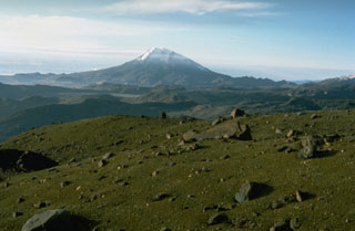
Nevado del Tolima
Colombia
4.658°N, 75.33°W; summit elev. 5215 m
All times are local (unless otherwise noted)
Seismicity at Tolima was recorded in December 1987 and September-October 1988 by a telemetric station 2 km SE of the summit (figure 1). During October, as many as seven high-frequency events/day were recorded and minor fumarolic activity was observed. A 50-m-thick ice cap with an area of ~2 km2 covers the summit.
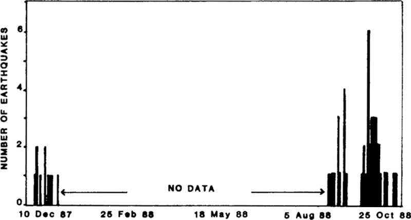 |
Figure 1. Number of earthquakes/day recorded by a seismic station 2 km SE of the summit, December 1987-October 1988. Courtesy of the Observatorio Vulcanológico de Colombia. |
Geological Summary. The steep-sided, glacier-covered Nevado del Tolima volcano contrasts with the broad profile of Nevado del Ruiz to the north. The andesitic-dacitic younger Tolima formed during the past 40,000 years, rising above and largely obscuring a 3-km-wide late-Pleistocene caldera. The summit consists of a cluster of late-Pleistocene to Holocene lava domes associated with thick block-lava flows on the N and E flanks, and extensive pyroclastic-flow deposits. The summit contains a funnel-shaped crater 200-300 m deep. Holocene activity has included explosive eruptions ranging in size from moderate to Plinian, and the last major eruption took place about 3,600 years ago. Lava dome growth has produced block-and-ash flows that traveled primarily to the NE and SE. Minor explosive eruptions have been recorded in the 19th and 20th centuries.
Information Contacts: C. Carvajal and F. Muñoz, INGEOMINAS, Manizales.