Report on St. Helens (United States) — October 1989

Scientific Event Alert Network Bulletin, vol. 14, no. 10 (October 1989)
Managing Editor: Lindsay McClelland.
St. Helens (United States) Earthquakes in magma conduit
Please cite this report as:
Global Volcanism Program, 1989. Report on St. Helens (United States) (McClelland, L., ed.). Scientific Event Alert Network Bulletin, 14:10. Smithsonian Institution. https://doi.org/10.5479/si.GVP.SEAN198910-321050
St. Helens
United States
46.2°N, 122.18°W; summit elev. 2549 m
All times are local (unless otherwise noted)
A marked increase in local seismicity began 19 October and continued for ~10 days. The number of locatable events detected by CVO's PC seismic acquisition system averaged only ~0.7/day through 18 October, then rose to 7/day through the end of the month; 11 shocks were recorded on the most active day, the 29th (figure 39). All of the events were small; the strongest, on 11 October at 0448 and 29 October at 0253, had coda magnitudes of 1.6 and 1.5 respectively. Epicenters were generally in the summit area (figure 40), with focal depths ranging from 1.6 to 11 km (figure 41), involving the entire magma conduit. The earthquakes were similar to A-type events, with well-defined S phases, in contrast to the August seismicity (SEAN 14:08), which was characterized by multiple monochromatic events without S phases. Seismicity declined at the end of October, and remained quiet as of mid-November. No associated changes in surface activity or deformation were detected.
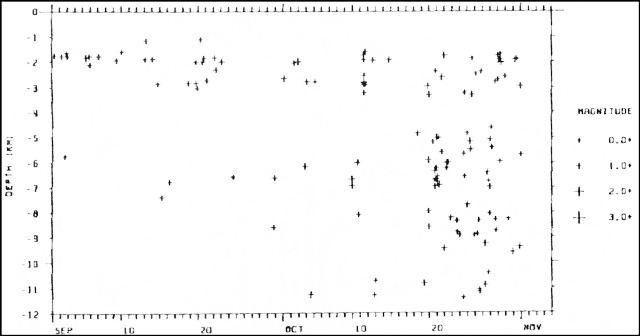 |
Figure 39. Space-time plot of foci for earthquakes ("A" and "B" quality) at Mt. St. Helens recorded by CVO's PC seismic data acquisition system, 1 September-31 October 1989. Courtesy of E. Endo. |
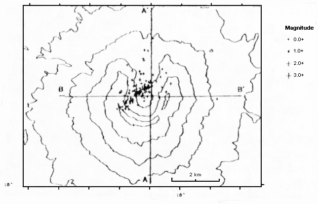 |
Figure 40. Epicenters of earthquakes at Mt. St. Helens detected by the USGS, 1 September-31 October 1989. Courtesy of E. Endo. |
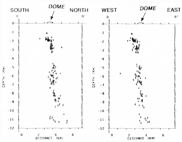 |
Figure 41. N-S and E-W cross-sections of earthquake hypocenters at Mt. St. Helens, 1 September-31 October 1989. Courtesy of E. Endo. |
Similar episodes of increased seismicity have been recorded at least eight times since late 1987. Most have lasted a few days to about a week and have included up to a few dozen small shocks, some of which were usually as deep as 10-12 km. The October activity was the longest and included the largest number of events of the post-1987 seismic episodes.
Geological Summary. Prior to 1980, Mount St. Helens was a conical volcano sometimes known as the Fujisan of America. During the 1980 eruption the upper 400 m of the summit was removed by slope failure, leaving a 2 x 3.5 km breached crater now partially filled by a lava dome. There have been nine major eruptive periods beginning about 40-50,000 years ago, and it has been the most active volcano in the Cascade Range during the Holocene. Prior to 2,200 years ago, tephra, lava domes, and pyroclastic flows were erupted, forming the older edifice, but few lava flows extended beyond the base of the volcano. The modern edifice consists of basaltic as well as andesitic and dacitic products from summit and flank vents. Eruptions in the 19th century originated from the Goat Rocks area on the N flank, and were witnessed by early settlers.
Information Contacts: E. Endo, CVO; Stephen Malone, Geophysics Program, University of Washington, Seattle, Washington 98195 USA.