Report on Manda Hararo (Ethiopia) — 15 August-21 August 2007
Smithsonian Institution / US Geological Survey
Weekly Volcanic Activity Report, 15 August-21 August 2007
Managing Editor: Sally Sennert.
Please cite this report as:
Global Volcanism Program, 2007. Report on Manda Hararo (Ethiopia) (Sennert, S, ed.). Weekly Volcanic Activity Report, 15 August-21 August 2007. Smithsonian Institution and US Geological Survey.
Manda Hararo
Ethiopia
12.17°N, 40.82°E; summit elev. 600 m
All times are local (unless otherwise noted)
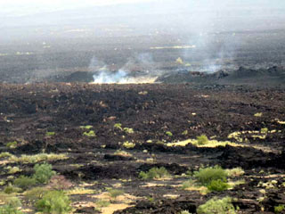
A large sulfur dioxide plume and several thermal anomalies from Manda Hararo were detected in satellite imagery on 13 August. On 16 August, a field team conducted aerial and ground observations of a locality known as Karbahi, a graben area with numerous active faults, fissures, and basalt flows, NW of the center of Manda Hararo. Observations revealed active volcanism, including isolated areas of intense gas emission and visible sulfur deposits. Basaltic lava flowed from long fissures, predominantly to the W of the graben floor. Each fissure was covered by a continuous row of small and closely spaced spatter and scoria cones 2-10 m high. Spatter and scoria deposits ranged in size from coarse lapilli to bombs. Incandescence and occasionally small flames were emitted from the tops of some of the cones.
Observed 'a'a and pahoehoe flows traveled a few hundred meters from the vents. The overall thickness of the flows varied but reached several meters in places. Lava channels and lava tubes were abundant. Fault scarps with fresh breaks and rockfalls were noted. The area affected by tectonic and volcanic activity was an estimated 5-7 km long and 1 km wide.
According to eye-witness accounts, a cracking sound was heard and a tremor was felt on 12 August. On 13 August, "fire" was seen that lit up a large area. "Fire and smoke" continued with variable intensity until 16 August. No damage to life or property was reported.
Geological Summary. As the southernmost axial range of western Afar, the Manda Hararo complex is located in the Kalo plain, SSE of Dabbahu volcano. The massive 105-km-long and 20-30 km wide complex represents an uplifted segment of a mid-ocean ridge spreading center. A small basaltic shield volcano is located at the N end of the complex, S of which is an area of abundant fissure-fed lava flows. Two basaltic shield volcanoes, the larger of which is Unda Hararo, occupy the center of the complex. The dominant Gumatmali-Gablaytu fissure system lies to the S. Voluminous fluid lava flows issued from these NNW-trending fissures, and solidified lava lakes occupy two large craters. The small Gablaytu shield volcano forms the SE-most end of the complex. Lava flows from Gablaytu and from Manda overlie 8,000-year-old sediments. Hot springs and fumaroles occur around Daorre lake. The first historical eruptions produced fissure-fed lava flows in 2007 and 2009.
Sources: Simon Carn, Gezahegn Yirgu, Atalay Ayele, Shimeles Fisseha, Tadiwos Chernet and Ato Kifle Damtew, Addis Ababa University, Ethiopia