Report on Cameroon (Cameroon) — 1 February-7 February 2012
Smithsonian Institution / US Geological Survey
Weekly Volcanic Activity Report, 1 February-7 February 2012
Managing Editor: Sally Sennert.
Please cite this report as:
Global Volcanism Program, 2012. Report on Cameroon (Cameroon) (Sennert, S, ed.). Weekly Volcanic Activity Report, 1 February-7 February 2012. Smithsonian Institution and US Geological Survey.
Cameroon
Cameroon
4.203°N, 9.17°E; summit elev. 4095 m
All times are local (unless otherwise noted)
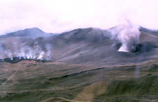
A news article stated that explosions from Mount Cameroon were observed by tourists who were in the area on 3 February. The tourists reported hearing strong explosions followed by observations of "flames" and ash.
Geological Summary. Mount Cameroon, one of Africa's largest volcanoes, rises above the coast of west Cameroon. The massive steep-sided volcano of dominantly basaltic-to-trachybasaltic composition forms a volcanic horst constructed above a basement of Precambrian metamorphic rocks covered with Cretaceous to Quaternary sediments. More than 100 small cinder cones, often fissure-controlled parallel to the long axis of the 1400 km3 edifice, occur on the flanks and surrounding lowlands. A large satellitic peak, Etinde (also known as Little Cameroon), is located on the S flank near the coast. Historical activity was first observed in the 5th century BCE by the Carthaginian navigator Hannon. During historical time, moderate explosive and effusive eruptions have occurred from both summit and flank vents. A 1922 SW-flank eruption produced a lava flow that reached the Atlantic coast, and a lava flow from a 1999 south-flank eruption stopped only 200 m from the sea. Explosive activity from two vents on the upper SE flank was reported in May 2000.
Source: Associated Press