Report on Kelud (Indonesia) — 12 February-18 February 2014
Smithsonian Institution / US Geological Survey
Weekly Volcanic Activity Report, 12 February-18 February 2014
Managing Editor: Sally Sennert.
Please cite this report as:
Global Volcanism Program, 2014. Report on Kelud (Indonesia) (Sennert, S, ed.). Weekly Volcanic Activity Report, 12 February-18 February 2014. Smithsonian Institution and US Geological Survey.
Kelud
Indonesia
7.935°S, 112.314°E; summit elev. 1730 m
All times are local (unless otherwise noted)
PVMBG reported that at 2115 on 13 February the Alert Level for Kelut was raised to 4 (on a scale of 1-4). Visitors and residents were prohibited from approaching the crater within a 10-km radius. BNPB reported that a major eruption occurred less than two hours later at 2250, followed by another large explosion at 2330. Ash plumes rose to an altitude of 17 km (55,800 ft) a.s.l. and caused ashfall in areas NE, NW, and W, as far as Pacitan (133 km WSW), Kulon Progo (236 km W), Temanggung (240 km WNW), and Banyuwangi (228 km E). Forty flights from the Juanda (81 km NE), Adi Sucipto Yogya (208 km W), and Adi Sumarmo Solo (175 km WNW) airports were cancelled. News articles reported that flights in and out of seven airports were cancelled or rerouted. Ashfall and tephra 5-8 cm in diameter caused structures to collapse, including schools, homes, and businesses.
On 14 February BNPB reported that the eruption had killed four people: one died due to a collapsing wall, one from ash inhalation, and two from “shortness of breath”. All four victims lived within 7 km of Kelut in the regency of Malang, an area that received ashfall up to 20 cm thick. By 0600 the number of displaced people reached 100,248, but the report also noted that activity had declined. A report issued later that day noted that 76,388 people remained evacuated. Seismicity continued to decline and was at moderate levels during 15-17 February. An 18 February report noted that a total of seven people in Malang had died, and that the ashfall had affected cattle health and dairy production, farms, and the water supply. Damage to infrastructure in Malang included 3,782 houses, 20 government buildings, 251 schools, nine hospitals, and 36 churches.
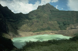
Geological Summary. The relatively inconspicuous Kelud stratovolcano contains a summit crater lake that has been the source of some of Indonesia's most deadly eruptions. A cluster of summit lava domes cut by numerous craters has given the summit a very irregular profile. Satellitic cones and lava domes are also located low on the E, W, and SSW flanks. Eruptive activity has in general migrated in a clockwise direction around the summit vent complex. More than 30 eruptions have been recorded since 1000 CE. The ejection of water from the crater lake during the typically short but violent eruptions has created pyroclastic flows and lahars that have caused widespread fatalities and destruction. After more than 5,000 people were killed during an eruption in 1919, an engineering project to drain the crater lake lowered the surface by more than 50 m. The 1951 eruption deepened the crater by 70 m, leaving 50 million cubic meters of water after the damaged drainage tunnels were repaired. Following more than 200 deaths in the 1966 eruption, a new deeper tunnel was constructed, and the lake's volume before the 1990 eruption was only about 1 million cubic meters.
Sources: Pusat Vulkanologi dan Mitigasi Bencana Geologi (PVMBG, also known as CVGHM), Badan Nacional Penanggulangan Bencana (BNPB), Jakarta Globe