Report on Wolf (Ecuador) — 20 May-26 May 2015
Smithsonian Institution / US Geological Survey
Weekly Volcanic Activity Report, 20 May-26 May 2015
Managing Editor: Sally Sennert.
Please cite this report as:
Global Volcanism Program, 2015. Report on Wolf (Ecuador) (Sennert, S, ed.). Weekly Volcanic Activity Report, 20 May-26 May 2015. Smithsonian Institution and US Geological Survey.
Wolf
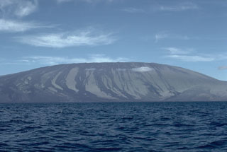
Ecuador
0.02°N, 91.35°W; summit elev. 1710 m
All times are local (unless otherwise noted)
According to IG the seismic station located on Fernandina Island recorded several events at Wolf (on Isabela Island) starting at 2350 on 24 May. The most significant signal occurred at 0058 on 25 May, corresponding to an explosion and the start of an eruption. At 0215 the Washington VAAC detected an ash plume that rose to an altitude of 10.7 km (35,000 ft) a.s.l. and drifted 65 km SW. At 0345 one ash plume drifted 250 km ENE at an altitude of 15.2 km (50,000 ft) a.s.l., and another drifted 250 km S at an altitude of 13.7 km (45,000 ft) a.s.l. Starting at 0428 the Hawai'i Institute of Geophysics and Planetology (HIGP) reported intense thermal anomalies on Wolf's SE flank based on MODIS satellite data. Galapagos National Park staff reported an arcuate fissure along the upper SSE rim and several lava flows descending the flanks. Later that day the VAAC noted a smaller ash emission that drifted 150 km SW, and a bright thermal anomaly that had persisted. Satellites detecting sulfur dioxide showed that the cloud was sulfur-dioxide rich and ash poor; ~100-200 kt of sulfur dioxide had been emitted during the first 13 hours of the eruption.
Geological Summary. Volcán Wolf, the highest volcano of the Galápagos Islands, straddles the equator at the north end of the archipelago's largest island, Isabela. The edifice has steeper slopes than most other Isabela volcanoes, reaching angles up to 35°. The summit caldera is 6 x 7 km across and 700 m deep. A prominent bench on the west side of the caldera rises 450 m above the caldera floor, much of which is covered by a lava flow erupted in 1982. Radial fissures concentrated along diffuse rift zones extend down the N, NW, and SE flanks, and submarine vents lie beyond the N and NW fissures. Similar unvegetated flows originating from a circumferential chain of spatter and scoria cones on the eastern caldera rim drape the forested flanks to the sea. The proportion of aa lava flows exceeds that of other Galápagos volcanoes. An eruption in in 1797 was the first observed and documented in the Galápagos Islands.
Sources: Instituto Geofísico-Escuela Politécnica Nacional (IG-EPN), Washington Volcanic Ash Advisory Center (VAAC), Galapagos Conservancy, Simon Carn, Hawai'i Institute of Geophysics and Planetology (HIGP) Thermal Alerts Team