Report on Marapi (Indonesia) — 20 January-26 January 2016
Smithsonian Institution / US Geological Survey
Weekly Volcanic Activity Report, 20 January-26 January 2016
Managing Editor: Sally Sennert.
Please cite this report as:
Global Volcanism Program, 2016. Report on Marapi (Indonesia) (Sennert, S, ed.). Weekly Volcanic Activity Report, 20 January-26 January 2016. Smithsonian Institution and US Geological Survey.
Marapi
Indonesia
0.38°S, 100.474°E; summit elev. 2885 m
All times are local (unless otherwise noted)
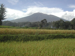
PVMBG reported that on most days during periods of clear weather from 1 November 2015 to 19 January 2016 white plumes rose above Marapi as high as 250 m above the crater. A phreatic explosion at 2233 on 14 November generated an ash plume, and ashfall was noted in Panyalaian and Aia Angek on the SW flank. Seismicity fluctuated during 1-18 January; earthquakes indicating emissions, tornillo-type events, and shallow volcanic signals slightly increased. The Alert Level remained at 2 (on a scale of 1-4). Residents and visitors were advised not to enter an area within 3 km of the summit.
Geological Summary. Gunung Marapi, not to be confused with the better-known Merapi volcano on Java, is Sumatra's most active volcano. This massive complex stratovolcano rises 2,000 m above the Bukittinggi Plain in the Padang Highlands. A broad summit contains multiple partially overlapping summit craters constructed within the small 1.4-km-wide Bancah caldera. The summit craters are located along an ENE-WSW line, with volcanism migrating to the west. More than 50 eruptions, typically consisting of small-to-moderate explosive activity, have been recorded since the end of the 18th century; no lava flows outside the summit craters have been reported in historical time.
Source: Pusat Vulkanologi dan Mitigasi Bencana Geologi (PVMBG, also known as CVGHM)