Report on La Palma (Spain) — 22 September-28 September 2021
Smithsonian Institution / US Geological Survey
Weekly Volcanic Activity Report, 22 September-28 September 2021
Managing Editor: Sally Sennert.
Please cite this report as:
Global Volcanism Program, 2021. Report on La Palma (Spain) (Sennert, S, ed.). Weekly Volcanic Activity Report, 22 September-28 September 2021. Smithsonian Institution and US Geological Survey.
La Palma
Spain
28.57°N, 17.83°W; summit elev. 2426 m
All times are local (unless otherwise noted)
The eruption at La Palma continued during 21-28 September, characterized by Strombolian explosions, lava fountaining from multiple vents, advancing lava flows, and sometimes dense, daily ash emissions. A strong increase in tremor amplitude during the afternoon of 21 September was coincident with intensifying Strombolian activity. Explosive activity again increased on 22 September and dense plumes with abundant amounts of ash rose 3-4.6 km (10,000-15,000 ft) a.s.l. and caused ashfall in areas downwind; ash deposits were 3 cm thick in an unspecified area 1 km from the vents. The main lava flow advanced W towards the coast. Ash emissions significantly increased on 23 September with plumes rising as high as 5 km (16,400 ft) a.s.l. A series of powerful explosions began at 1720 and shock waves could be seen propagating through the emission plumes. Vigorous lava fountaining was continuous. Volcanic tremor amplitude was high and variable, peaking at 1500 on 24 September with the highest values since the eruption started. The peak occurred just before two new vents opened on the flank of the main cone, and then notably decreased afterwards, but remained at high levels. Lava from the new vents rapidly traveled more than 1 km downslope, covering older flows, before slowing to 60-80 meters per hour. According to a news report, the explosions ejected tephra outside of the exclusion zone. An evacuation order was issued in the early afternoon for Tajuya, Tacande de Abajo, and part of Tacande de Arriba, affecting 300-400 people. Three airlines suspended flights to La Palma. The lava flow field had expanded to 1.9 square kilometers, destroyed more than 420 buildings, and covered 15.2 km of roads.
Tremor amplitude decreased around noon on 25 September, along with the intensity of the Strombolian explosions. During 25-26 September ash fell in nearby municipalities and as far as the E coast of the island. On 26 September the PEVOLCA steering committee recommended that residents who had evacuated two days earlier could return. The report described two main lava flows, with a highly fluid northern flow and a southern flow that was 2.5 km long. Sulfur dioxide emissions remained significant with an average rate of 25,000 tons per day, and ash plumes rose as high as 3 km above the vents. Lava continued to advance and flowed through Todoque, crossing the LP-213 road, just W of the main part of the town, at around 1900. The flow was 600 m across at the widest part and the leading edge was 4-6 m tall. Lava fountaining and low-intensity Strombolian explosions persisted. Copernicus EMS estimated that the lava covered 2.37 square kilometers, had destroyed 513 houses, and covered 18.9 km of roads. Multiple lava fountains feeding flows were visible on 27 September though the activity waned for a period of about eight hours. By the evening activity had resumed and low-intensity Strombolian explosions were visible.
Beginning at 0245 on 28 September lava fountains fed a new high-temperature, fast-moving flow that descended on top of older flank flows. The leading edge of the main flow continued to advance W and covered banana greenhouses, burning the plastic and igniting a storage of fertilizer resulting in small explosions and a brown odorous plume. About 140 more structures were covered by flows. In preparation for a possible ocean entry, authorities recommended that residents within a 5 km radius of the coastline keep their doors and windows closed, to stay away from windows in case they break, and to cover faces and skin in case of ashfall. Dense ash-and-gas plumes continued to rise from the main vents, as high as 5 km; the rising plume created gravity waves that looked like ripples moving away from the top of the plume. Late in the day lava reached the coastal area, descended a 100-m-high sea cliff, and by 2302 reached the ocean at Playa de los Guirres. Black-and-white plumes rose from where the lava contacted the water.
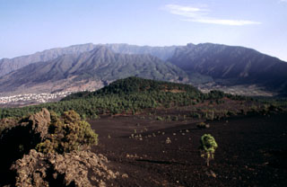
Geological Summary. The 47-km-long wedge-shaped island of La Palma, the NW-most of the Canary Islands, is composed of two large volcanic centers. The older northern one is cut by the steep-walled Caldera Taburiente, one of several massive collapse scarps produced by edifice failure to the SW. On the south, the younger Cumbre Vieja volcano is one of the most active in the Canaries. The elongated volcano dates back to about 125,000 years ago and is oriented N-S. Eruptions during the past 7,000 years have formed abundant cinder cones and craters along the axis, producing fissure-fed lava flows that descend steeply to the sea. Eruptions recorded since the 15th century have produced mild explosive activity and lava flows that damaged populated areas. The southern tip of the island is mantled by a broad lava field emplaced during the 1677-1678 eruption. Lava flows also reached the sea in 1585, 1646, 1712, 1949, 1971, and 2021.
Sources: Instituto Geográfico Nacional (IGN), Instituto Volcanológico de Canarias (INVOLCAN), Gobierno de Canaries, EL PAÍS, CNN, EL PAÍS, Toulouse Volcanic Ash Advisory Centre (VAAC), Copernicus Emergency Management Service