Report on Eyjafjallajokull (Iceland) — 2 June-8 June 2010
Smithsonian Institution / US Geological Survey
Weekly Volcanic Activity Report, 2 June-8 June 2010
Managing Editor: Sally Sennert.
Please cite this report as:
Global Volcanism Program, 2010. Report on Eyjafjallajokull (Iceland) (Sennert, S, ed.). Weekly Volcanic Activity Report, 2 June-8 June 2010. Smithsonian Institution and US Geological Survey.
Eyjafjallajokull
Iceland
63.633°N, 19.633°W; summit elev. 1651 m
All times are local (unless otherwise noted)
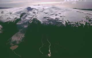
The Nordic Volcanological Center (NVC) at the Institute of Earth Sciences reported that on 2 June a white steam cloud from Eyjafjallajökull's summit caldera rose to an altitude of 2.5 km (8,200 ft) a.s.l. On 3 June, scientists visited the summit and noted that the main crater remained active, though it was less active than during the previous visit on 27 May; steam rose 200-400 m above the crater rim. The next day cloud cover prevented observations. During 3-4 June remobilized ash drifted over a wide area of S and SW Iceland.
Scientists noted increased tremor on 4 June and a black plume that rose to an altitude of 4.5 km (14,800 ft) a.s.l. Considerable rumbling noises were reported from an area 10 km S. Tremor levels fluctuated during the next three days. Plumes that rose from the summit caldera were mostly white with occasional dark areas at the base following explosive activity. Plumes drifted SW during 4-5 June and S during 6-7 June at altitudes of 3-6 km (9,800-19,700 ft) a.s.l. A new crater was seen in the W part of the caldera at the site of the new explosive activity.
Geological Summary. Eyjafjallajökull (also known as Eyjafjöll) is located west of Katla volcano. It consists of an elongated ice-covered stratovolcano with a 2.5-km-wide summit caldera. Fissure-fed lava flows occur on both the E and W flanks, but are more prominent on the western side. Although the volcano has erupted during historical time, it has been less active than other volcanoes of Iceland's eastern volcanic zone, and relatively few Holocene lava flows are known. An intrusion beneath the S flank from July-December 1999 was accompanied by increased seismic activity. The last historical activity prior to an eruption in 2010 produced intermediate-to-silicic tephra from the central caldera during December 1821 to January 1823.
Sources: Iceland Review, Institute of Earth Sciences