The Global Volcanism Program has no activity reports for Towada.
The Global Volcanism Program has no Weekly Reports available for Towada.
The Global Volcanism Program has no Bulletin Reports available for Towada.
This compilation of synonyms and subsidiary features may not be comprehensive. Features are organized into four major categories: Cones, Craters, Domes, and Thermal Features. Synonyms of features appear indented below the primary name. In some cases additional feature type, elevation, or location details are provided.
Cones |
||||
| Feature Name | Feature Type | Elevation | Latitude | Longitude |
| Aobuna | Stratovolcano | 733 m | ||
| Goshikiiwa | Stratovolcano | 613 m | ||
| Hakka | Stratovolcano | |||
| Herai-dake | Stratovolcano | |||
| Ninokura | Stratovolcano | |||
|
Ohanabeyama
Ohanabe-yama |
Stratovolcano | 1011 m | ||
| Oirase | Cone | |||
| Towada-yama | Stratovolcano | 1054 m | ||
| Towari-yama | Stratovolcano | 991 m | ||
| Zakura Misaka | Stratovolcano | |||
Craters |
||||
| Feature Name | Feature Type | Elevation | Latitude | Longitude |
| Nakanoumi | Caldera | |||
| Towada | Pleistocene caldera | |||
Domes |
||||
| Feature Name | Feature Type | Elevation | Latitude | Longitude |
|
Gomonseki
Gomon-ishi |
Dome | 402 m | ||
|
Ogurayama
Ogura-yama |
Dome | 678 m | 40° 27' 36" N | 140° 54' 36" E |
|
|
||||||||||||||||||||||||
There is data available for 8 confirmed Holocene eruptive periods.
0915 Aug 17 Confirmed Eruption Max VEI: 5
| Episode 1 | Eruption Episode | Goshikiiwa (NE rim Nakanoumi crater) | |||||||||||||||||||||||||||||||||||||||||||||||||||||||||||
|---|---|---|---|---|---|---|---|---|---|---|---|---|---|---|---|---|---|---|---|---|---|---|---|---|---|---|---|---|---|---|---|---|---|---|---|---|---|---|---|---|---|---|---|---|---|---|---|---|---|---|---|---|---|---|---|---|---|---|---|---|
| 0915 Aug 17 - Unknown | Evidence from Observations: Reported | |||||||||||||||||||||||||||||||||||||||||||||||||||||||||||
|
List of 10 Events for Episode 1 at Goshikiiwa (NE rim Nakanoumi crater)
| ||||||||||||||||||||||||||||||||||||||||||||||||||||||||||||
0750 BCE (?) Confirmed Eruption Max VEI: 4
| Episode 1 | Eruption Episode | Nakanoumi, To-B tephra | ||||||||||||||||||||||||||||||||||
|---|---|---|---|---|---|---|---|---|---|---|---|---|---|---|---|---|---|---|---|---|---|---|---|---|---|---|---|---|---|---|---|---|---|---|---|
| 0750 BCE (?) - Unknown | Evidence from Isotopic: 14C (calibrated) | ||||||||||||||||||||||||||||||||||
|
List of 5 Events for Episode 1 at Nakanoumi, To-B tephra
| |||||||||||||||||||||||||||||||||||
4150 BCE (?) Confirmed Eruption Max VEI: 5
| Episode 1 | Eruption Episode | Goshikiiwa (Nakanoumi), To-C tephra | ||||||||||||||||||||||||||||||||||
|---|---|---|---|---|---|---|---|---|---|---|---|---|---|---|---|---|---|---|---|---|---|---|---|---|---|---|---|---|---|---|---|---|---|---|---|
| 4150 BCE (?) - Unknown | Evidence from Isotopic: 14C (calibrated) | ||||||||||||||||||||||||||||||||||
|
List of 5 Events for Episode 1 at Goshikiiwa (Nakanoumi), To-C tephra
| |||||||||||||||||||||||||||||||||||
5550 BCE (?) Confirmed Eruption Max VEI: 3 (?)
| Episode 1 | Eruption Episode | Goshikiiwa, To-D' tephra | |||||||||||||||||||
|---|---|---|---|---|---|---|---|---|---|---|---|---|---|---|---|---|---|---|---|---|
| 5550 BCE (?) - Unknown | Evidence from Isotopic: 14C (calibrated) | |||||||||||||||||||
|
List of 2 Events for Episode 1 at Goshikiiwa, To-D' tephra
| ||||||||||||||||||||
6250 BCE (?) Confirmed Eruption Max VEI: 4
| Episode 1 | Eruption Episode | Goshikiiwa, To-D tephra; Oguni Pumice | |||||||||||||||||||||||||||||
|---|---|---|---|---|---|---|---|---|---|---|---|---|---|---|---|---|---|---|---|---|---|---|---|---|---|---|---|---|---|---|
| 6250 BCE (?) - Unknown | Evidence from Isotopic: 14C (calibrated) | |||||||||||||||||||||||||||||
|
List of 4 Events for Episode 1 at Goshikiiwa, To-D tephra; Oguni Pumice
| ||||||||||||||||||||||||||||||
7250 BCE (?) Confirmed Eruption Max VEI: 5 (?)
| Episode 1 | Eruption Episode | Goshikiiwa, To-E tephra; Nambu Pumice | ||||||||||||||||||||||||||||||||||
|---|---|---|---|---|---|---|---|---|---|---|---|---|---|---|---|---|---|---|---|---|---|---|---|---|---|---|---|---|---|---|---|---|---|---|---|
| 7250 BCE (?) - Unknown | Evidence from Isotopic: 14C (calibrated) | ||||||||||||||||||||||||||||||||||
|
List of 5 Events for Episode 1 at Goshikiiwa, To-E tephra; Nambu Pumice
| |||||||||||||||||||||||||||||||||||
8250 BCE (?) Confirmed Eruption Max VEI: 5
| Episode 1 | Eruption Episode | Goshikiiwa, To-F tephra | ||||||||||||||||||||||||
|---|---|---|---|---|---|---|---|---|---|---|---|---|---|---|---|---|---|---|---|---|---|---|---|---|---|
| 8250 BCE (?) - Unknown | Evidence from Isotopic: 14C (calibrated) | ||||||||||||||||||||||||
|
List of 3 Events for Episode 1 at Goshikiiwa, To-F tephra
| |||||||||||||||||||||||||
9490 BCE (?) Confirmed Eruption Max VEI: 3
| Episode 1 | Eruption Episode | Nakanoumi, To-G tephra; Shingo Pumice | |||||||||||||||||||||||||||||
|---|---|---|---|---|---|---|---|---|---|---|---|---|---|---|---|---|---|---|---|---|---|---|---|---|---|---|---|---|---|---|
| 9490 BCE (?) - Unknown | Evidence from Isotopic: 14C (calibrated) | |||||||||||||||||||||||||||||
|
List of 4 Events for Episode 1 at Nakanoumi, To-G tephra; Shingo Pumice
| ||||||||||||||||||||||||||||||
There is no Deformation History data available for Towada.
There is no Emissions History data available for Towada.
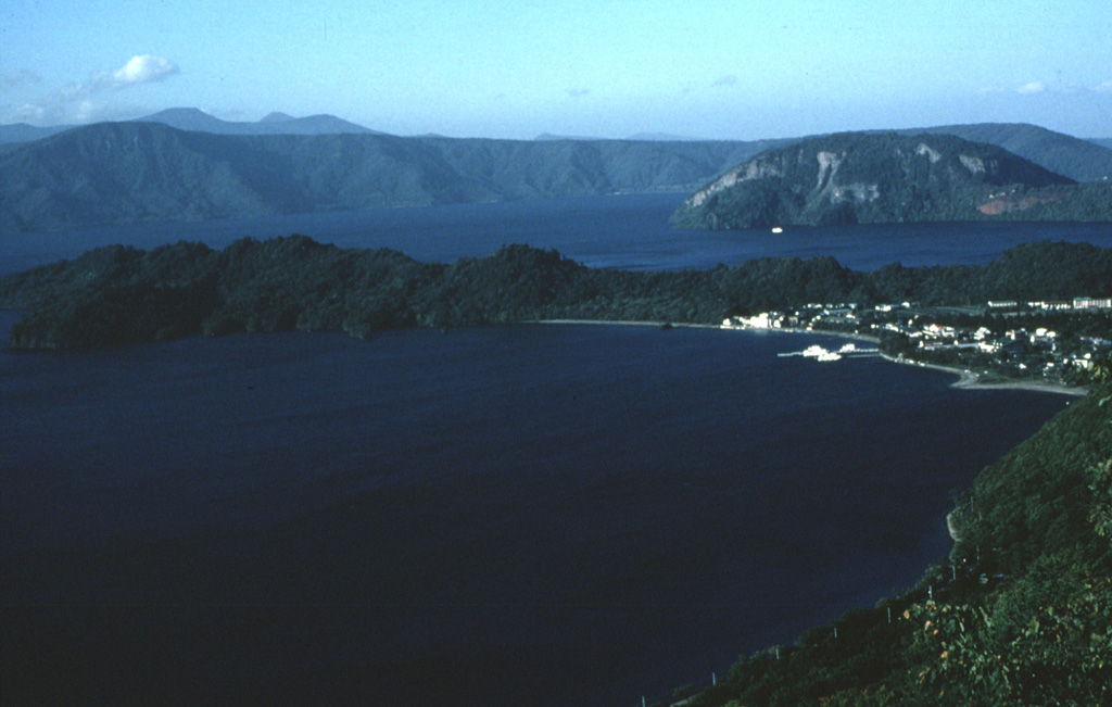
 The 11-km-wide lake-filled Towada caldera formed during as many as six major explosive eruptions over a 40,000-year period ending about 13,000 years ago. This view from the south shows the western and northern caldera rims, which reach up to 500 m above the lake. The base of the caldera is 380 m below the lake surface.
 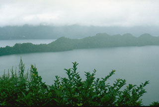 The peninsula across the center of the photo is the SW rim of Nakanoumi caldera. The 3-km-wide caldera formed about 5,400 years ago during the largest Towada Holocene eruption . The eruption was followed by the collapse of the Goshikiiwa cone at the southern end of the caldera. Clouds obscure the western caldera rim in the background.
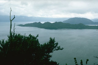 The rounded Ogurayama lava dome to the upper right formed at the end of the 915 CE Towada eruption. Three eruptions were accompanied by the emplacement of the 5 km3 Kemanai pyroclastic flow, which covered several large wooden buildings along the Yonesawa River. The dome formed along the NE rim of the Nakanoumi caldera, with its SW rim forming the peninsula in the center of the photo. The northern wall of Towada caldera appears in the distance.
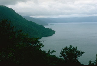
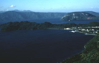 The 11-km-wide lake-filled Towada caldera, whose far northern wall is seen here in the distance, formed during a series of major explosive eruptions over a 40,000-year period ending about 13,000 years ago. The peninsula across the center is the rim of Nakanoumi caldera that formed by the collapse of the Goshikiiwa cone. The Ogurayama dome to the upper right was the source of the 915 CE eruption.
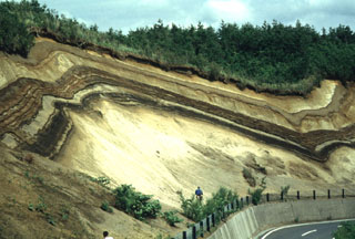 A roadcut west of the Ninokura dam exposes deposits from Towada. The thick light-colored unit at the base is the Hachinohe ignimbrite that formed about 13,000 years ago during the last of a series of explosive eruptions that resulted in the incremental formation of Towada's 11-km-wide caldera. The thinner light- and dark-colored deposits above the Hachinohe ignimbrite were produced by post-caldera eruptions, the most recent of which took place in 915 CE.
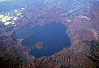 The 11-km-wide Towada caldera, seen here from the E, formed during as many as six major explosive eruptions over a 40,000-year period ending about 13,000 years ago. The two peninsulas extending into the large caldera lake are the rims of Nakanoumi caldera, formed by collapse of the Goshikiiwa cone in the SSE section of the caldera. The rounded lava dome that was constructed at the tip of lower peninsula is Ogurayama, the source of the 915 CE eruption.
The maps shown below have been scanned from the GVP map archives and include the volcano on this page. Clicking on the small images will load the full 300 dpi map. Very small-scale maps (such as world maps) are not included. The maps database originated over 30 years ago, but was only recently updated and connected to our main database. We welcome users to tell us if they see incorrect information or other problems with the maps; please use the Contact GVP link at the bottom of the page to send us email.
The following 2 samples associated with this volcano can be found in the Smithsonian's NMNH Department of Mineral Sciences collections, and may be availble for research (contact the Rock and Ore Collections Manager). Catalog number links will open a window with more information.
| Catalog Number | Sample Description | Lava Source | Collection Date |
|---|---|---|---|
| NMNH 116397-3 | Pumice | -- | -- |
| NMNH 116397-4 | Pumice | -- | -- |
| Copernicus Browser | The Copernicus Browser replaced the Sentinel Hub Playground browser in 2023, to provide access to Earth observation archives from the Copernicus Data Space Ecosystem, the main distribution platform for data from the EU Copernicus missions. |
| MIROVA | Middle InfraRed Observation of Volcanic Activity (MIROVA) is a near real time volcanic hot-spot detection system based on the analysis of MODIS (Moderate Resolution Imaging Spectroradiometer) data. In particular, MIROVA uses the Middle InfraRed Radiation (MIR), measured over target volcanoes, in order to detect, locate and measure the heat radiation sourced from volcanic activity. |
| MODVOLC Thermal Alerts | Using infrared satellite Moderate Resolution Imaging Spectroradiometer (MODIS) data, scientists at the Hawai'i Institute of Geophysics and Planetology, University of Hawai'i, developed an automated system called MODVOLC to map thermal hot-spots in near real time. For each MODIS image, the algorithm automatically scans each 1 km pixel within it to check for high-temperature hot-spots. When one is found the date, time, location, and intensity are recorded. MODIS looks at every square km of the Earth every 48 hours, once during the day and once during the night, and the presence of two MODIS sensors in space allows at least four hot-spot observations every two days. Each day updated global maps are compiled to display the locations of all hot spots detected in the previous 24 hours. There is a drop-down list with volcano names which allow users to 'zoom-in' and examine the distribution of hot-spots at a variety of spatial scales. |
|
WOVOdat
Single Volcano View Temporal Evolution of Unrest Side by Side Volcanoes |
WOVOdat is a database of volcanic unrest; instrumentally and visually recorded changes in seismicity, ground deformation, gas emission, and other parameters from their normal baselines. It is sponsored by the World Organization of Volcano Observatories (WOVO) and presently hosted at the Earth Observatory of Singapore.
GVMID Data on Volcano Monitoring Infrastructure The Global Volcano Monitoring Infrastructure Database GVMID, is aimed at documenting and improving capabilities of volcano monitoring from the ground and space. GVMID should provide a snapshot and baseline view of the techniques and instrumentation that are in place at various volcanoes, which can be use by volcano observatories as reference to setup new monitoring system or improving networks at a specific volcano. These data will allow identification of what monitoring gaps exist, which can be then targeted by remote sensing infrastructure and future instrument deployments. |
| Volcanic Hazard Maps | The IAVCEI Commission on Volcanic Hazards and Risk has a Volcanic Hazard Maps database designed to serve as a resource for hazard mappers (or other interested parties) to explore how common issues in hazard map development have been addressed at different volcanoes, in different countries, for different hazards, and for different intended audiences. In addition to the comprehensive, searchable Volcanic Hazard Maps Database, this website contains information about diversity of volcanic hazard maps, illustrated using examples from the database. This site is for educational purposes related to volcanic hazard maps. Hazard maps found on this website should not be used for emergency purposes. For the most recent, official hazard map for a particular volcano, please seek out the proper institutional authorities on the matter. |
| IRIS seismic stations/networks | Incorporated Research Institutions for Seismology (IRIS) Data Services map showing the location of seismic stations from all available networks (permanent or temporary) within a radius of 0.18° (about 20 km at mid-latitudes) from the given location of Towada. Users can customize a variety of filters and options in the left panel. Note that if there are no stations are known the map will default to show the entire world with a "No data matched request" error notice. |
| UNAVCO GPS/GNSS stations | Geodetic Data Services map from UNAVCO showing the location of GPS/GNSS stations from all available networks (permanent or temporary) within a radius of 20 km from the given location of Towada. Users can customize the data search based on station or network names, location, and time window. Requires Adobe Flash Player. |
| DECADE Data | The DECADE portal, still in the developmental stage, serves as an example of the proposed interoperability between The Smithsonian Institution's Global Volcanism Program, the Mapping Gas Emissions (MaGa) Database, and the EarthChem Geochemical Portal. The Deep Earth Carbon Degassing (DECADE) initiative seeks to use new and established technologies to determine accurate global fluxes of volcanic CO2 to the atmosphere, but installing CO2 monitoring networks on 20 of the world's 150 most actively degassing volcanoes. The group uses related laboratory-based studies (direct gas sampling and analysis, melt inclusions) to provide new data for direct degassing of deep earth carbon to the atmosphere. |
| Large Eruptions of Towada | Information about large Quaternary eruptions (VEI >= 4) is cataloged in the Large Magnitude Explosive Volcanic Eruptions (LaMEVE) database of the Volcano Global Risk Identification and Analysis Project (VOGRIPA). |
| EarthChem | EarthChem develops and maintains databases, software, and services that support the preservation, discovery, access and analysis of geochemical data, and facilitate their integration with the broad array of other available earth science parameters. EarthChem is operated by a joint team of disciplinary scientists, data scientists, data managers and information technology developers who are part of the NSF-funded data facility Integrated Earth Data Applications (IEDA). IEDA is a collaborative effort of EarthChem and the Marine Geoscience Data System (MGDS). |

