Global Volcanism Program | Image GVP-11135

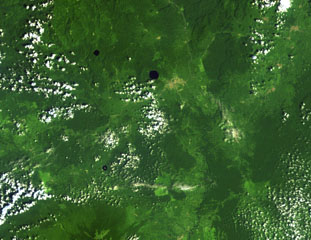
Three lake-filled maars dot the Tombel Graben between Mount Cameroon (lower left) and lava flows from Manengouba volcano (top). The Mungo River runs from N to S across the right side of this Landsat image. The largest maar, Barombi Mbo, lies just west of the brown-colored area of the town of Kumba, and Barombi Koto is at the lower left. A large number of scoria cones, including the young cone of Le Djungo (Mont Pelé) dot the 10-20 km wide graben.
NASA Landsat image, 1999 (courtesy of Hawaii Synergy Project, Univ. of Hawaii Institute of Geophysics & Planetology).
![]() This image is made available as a Public Domain Work, but proper attribution is appreciated.
This image is made available as a Public Domain Work, but proper attribution is appreciated.
Galleries: Maars
Keywords: remote sensing | maar | crater lake
Tombel Graben