Report on Tinakula (Solomon Islands) — February 2022
Bulletin of the Global Volcanism Network, vol. 47, no. 2 (February 2022)
Managing Editor: Benjamin Andrews.
Edited by Kadie L. Bennis.
Tinakula (Solomon Islands) Thermal anomalies, gas-and-steam emissions, and possible lava flows during July-December 2021
Please cite this report as:
Global Volcanism Program, 2022. Report on Tinakula (Solomon Islands) (Bennis, K.L., and Andrews, B., eds.). Bulletin of the Global Volcanism Network, 47:2. Smithsonian Institution. https://doi.org/10.5479/si.GVP.BGVN202202-256010
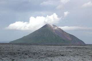
Tinakula
Solomon Islands
10.386°S, 165.804°E; summit elev. 796 m
All times are local (unless otherwise noted)
Tinakula is located 100 km NE of the Solomon Trench at the N end of the Santa Cruz Islands. It is a small 3.5-km-wide island with a breached summit crater that extends to below sea level; landslides enlarged this scarp in 1965, creating an embayment on the NW coast. Its most recent eruption period began in December 2018 and has consisted of weak thermal anomalies and intermittent gas-and-steam plumes. Similar activity continued during this reporting period from July through December 2021 based on satellite data, as ground observations are rarely available.
Infrared MODIS satellite data processed by MIROVA (Middle InfraRed Observation of Volcanic Activity) detected a total of 18 weak thermal anomalies during July through December: once during late July, three times during early August, seven times during October, four times during November, and three times during late December (figure 48).
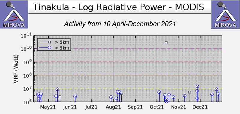 |
Figure 48. Weak thermal anomalies at Tinakula were detected once during late July, three times during early August, seven times during October, four times during November, and three times during late December 2021, based on this MIROVA (Log Radiative Power) graph. Courtesy of MIROVA. |
Though cloudy weather often obscured clear views of the summit crater, Sentinel-2 infrared satellite imagery showed a possible lava flow descending the NW flank accompanied by gas-and-steam emissions that drifted NW on 28 October (figure 49). By 27 November the flow on the NW flank had cooled, but there were two small anomalies on the W flank that may represent a different lava flow. On 22 December two small possible lava flows moved a short distance from the summit crater to the NW and W; gas-and-steam emissions drifted generally W.
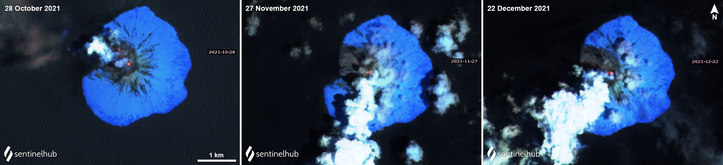 |
Figure 49. Sentinel-2 infrared satellite imagery showed a thermal anomaly (bright yellow-orange) on clear weather days on 28 October (left), 27 November (middle), and 22 December (right) 2021 accompanied by gas-and-steam emissions that drifted NW, SW, and SW, respectively. A possible lava flow was visible on the NW flank on 28 October. By 27 November the NW lava flow had stopped, but two anomalies were visible on the W flank, possibly representing a different flow. On 22 December two short possible lava flows were detected on the NW and W flanks. Images processed using “Atmospheric penetration” (bands 12, 11, 8a) rendering. Courtesy of Sentinel Hub Playground. |
Geological Summary. The small 3.5-km-wide island of Tinakula is the exposed summit of a massive stratovolcano at the NW end of the Santa Cruz islands. It has a breached summit crater that extends from the summit to below sea level. Landslides enlarged this scarp in 1965, creating an embayment on the NW coast. The Mendana cone is located on the SE side. The dominantly andesitic volcano has frequently been observed in eruption since the era of Spanish exploration began in 1595. In about 1840, an explosive eruption apparently produced pyroclastic flows that swept all sides of the island, killing its inhabitants. Recorded eruptions have frequently originated from a cone constructed within the large breached crater. These have left the upper flanks and the steep apron of lava flows and volcaniclastic debris within the breach unvegetated.
Information Contacts: MIROVA (Middle InfraRed Observation of Volcanic Activity), a collaborative project between the Universities of Turin and Florence (Italy) supported by the Centre for Volcanic Risk of the Italian Civil Protection Department (URL: http://www.mirovaweb.it/); Sentinel Hub Playground (URL: https://www.sentinel-hub.com/explore/sentinel-playground).