Report on Manam (Papua New Guinea) — December 1992
Bulletin of the Global Volcanism Network, vol. 17, no. 12 (December 1992)
Managing Editor: Lindsay McClelland.
Manam (Papua New Guinea) Activity declines after 4 months of vigorous eruption
Please cite this report as:
Global Volcanism Program, 1992. Report on Manam (Papua New Guinea) (McClelland, L., ed.). Bulletin of the Global Volcanism Network, 17:12. Smithsonian Institution. https://doi.org/10.5479/si.GVP.BGVN199212-251020
Manam
Papua New Guinea
4.08°S, 145.037°E; summit elev. 1807 m
All times are local (unless otherwise noted)
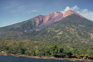
"Activity . . . during December declined to a low level, after four months of eruptive activity. Emissions from Main Crater on 1-8, 20, and 28 December consisted of moderate-to-thick vapour with light ash content rising 500-1000 m above the summit. Light ashfalls were reported in coastal areas on the NE and SE sides of the island. Occasional weak-to-loud roaring noises were heard, only during the first half of the month. Activity at Southern Crater was similar to that in November, with emissions of white and blue vapours in small-to-moderate volumes. Weak-to-bright night glow from both summit craters was visible until 18 December. From the 19th until the end of the month, both summit craters were covered by atmospheric clouds.
"The decrease in seismic activity that began in mid-November stabilized at a low level at the beginning of December, and continued throughout the month. Radial tilt measurements showed a 3-µrad deflation during the last two weeks of the month after being stable since 11 November."
Geological Summary. The 10-km-wide island of Manam, lying 13 km off the northern coast of mainland Papua New Guinea, is one of the country's most active volcanoes. Four large radial valleys extend from the unvegetated summit of the conical basaltic-andesitic stratovolcano to its lower flanks. These valleys channel lava flows and pyroclastic avalanches that have sometimes reached the coast. Five small satellitic centers are located near the island's shoreline on the northern, southern, and western sides. Two summit craters are present; both are active, although most observed eruptions have originated from the southern crater, concentrating eruptive products during much of the past century into the SE valley. Frequent eruptions, typically of mild-to-moderate scale, have been recorded since 1616. Occasional larger eruptions have produced pyroclastic flows and lava flows that reached flat-lying coastal areas and entered the sea, sometimes impacting populated areas.
Information Contacts: H. Patia and B. Talai, RVO.