Report on Witori (Papua New Guinea) — December 2003
Bulletin of the Global Volcanism Network, vol. 28, no. 12 (December 2003)
Managing Editor: Richard Wunderman.
Witori (Papua New Guinea) All vents still degassing; low seismicity (5-7 VT earthquakes per day)
Please cite this report as:
Global Volcanism Program, 2003. Report on Witori (Papua New Guinea) (Wunderman, R., ed.). Bulletin of the Global Volcanism Network, 28:12. Smithsonian Institution. https://doi.org/10.5479/si.GVP.BGVN200312-252080
Witori
Papua New Guinea
5.5745°S, 150.5161°E; summit elev. 724 m
All times are local (unless otherwise noted)
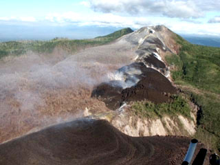
Pago remained quiet, with all vents continuing to release weak, thin white vapor during 10 October-14 December 2003. Seismicity was generally low, with daily averages of 5-7 small volcano-tectonic earthquakes. The highest number of daily events through 26 November were the 45 recorded on 28 October.
Geological Summary. The active Pago cone has grown within the Witori caldera (5.5 x 7.5 km) on the northern coast of central New Britain contains the active Pago cone. The gently sloping outer caldera flanks consist primarily of dacitic pyroclastic-flow and airfall deposits produced during a series of five major explosive eruptions from about 5,600 to 1,200 years ago, many of which may have been associated with caldera formation. Pago cone may have formed less than 350 years ago; it has grown to a height above the caldera rim, and a series of ten dacitic lava flows from it covers much of the caldera floor. The youngest of these was erupted during 2002-2003 from vents extending from the summit nearly to the NW caldera wall. The Buru caldera cuts the SW flank.
Information Contacts: Ima Itikarai, Rabaul Volcano Observatory (RVO), P.O. Box 386, Rabaul, Papua New Guinea.